Image Processing Reference
In-Depth Information
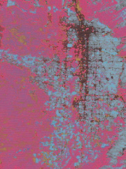
Fig. 6.13
Color image of classification applied to Salt Lake Valley: green vegetation applied to green
color gun, dry vegetation to blue color gun, and bare soil to red color gun. Black areas are unassigned
imperious surface, but may include small amounts of other cover types, including water (Card
1993
)
Figure
6.13
displays the four fractions on three color guns as: green vegetation to
green, dry vegetation to blue, and bare soil to red. Pure, bright colors of green, blue,
and red represent 100% of the cover type. Mixes of green and dry vegetation appear
as hues from green to cyan to blue; mixes of green vegetation and soil appear as
hues from green to yellow to red; mixes of dry vegetation to soil appear as hues from
blue to magenta to red. By “default” impervious surface is basically black where the
other three fractions are minimal. The black or near black also represents shade,
prominent in the commercial and high density residential high-rise district, as well
as a few small water bodies. The advantage of the display is that all four fractions
are discernable in one color image, and mixes are integrated into the same image.
6.4.4
Thematic Mapper Data: Radial Transects
for Environmental Patterns
Phinn et al. (
2002
) applied the V-I-S model to TM imagery of Brisbane to determine
urban environmental patterns of the city. The investigators claim that the model