Environmental Engineering Reference
In-Depth Information
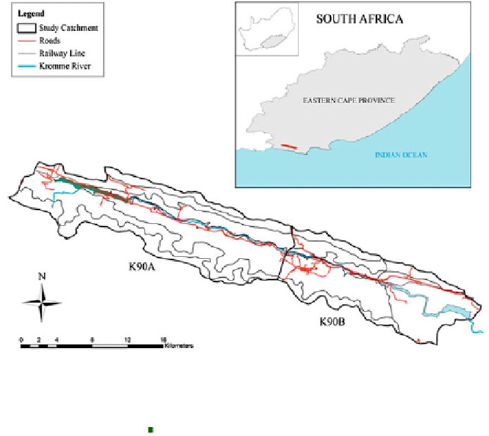
Fig. 16.5 The location of the Kromme River study catchments (K90A and K90B) and the
position of the Churchill Dam in the South Eastern corner of the catchment. The Kromme River is
located in the Eastern Cape Province of South Africa and the Nelson Mandela Bay metropolitan
area receives 24 % of its water from the Churchill Dam. Solid black lines within the catchment
delineate 11 subcatchments,
the remaining palmiet wetlands,
Churchill Dam
Suuranys Mountains (±1,050 m) to the north, and the Tsitsikamma Mountains
(±1500 m) to the south, both running from east to west.
Rainfall in the region is unpredictable, but tends to exhibit a bimodal pattern,
with maximums in spring and autumn (Midgley et al.
1994
). Mean annual pre-
cipitation (MAP) for the entire catchment is ±614 mm. Mean annual runoff (MAR)
for the entire catchment is ±75 mm which is ±11 % of the rainfall (WR2005).
The catchment has been heavily transformed by agriculture and alien invasion
(Fig.
16.6
a). Groundwater recharge rates are estimated to be fairly high despite the
relatively low rainfall, largely because of the shallow soils in the mountain slopes
and the low water-use of fynbos (Fig.
16.6
b). Kareedouw (population under 1,000)
is the only town in the catchment (Fig.
16.6
c). The catchment consists predomi-
nantly of shales and sandstones of the Cape Supergroup (Toerien and Hill
1989
)
(Fig.
16.6
d). The Cape Fold Belt is part of an intensely folded range with dipping
beds forming a trellis drainage pattern (Lewis
2008
). There are six large and five
minor tributaries entering from the southern mountain range, and seven large and
numerous minor tributaries entering from the drier northern mountain range in the
upper catchment (Haigh et al.
2002
). River flow from the northern tributaries is
mostly seasonal. Several of the tributaries have alluvial fans which limit the extent
Search WWH ::

Custom Search