Environmental Engineering Reference
In-Depth Information
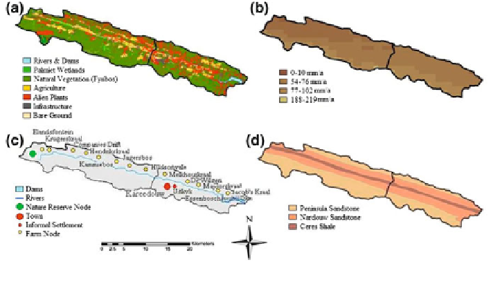
Fig. 16.6 Characteristics of the upper Kromme Catchments: a vegetation and land-use, b ground
water recharge (mm/annum), c towns and farms and d geology (Middleton and Bailey
2008
)
of the palmiet (Prionium serratum) wetlands. Historically, the palmiet stabilized
the floodplain alluvium, forming peat basins which would have covered a large
area of the floodplain (Haigh et al.
2002
).
16.2.2 Land-Use Changes
Land-use in the Kromme was mapped at high resolution (~5 m) spanning four
decades: 1954, 1969, 1986, 2007. These time-slices were supplemented with a
reference state based on a reconstruction of the land-cover of the Kromme system
prior to European occupation, and using the Garden Route Initiatives Vegetation
Map (Vlok et al.
2008
). Land-use mapping was done using 1:20,000 aerial pho-
tographs in a GIS system (ArcMap) to divide the area into 15 pre-selected land-
cover categories (Table
16.1
). The Fynbos was divided into 10 types by Vlok et al.
(
2008
) but these were amalgamated into two categories for the modelling study
based on whether the vegetation type classified as productive or unproductive for
livestock. Areas of fynbos that was mapped as heavily degraded by over-grazing or
altered fire regimes were kept as a separated class.
Maps are currently in the WGS 84 geographic co-ordinate system, and pro-
jected using Transverse Mercator Projection. Areas that were invaded by alien
plants were only distinguished if they had reached maturity and the density was
greater than that of 80 %. Canopy cover values lower than this are difficult to
distinguish from indigenous vegetation in aerial photographs. There is a small
degree of error, which varies depending on the difficulty of identifying and
mapping each land-use category. The most difficult land-cover type to map was the
Search WWH ::

Custom Search