Travel Reference
In-Depth Information
The top of Mt. Everts shows an angular unconformity, formed where the uppermost horizontal
volcanic deposits lie on top of tilted sedimentary layers.
A Sign of Violent Earth Movement
The photo (taken from a mile farther north) shows another sign of renewed geological
activity on Mount Everts. In the left half you see where 100-million-year-old sediments are
tilted down toward the north. These formerly flat-lying sediments were tilted, eroded to
form a horizontal ground surface of exposed edges, and then covered with tephra. Geolo-
gists call this kind of intersection an angular unconformity. This shows the quiet period
was ended by a regional tilting, followed by eruption of the Huckleberry Ridge Caldera.
4.0/14.1 Undine Falls
on Lava Creek. This triple waterfall has a total drop of over 100 feet
(30 m). Geologist Arnold Hague named it in 1885. In classical mythology, undines were water
spirits who could earn themselves a soul by marrying a mortal and bearing his child.
Like many falls in the park, Undine has an interesting geologic origin. About 700,000 years
ago, the predecessor of Lava Creek was flowing through the valley to the east of the falls and
gently eroding old shales that are about 100 million years old. A basalt lava flow then erupted
and flowed down the valley, filling the low areas. Lava Creek is now flowing over the much
harder basalt and has started to cut down through it.
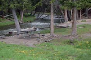
4.4/13.7
Lava Creek picnic area, in a particularly delightful setting that used to hold
a campground.
Lava Creek picnic area
Lava Creek Trail
can be accessed from the north side of the road by crossing the bridge
over Lava Creek just east of the picnic area. The 4-mile-long (6.4 km) trail leads mostly down-
hill to end at Mammoth Hot Springs.