Travel Reference
In-Depth Information
8.6/4.8
Parking for
Gibbon Falls.
At 84 feet (26 m), Gibbon Falls is not one of the highest
in Yellowstone, but it is remarkably wide. It's also a geologically significant spot where the river
flows very near the northern edge of the Yellowstone Caldera
[GEO.11].
A walkway from this parking lot parallels the river for 0.2 mile (0.3 km), provides interest-
ing interpretive signs, and affords excellent views from the brink to the entire breadth of the
falls at the walkway's southern end.
9.1/4.3
Side road to the large Gibbon Falls picnic area, which was left quite bleak
by the 1988 North Fork fire.
9.8/3.6
In this area the road cut exposes a thick bed of tephra—Lava Creek tuff—deposited
close to the Yellowstone Caldera edge.
11.1/2.3
This section of the Gibbon River shows the tendency of a river channel to meander
through a nearly level valley.
11.9/1.5 Tuff Cliff
picnic area. A large section of the cliff fell as a result of the
1959 Hebgen Lake earthquake. Notice how a thick stand of lodgepole pines has grown back
since the 1988 North Fork fire, making the cliff now hard to see.
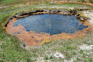
12.6/0.8
Short road to parking for
Terrace Spring thermal area.
A stroll of perhaps 0.3 mile (0.5 km) around this wheelchair-accessible boardwalk takes
you past two pools, the higher and cooler one called
Bath Spring.
The night of the 1959 earth-
quake near Hebgen Lake, a couple was bathing here in the nude—until the spring drained
completely! Very close to the road is
Terrace Spring
itself, a large hot lake.
Algae now grow in Bath Spring (2008).