Geoscience Reference
In-Depth Information
NNW
SSE
0
20
40
60
80
100
-100
1
-50
0
50
d
100
5000
1
5500
6000
6500
7000
c
7500
-100
2
-50
0
50
b
100
5000
2
5500
6000
6500
7000
a
7500
0
20
40
60
80
100
Axis
Distance (km)
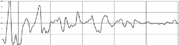
Fig. 8
Selected examples of bathymetric profiles nearly perpendicular to the western Kuril Trench.
Positions of the profiles are shown in Fig.
7
. (
a
) and (
c
) show the original bathymetric (
solid
) and
filtered (
broken
) profiles. (
b
) and (
d
) show the residual profiles calculated by subtracting filtered
values from the original water depths
southern part (Fig.
10
). Most of bending-related topographic structures in the
northern segment of the Japan Trench are subparallel to the trench axis. The
bending-related topographic structures are confined to areas less than ~80 km away
from the trench axis (Fig.
11
). Topographic expressions of these north of 39°40¢N
are a half graben, an asymmetric graben and ridges, which is similar to that of the
western Kuril Trench. The height of bending-related topographic structures does
not show any gradual trenchward increase. Some of bending-related topographic
structures north of 40°N have the same strike as those of Kuril Trench.
In the middle region of the northern segment between 38°50¢N and 39°40¢N,
bending-related escarpments form symmetric grabens subparallel to the trench axis


Search WWH ::

Custom Search