Environmental Engineering Reference
In-Depth Information
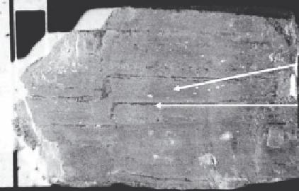
Clay layer
Fine silt layer
2 cm
In
FIGURE 2.32
Fine-grained lacustrine deposit. (Photo by Daniel T. Rogers.)
portion of the United States, evaporation of lake water leaves behind evaporite deposits.
Fine-grained lacustrine deposits tend to be thinly layered or stratified. Figure 2.32 is an
example of a thinly layered lacustrine deposit.
2.5.4 Eolian
Eolian (sometimes referred to as Aeolian) deposits result from the wind, and in the United
States occur primarily in arid or semiarid climates such as the southwest because these
areas often have a large supply of unconsolidated sediments. Many other regions, how-
ever, also exhibit eolian deposition generated during the last 2 million years. Some of the
locations include parts of Nebraska, Kansas, Texas, South Dakota, Colorado, Oklahoma,
Illinois, Iowa, sections of the east coast, southwest, and many other areas (Gustavson et al.
1991; Gibbard and Kolfschoten 2004).
Loess
is a typical wind-blown deposit consisting
primarily of silt-sized fragments. Most loess deposits were derived originally from glacial
till, and then transported by the wind.
2.5.5 Wetlands
A
wetland
is an area whose soil is saturated with water permanently or seasonally but
is saturated long enough to support aquatic plants. Wetlands also include areas partially
or totally covered by shallow pools of water. Examples of wetlands are swamps, marshes,
and bogs. Deposits in wetlands are primarily composed of decaying vegetative matter.
Sedimentary deposits derived from wetlands are typically peat deposits and some very
fine-grained sediments such as clay (Mitsch et al. 2009). Extensive wetland deposits are
located in the Midwest and portions of the southeastern United States.
2.5.6 Glacial
Glacial sediments are deposits associated directly or indirectly with glaciers (Benn and
Evans 1999). Although most of us do not live near active glaciers, the northern half of
North America experienced several episodes of glacial advance and retreat during the last
2 million years (Imbrie and Imbrie 1979; Wright 1989). In 1894, Thomas Chamberlin was
the first to attempt to draw a map of North America depicting the extent of glaciation dur-
ing the Pleistocene (Figure 2.33).

Search WWH ::

Custom Search