Environmental Engineering Reference
In-Depth Information
WaterWorld has some 340 registered users as of
December 2011, some 60 of whom have used the system
more than 10 times. Users are from all over the world
but particularly from Latin America, North America
and Europe. The system is often used simply to assess
the current baseline (water balance, soil erosion) but is
also often used in scenario analysis for understanding
the implications of climate change, land-use change or
land-management practices. Three case-study applica-
tions are examined below as a means of introducing the
capabilities of the PSS. They are presented to give the
reader an idea of the capability of the system rather than
to present results
per se
. The reader is encouraged to read
the model documentation and try it out for their own
areas and topics of interest.
There are five stages to using WaterWorld. Stage 1
involves defining the analysis area. Currently users can
choose 10 degree tiles at 1-square-km resolution or
1 degree tiles at 1 hectare resolution. Stage 2 involves
preparing the data. During this stage WaterWorld inter-
rogates the SIMTERRA databases, extracts and prepares
the data required for the simulation in the chosen tile.
Stage 3 is to run the baseline simulation. Stage 4 is to
apply any policy options or scenarios and then re-run the
simulation with these changes so that their impact can
be analysed relative to the baseline. The final stage is to
examine the results as maps, charts or a model-generated
narrative of outcomes. All of these stages can usually be
completed within 30 minutes. Here we use WaterWorld
Version 2.2. Full model documentation can be found
online with the model.
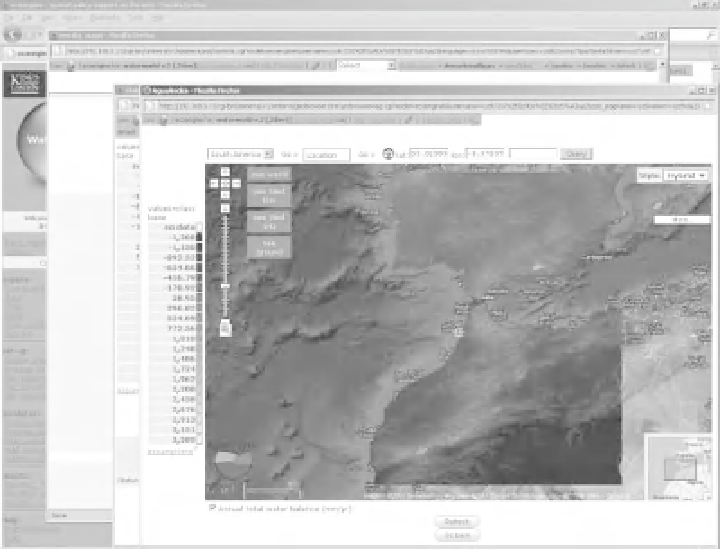
20.2.2 Thebaseline
Here we run a baseline simulation at 1 km
2
spatial res-
olution for the 10
◦
tile centred on coordinates 35
0
◦
N,
.
0
◦
W (covering southern Spain, Portugal, Morocco
and parts of Algeria). Figures 20.2 and 20.3 show typical
map output of water balance and erosion and give an
indication of the highly visual and dynamic nature of the
system. The system outputs some 32 variables as annual
average values and a further 14 variables monthly.
−
5
.
20.2.3 Scenarioanalysis (impactsof climate
change)
Here we use the previous simulation as the baseline for
a climate change scenario. A scenario to the PSS is an
outside influence on the system that is not under the
direct control of the decision maker. Climate-change
Figure 20.2
Annual total water balance, indicating areas of positive balance in the northern Mediterranean and mountainous regions
and areas of negative water balance (local actual evapo-transpiration maintained by flows from upstream and/or groundwater in S
Morocco and Algeria, Screenshot from WaterWorld, courtesy of King's College London and AmbioTEK).

Search WWH ::

Custom Search