Environmental Engineering Reference
In-Depth Information
damage caused by such disasters is dif
cult to
assess with extreme accuracy. We present here a
picture of few natural disasters that occurred in
this decade with special reference to their effect on
coastal vegetation.
F.1. Tsunami and Blue Carbon
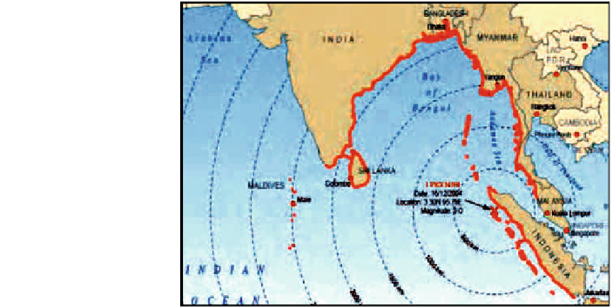
On 26 December 2004, a colossal shift of tec-
tonic plates triggered a magnitude 9.15 earth-
quake in the Indian Ocean, 150 km off the west
coast of north Sumatra, Indonesia (Fig.
7.9
).
The energy released caused the seabed to rise
by several metres, displacing an estimated 30 km
3
of water and triggering a series of devastating
tsunami waves. More than 230,000 people per-
ished, and millions were left destitute, as ten-
metre-high waves struck the coastlines across
13 countries. Among these 13 countries, maxi-
mum damages occurred in countries such as
Indonesia, Thailand, Sri Lanka and India. The
tsunami razed entire towns to the ground,
sweeping away buildings, bridges, cars, and, for
those that survived its impact, left behind shat-
tered livelihoods. The sheries sector was partic-
ularly badly hit: many thousands of
habitats, where still in existence, met the tsunami
head on. In doing so, they shielded lives and
property, but were also heavily impacted. Man-
groves and other littoral forests were in places
broken and uprooted, and coral reefs spectacularly
overturned, but in many cases, initial fears of
serious ecological damage were proved untrue.
One pattern that has consistently emerged, how-
ever, from post-tsunami environmental assess-
ments is that healthy ecosystems fared much
better and had a much greater protective function
than those denuded by human activities.
A preliminary assessment of the impacts of
the tsunami on the ecosystems of Aceh was
carried out by the Kuala Lumpur-based Global
Environment Centre at the request of the
Indonesian Ministry of Environment (Parish
and Lee
2005
). The GEC found that the ori-
ginal mangrove forests around Banda Aceh, the
capital of Aceh province, were cleared during
its development and converted to shrimp ponds.
When the tsunami hit Banda Aceh, houses built
on land that in the past had been sheltered by
mangroves were destroyed, and hundreds of
hectares of shrimp ponds were swallowed up
by the sea. Some pockets of mangroves had
survived development, but these were too small
to protect
shing boats
and gear were lost, and ports and other landing
sites destroyed. For coastal communities reliant
on farming, the tsunami ruined crops, drowned
livestock and poisoned arable land and water
supplies with salt. Mangroves and other coastal
the nearby houses (Parish and Lee
2005
).
Fig. 7.9
Route of
earthquake in the Indian
Ocean, 150 km off the west
coast of north Sumatra,
Indonesia
ARABIAN
SEA
BAY OF
BENGAL
ORIGIN
POINT
INDIAN
OCEAN