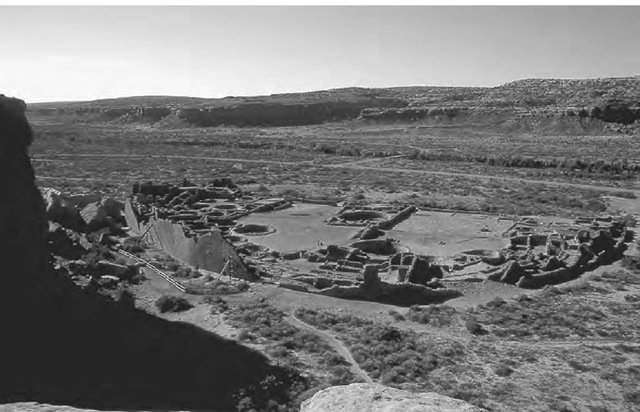
The sight of the Great Houses of Chaco Canyon—vast multistory constructions containing scores, and in a few cases hundreds, of rooms built in a dry and inhospitable valley—is nothing short of extraordinary. These and other architectural edifices were built by the ancient Puebloan peoples who occupied the canyon and the surrounding area between about c.e. 950 and 1125. The largest Great House, Pueblo Bonito, covers an area of 1.8 hectares (4.5 acres) and contains seven hundred rooms arranged in an irregular semicircle round a central plaza. The building increases in height from a single story by the plaza up to an incredible five stories next to the outer wall. In the plaza itself were numerous kivas—underground chambers built for religious ceremonies—of various sizes, including two “great kivas” around fifteen meters (fifty feet) across.
The extraordinary ruins of Pueblo Bonito in Chaco Canyon, viewed from the mesa top to the northwest.
The canyon has also been the focus for a variety of archaeoastronomical theories that, as much as anything, illustrate the changing focus of the discipline since its early development in the 1970s to the present day. For example, a hot issue in the 1970s was whether a rock-art pictograph painted on one of the canyon walls depicted a particular supernova explosion in c.e. 1054. Another discovery that attracted a great deal of popular attention was the “sun dagger”—an interplay of sunlight and shadow on two spiral pet-roglyphs high up on the isolated pinnacle of Fajada Butte at the eastern entrance to the valley. Finally, there have been the inevitable studies of orientations and alignments, which in the early days followed a paradigm that had been established in the context of British stone monuments: this was to search for alignments upon a predefined set of astronomical targets consisting of the horizon rising and setting positions of the sun at the solstices and equinoxes and of the moon at the lunar “standstills.”
These early approaches tended to be motivated more strongly by an interest in the nature of the astronomical practice itself than by an interest in the culture within which the practice operated. More recently, there has been a closer convergence between the questions asked by archaeoastronomers and the broader social issues of greater interest to archaeologists at large.
Archaeologically, one of the most intriguing questions about Chaco is why social organization and architectural technology should have reached such impressive heights in such an improbable place, and how they were supported. It is clear that a huge and well-organized infrastructure was needed, for example, in transporting tens of thousands of large timber beams for the construction of floors and roofs over distances of a hundred kilometers (sixty miles) or more from the nearest forests. A key issue is the size of the resident population. It seems unthinkable that the scant food sources available could have supported a population that filled all the rooms of the Great Houses, and this, together with other factors such as the preponderance of kivas, invites the suggestion that the canyon was first and foremost a religious center, with a relatively modest number of permanent residents. If so, then it was likely controlled by an elite who exerted both ideological and political control. One suggestion is that pilgrims are likely to have converged here in considerable numbers at particular times, and that these times would have been astronomically determined.
In recent years, convincing evidence has emerged that the houses, kivas, roads, stairways, and even middens around Chaco formed a carefully planned “ritual landscape” centered upon the Great Houses of the canyon itself. Within this scheme of things, it is perhaps not surprising that a number of buildings seem to have been deliberately oriented along one or the other of the cardinal directions, or else display a strong degree of symmetry about their north-south and/or east-west axes. Similar principles seem to have extended to the layout of buildings within the landscape, with several of the principal ones lying on an east-west axis and a north-south axis, which cross in the valley. When these axes were first discovered, many dismissed them as fortuitous rather than deliberate, but this changed with the subsequent discovery of the (Great) North Road, which connects with the north-south axis and runs due north from Chaco for more than fifty kilometers.
Astronomy, then, was part of the conceptual framework that lay behind the location and design of many of the principal Chaco constructions— at least on a basic level, since the north-south direction is ultimately defined in relation to the daily rotation of the celestial sphere about the celestial pole. This may not sound too exciting to a modern astronomer looking for astronomical “sophistication” (as defined in his or her own terms), but it is extremely interesting from a cultural perspective, because it suggests a degree of continuity of worldview extending down to the present day. The principles that defined the spatial layout of Chaco buildings and their landscape were apparently derived from a quadripartite cosmology—a perceived division of the world into four quarters around some central place. Such divisions have persisted as a characteristic feature of indigenous North American worldviews up to modern times.

