The fourth planet from the Sun, Mars is the first planet in the solar system beyond Earth. Compared with Earth, Mars is a small planet. With a value of 1.00 for Earth, the mass of Mars is 0.107; the density, 0.719; volume, 0.149. The equatorial diameter of Mars is 4,226 miles (6,772 kilometers) as compared with that of earth of 7,960 miles (12,757 kilometers). Although Mars has been observed since early times, reliable and detailed data did not become available until commencement of the Mariner exploratory program in the 1960′s. With the Viking programs of the last half of the 1970s, some important Mariner data had to be revised
The orbit of Mars is noticeably eccentric (0.093). The distance from Mars to the sun varies from a minimum of 129 million miles (208 million kilometers) at perihelion to a maximum of 155.3 million miles (249 million kilometers) at aphelion. Earth-bound observations of Mars are best when the planet is within a few months of opposition (when the Earth lies between the planet and the sun). During the remainder of the present century, Mars will be closest to earth on February 11, 1995, March 20, 1997, and May 1, 1999.
Mars has two satellites, or moons, Phobos and Deimos, both discovered in 1877 by Hall. Spacecraft have shown these bodies to be cratered, rocky, and chunky, and in recent years there has been serious speculation that these may not be moons in the usual sense, but rather captive asteroids. (See also Asteroids). Phobos is quite small, with dimensions of approximately 12.4 x 17.4 miles (20 x 28 kilometers) and Deimos even smaller, 6.2 x 9.9 miles (10 x 16 kilometers).
Missions to Mars. The twin Viking missions to Mars, each with its own lander, represented a very sophisticated and successful venture. Among some scientists there remains perplexity regarding some of the main features of the planet, notably numerous channels and rifts at one time called “canals” by
Earth-bound observers several decades ago. Knowledge of how these features look (including full-color) and their dimensions have been greatly enhanced, but the mysteries of their origins remains unknown. Earth-bound estimates and Mariner’s measurements of Mars comparatively thin atmosphere were confirmed, a factor which detracted from the possibility of organisms living on the planet. The polar ice cap once thought to be frozen carbon dioxide has been found to be ice with possibly some frozen carbon dioxide with it. Biological experiments designed to detect living organism proved negative, but the apparently oxidizing characteristic of Martian soil has introduced new puzzles.
An interesting view of Mars taken by Viking Orbiter 1 showing the huge Mariner Valley (Valles Marineris) is given in Fig. 1. A close-up of this extremely impressive Martian feature is given in Fig. 2.
The Viking missions are discussed in greater detail in a later section of this entry. Many missions preceded the Viking missions to Mars, and several have followed. The list below presents the chronology of missions to Mars:
Mars 1960A-USSR Mars Probe was launched on October 10, 1960, however, it failed to reach Earth orbit.
Mars 1960B-USSR Mars Probe. Launched on October 14, 1960. It also failed to reach Earth Orbit.
Mars 1962A-USSR Mars Flyby. Launched on October 24, 1962, this spacecraft failed to leave Earth orbit after the final rocket stage exploded.
Mars 1— USSR Mars Flyby. Launched on November 1, 1962. The spacecraft weighed 1,969 pounds (893 kilograms). This mission was not successful due to communications failure.
Mars 1962B- USSR Mars lander. Launched on November 4, 1962.
This spacecraft also failed to leave Earth orbit.
Mariner 3 — Launched on November 5, 1964 at a weight of 572 pounds (260 kilograms) by the USA, the solar panels did not open, preventing a successful flyby. Mariner 3 remains in solar orbit.
Mariner 4 — Launched on November 28, 1964 at a weight of 572 pounds (260 kilograms) by the USA, Mariner 4 reached Mars on July 14,1965. It passed within 5,952 miles (9,920 kilometers) and returned data confirming that the atmosphere was composed of carbon dioxide, and identifying a small magnetic field. Mariner 4 obtained 22 close-up photos of the surface of Mars clearly showing surface features, notably craters. Mariner 4 remains in solar orbit.
Zond 2—USSR Mars Flyby launched on November 30, 1964, which was unsuccessful. Contact with the spacecraft was lost and its fate is unknown.
Mariner 6— USA Mars Flyby launched at a weight of 910 pounds (413 kilograms), the spacecraft reached Mars on July 31, 1969. It passed within 2,062 miles (3,437 kilometers) of the surface of the planet. Mariner 6 remains in solar orbit.
Mariner 7—USA Mars Flyby launched at a weight of 910 pounds (413 kilograms), the spacecraft reached Mars on August 5, 1969. It passed within 2,131 miles (3,551 kilometers) of the surface of Mars at the south pole region. Both Mariner 6 and Mariner 7 obtained data related to the atmosphere and surface composition. Over 200 photos were obtained during these two missions. Mariner 7 remains in solar orbit. See Fig. 4.
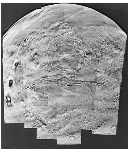
Figure 1. Mosaic of 102 photos of Mars taken op February 22,1980 by Viking Orbiter 1. Several prominent Martian features and at least two unusual weather phenomena are visible. Valles Marineris (Mariner Valley), as long as the North American continent from coast to coast, stretches across the center. Three huge volcanoes of the Tharsis Ridge are visible at the left: Arsia Mons, Pavonis Mons, and Ascraeus Mons, proceeding from south to north. A sharp line, either a weather front or an atmospheric shock wave, curves north and east from Arsia Mons. This is the first time a feature like this had been seen on a planet. Four tiny clouds can be seen in the southernmost frame, just north ofa large crater named Lowell. While the clouds are too close together to be resolved, even under high magnification, their shadows can be separated easily. The largest cloud is nearly 32 kilometers (20 miles) long. Measurements show the elevation of the clouds at nearly 28 kilometers (91,000 feet). Such distinct cloud-shadow patterns apparently are quite rare on Mars.
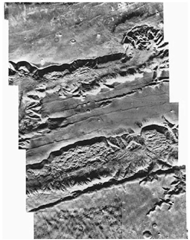
Figure 2. Mosaic of the surface of Mars showing the west end of the Valles Marineris (all of which is shown in Fig. 1) from a range of about 4300 kilometers (2700 miles). These two canyons, running east-west across the picture, are each about 60 kilometers (37 miles) wide and more than 1 kilometer (0.6 mile) deep. Some scientists suggest that the canyons were originally formed by downfaulting of the crust along parallel faults. Other faults and collapsed depressions with the same trend are seen between the two canyons. After they were formed, it is suggested that the canyons were modified by erosion that formed great slumps on the walls and also cut side valleys to the main canyons. A few comparatively recent impact craters will be noted, particularly at the bottom right of the view.
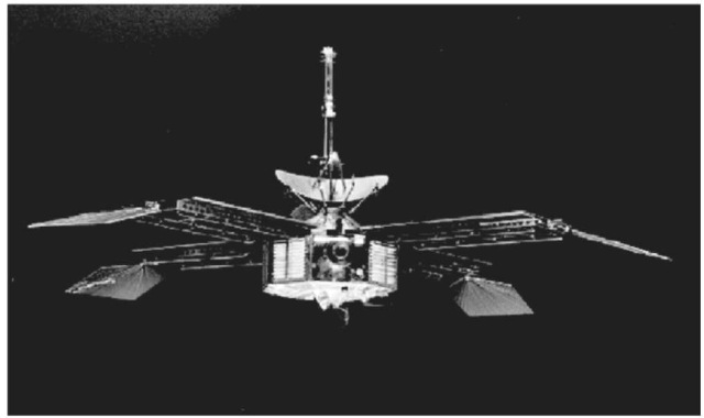
Figure 3. Mariner 4 was the fourth in a series of spacecraft used for planetary exploration in a flyby mode. It was designed to conduct close-up scientific observations of the planet Mars and to transmit these observations to Earth.
Mariner 8 — USA Mars Flyby launched May 8, 1971, this mission was unsuccessful as it failed to reach Earth’s orbit.
Kosmos419—Launched by the USSR May 10, 1971, this mission was unsuccessful as it failed to reach Earth’s orbit.
Mars 2—This spacecraft was a USSR Mars Orbiter/Soft Lander launched May 19, 1971 that weighed 10,230 pounds (4,650 kilograms). It failed in its landing mission as the Mars 2 Lander, which was released from the Orbiter on November 27, 1971, crash-landed on the surface of the planet. It is known that the breaking rockets failed, but no data was returned. The Mars 2 Orbiter returned data until 1972.
Mars 3 — This spacecraft was another USSR Mars Orbiter/Soft Lander that weighed 10,215 pounds (4,643 kilograms). It reached Mars on December 2, 1971, and successfully released the lander to the surface of the planet. It was the first successful landing on the surface of Mars, but the Mars 3 failed to record and transmit more than 20 seconds of data to the orbiter. The Mars 3 arbiter collected data related to the surface temperature and atmospheric conditions until August 1972.
Mariner 9—Launched by the USA May 30, 1971, the spacecraft weighed 1,116 pounds (506 kilograms). Mariner 9 was the first US spacecraft to enter orbit around a body other than the Earth’s moon, and it entered this orbit on November 24, 1971. Among the data obtained were the first high-resolution images of the Martian moons, Phobos and Deimos, and surface data detailing river and channel-like features. Mariner 9 remains in Martian orbit. See Fig. 5.
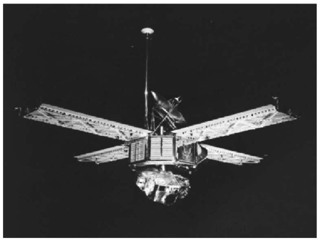
Figure 4. Mariner 6 and 7 were designed to fly over the equator and southern hemisphere of the planet Mars. They were solar powered and capable of continuous telemetry transmission. Each spacecraft weighed 910 pounds (413 kilograms) and measured 11 feet (3.35 meters) from the scan platform to the top of the low-gain antenna. The width across the solar panels was 19 feet (5.8 meters). The eight-sided body of the spacecraft carried seven electronic compartments. A small rocket engine, used for trajectory corrections, protruded through one of the sides. The planetary experiments aboard the spacecraft were two television cameras, an infrared radiometer, and infrared spectrometer and as ultraviolet spectrometer.
Mars 4—Another of the USSR Mars Orbiter/Soft Lander vehicles, this mission was not wholly successful. Although it arrived at Mars in February 1974, it failed to enter orbit due to failure of the braking rockets. A flyby at a distance of 1,320 miles (2,200 kilometers) returned limited data.
Mars 5—A USSR Mars Orbiter/Soft Lander vehicle, the spacecraft weighed 10,230 pounds (4,650 kilograms) and entered Martian orbit in February 1974. Data obtained during this mission set the stage for the Mars 6 and Mars 7 missions.
Mars 6— This USSR Mars Orbiter/Soft Lander vehicle, which weighed 10,230 pounds (4,650 kilograms) entered Martian orbit on March 12, 1974 and launched its lander. The lander successfully transmitted atmospheric data during its descent, but failed prior to landing.
Mars 7— Another USSR Mars Orbiter/Soft Lander vehicle that weighed 10,230 pounds (4,650 kilograms), failed both to enter Martian orbit and to set the lander vehicle on the Martian surface. The Mars 7 orbiter and lander remain in solar orbit.
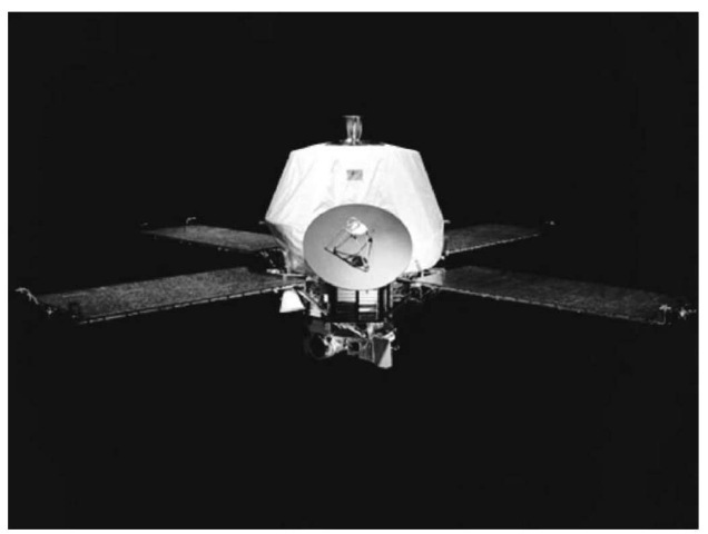
Figure 5. The Mariner 9 spacecraft was built on octagonal magnesium frame 18 inches (45.7 centimeters) deep and 54.5 inches (138.4 centimeters) across a diagonal. Four solar panel each 85 x 35 inches (215 x 90 centimeters), extended out from the top of the frame. Each set of two solar panels spanned 23 feet (6.89 meters) from tip to tip. Also mounted on the top of the frame were two propulsion tanks, the maneuver engine, a 5-foot (1.44 meters) long low gain antenna mast and a parabolic high gain antenna. A scan platform was mounted on the bottom of the frame, on which were attached the mutually bore-sighted science instruments (wide-and narrow-angle TV cameras, infrared radiometer, ultraviolet spectrometer, and infrared interferometer spectrometer). The overall height of the spacecraft was 7.5 feet (2.28 meters).
Viking 1 — Designed after the Mariner spacecraft, the USA Mars Lander/ Orbiter was launched on August 20, 1975 weighing 7,478 pounds (3,399 kilograms). The orbiter weighed 1,980 pounds (900 kilograms) and the lander weighed 1,320 pounds (600 kilograms). Viking 1 entered Martian orbit June 19, 1976, and its lander successfully set on the surface one day later on July 20, 1976 on the western slopes of Chryse Planitia. The lander and orbiter obtained data related to the weather on Mars, the Martian terrain, and microorganisms on the planet. The Viking 1 orbiter ran out of altitude control propellant August 7, 1980 and was deactivated. The Viking 1 lander was accidentally shut down and neither communication nor activation was ever regained. See Fig. 6.
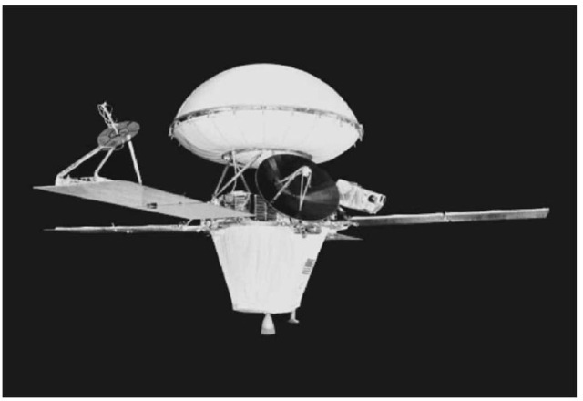
Figure 6. This image shows a model of one of the Viking spacecraft, which were made of two parts: an orbiter and a lander. The orbiter’s initial job was to survey the planet for a suitable landing site. Later the orbiter’s instruments studied the planet and its atmosphere, while the orbiter acted as a radio relay station for transmitting lander data.
Viking 2—Also designed after the Mariner spacecraft, the USA Mars Land-er/Orbiter was launched on September 9, 1975 weighing 7,478 pounds (3,399 kilograms). See Fig. 7. The orbiter weighed 1,980 pounds (900 kilograms) and the lander weighed 1,320 pounds (600 kilograms). Viking 2 entered Martian orbit on July 24, 1976 and its lander set down at Utopia Planitia on August 7, 1976. See Fig. 8. While both landers had experiments to search for and identify microorganisms on Mars, the results of the experiments are still subject to debate. Both landers together obtained over 52,000 images while mapping the planet’s surface. The Viking 2 orbiter ran out of altitude control propellant July 25, 1978 and was deactivated. Because the Viking 2 lander used the Viking 1 orbiter for communications, it had to be shut down the same time the Viking 1 orbiter was deactivated on August 7, 1980.
Phobos 1— USSR Mars Obiter/Lander weighing 11,000 pounds (5,000 kilograms) that was launched on July 7, 1988. The spacecraft was lost on the way to Mars due to a command error on September 2, 1988. See Fig. 9.
Phobos 2 — USSR Phobos Flyby/Lander, which weighed 11,000 pounds (5,000 kilograms), was launched on July 12, 1988. The spacecraft entered Martian orbit January 30, 1989, but failed at a distance of 480 miles (800 kilometers) from the Martian moon Phobos.
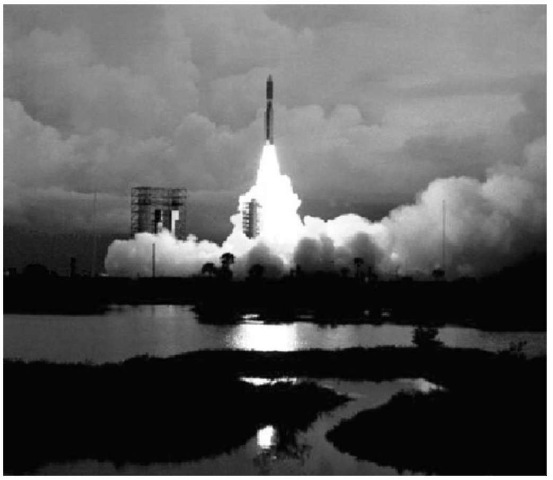
Figure 7. Launch of the Viking 2 spacecraft from Cape Canaveral, Florida.
Mars Observer—USA Mars Orbiter was launched September 25, 1992 but failed to enter Martian orbit. Communication with the Mars Observer was lost August 21, 1993.
Mars Global Surveyor—USA Mars Orbiter was launched November 7, 1996 to complete the mission of the Mars Observer.
Mars 96—Russia Orbiter and Lander which was launched November 16, 1996, consisted of an orbiter, two landers and two soil penetrators. The fourth stage of the rocket that launched the Mars 96 spacecraft ignited prematurely as the vehicle entered orbit. The spacecraft crashed into the ocean and sank between the coast of Chile and Easter Islands.
Mars Pathfinder— USA Lander and Surface Rover launched on December 4, 1996. The lander weighed 581 pounds (264 kilograms) and the rover vehicle weighed only 23 pounds (10.5 kilograms). Mars Pathfinder reached Mars July 4, 1997 and impacted the surface at a velocity of approximately 40 miles per hour (18 meters per second).
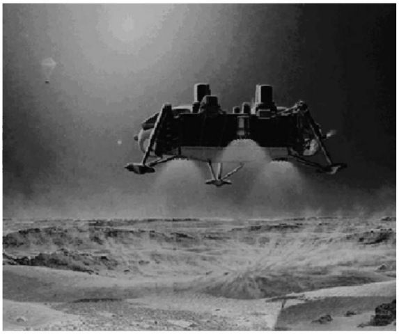
Figure 8. Captured in this rendering is a Viking lander just before it touched down on the Martian surface. The parachute and upper aeroshell can be seen in the upper left corner of the image. At this stage of the descent, the lander’s terminal descent propulsion system (three retro-engines) had slowed the craft down so that velocity at landing was about 7 miles per hour (2 meters per second). Seconds after the lander reached the surface it began transmitting images back to the orbiter for relay to Earth.
It bounced into the air about 50 feet (15 meters), bounced another 15 times, and rolled to a stop approximately 2.5 minutes after impact about one-half mile (about 1 kilometer) from the site of initial impact. The landing site, in the Ares Valley region at 19.33 °N, 33.55 °W, was named the Sagan Memorial Station. The rover, a six-wheeled vehicle named Sojourner, hit the Martian surface July 6. See Figs. 11 and 12. This highly successful mission returned 2.6 billion bits of information including over 16,000 images from the lander, 550 images from So-journer, 15 chemical analyses of rocks, and extensive data on climatic conditions. (See also Pathfinder Mission to Mars).
Nozomi. Launched on July 3, 1998, by Japan’s Institute of Space and As-tronautical Sciences, it will be the first Japanese spacecraft to reach another planet. Nozomi will study Martian aeronomy, particularly Mars’ upper atmosphere, ionosphere, and their interactions with the solar wind. The spacecraft will reach Mars and go into orbit in December 2003.
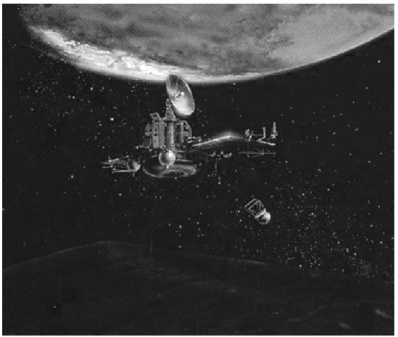
Figure 9. This artist’s concept depicts the Phobos 1 & 2 spacecraft destined for Mars. They were the next-generation in the Venera-type planetary missions, succeeding those last used during the Vega 1 and 2 missions to comet P/Halley.
Mars Climate Orbiter. Launched on December 11, 1998, to embark on a study of the planet’s climate, daily weather and current water resources. On September 29, 1999, the spacecraft was lost due to a navigational error as it entered the atmosphere of Mars (See Figure 13).
Mars Polar Lander. Launched on January 3, 1999, and targeted for a landing zone near the edge of the South Polar-layered terrain. The spacecraft was designed to search for near surface ice and possible records on the surface of cyclic climate and geophysical changes. The spacecraft was lost on arrival at Mars on December 3, 1999 (See Figure 14).
NASA Unveils Its 21st Century Mars Campaigns
The seven-month retooling of its Mars campaign was prompted by the back-to-back loss last year of two spacecraft at the Red Planet. Subsequent investigative reports, including one authored by retired Lockheed Martin executive Tom Young, found bad management, a lack of training and an inadequate system of checks and balances, as well as too-tight budgets, doomed the Mars Climate Orbiter and Polar Lander missions, a $300 million-plus loss.
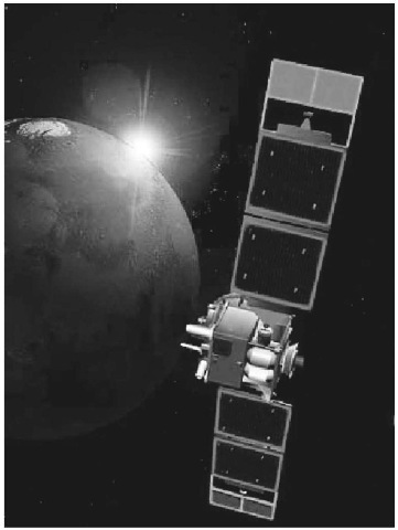
Figure 10. Captured in this rendering the Mars Global Surveyor (MGS) is designed to orbit Mars over a two year period and collect data on the surface morphology, topography, composition, gravity, atmospheric dynamics, and magnetic field. These data will be used to investigate the surface processes, geology, distribution of material, internal properties, evolution of the magnetic field, and the weather and climate of Mars.
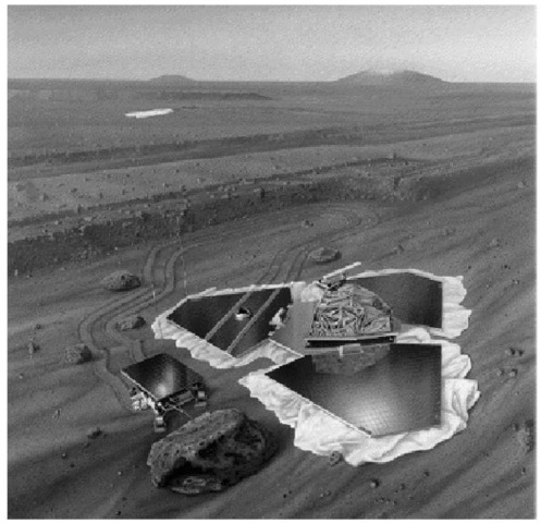
Figure 11. Artist view of Pathfinder on Mars.
NASA halted ambitious plans to send a lander/orbiter pair to Mars every 26 months, when the Earth and the Red Planet are closely aligned. Instead, it will now stagger the pace dispatching just one of each at the roughly two-year intervals.
The revised program also looks out beyond returning a sample of Martian soil to Earth for study. That goal has been pushed back to 2011 or later.
This program will represent a long-term strategy. It won’t just end with Mars sample return like the previous one did. Officials, said the new program, allows for NASA to respond to any new discoveries on Mars, like the evidence that suggests water may have flowed on the planet’s surface in the recent past, as well as accommodate the prospect of any of the planned missions failing.
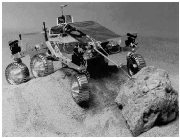
Figure 12. The rover Sojourner is a six-wheeled vehicle launched with the Mars Pathfinder mission. It is controlled by an Earth-based operator, who uses images obtained by both the rover and lander systems. Note that the time delay is about 10 minutes, requiring some autonomous control by the rover. The primary objectives were scheduled for the first seven sols (1 sol — 1 martian day — ~24.7).
What’s missing from the equation are humans. NASA has already scrapped plans to launch in 2001, a package of experiments that would have laid some of the groundwork for future human missions to Mars, including experiments to produce oxygen from the Martian atmosphere and to assess the threat of its dust and radiation environments. Now, similar experiments might not make to Mars until 2007 at the earliest.
The agency plans on six major Mars missions for this decade alone, spending as much as $450 million a year on its near-term efforts. The missions include: 2001 — Mars Surveyor Lander 2001. This program was canceled as part of the reorganization of the NASA Mars exploration program described previously. However, elements of the original program will be used on future missions. The orbiter, renamed Mars Odyssey, will nominally orbit Mars for three years, with the objective of conducting a detailed mineralogical analysis of the planet’s surface from orbit and measuring the radiation environment. The mission has as its primary science goals to gather data to help determine whether the environment on Mars was ever conducive to life, to characterize the climate and geology of Mars, and to study potential radiation hazards to possible future astronaut missions. The orbiter will also act as a communications relay for future missions to Mars over a period of five years. Eventually, a follow-on mission with a Lander named Marie Curie will also be flown. 2003—Two water-sniffing Mars Exploration Rovers, for detailed field geological work.
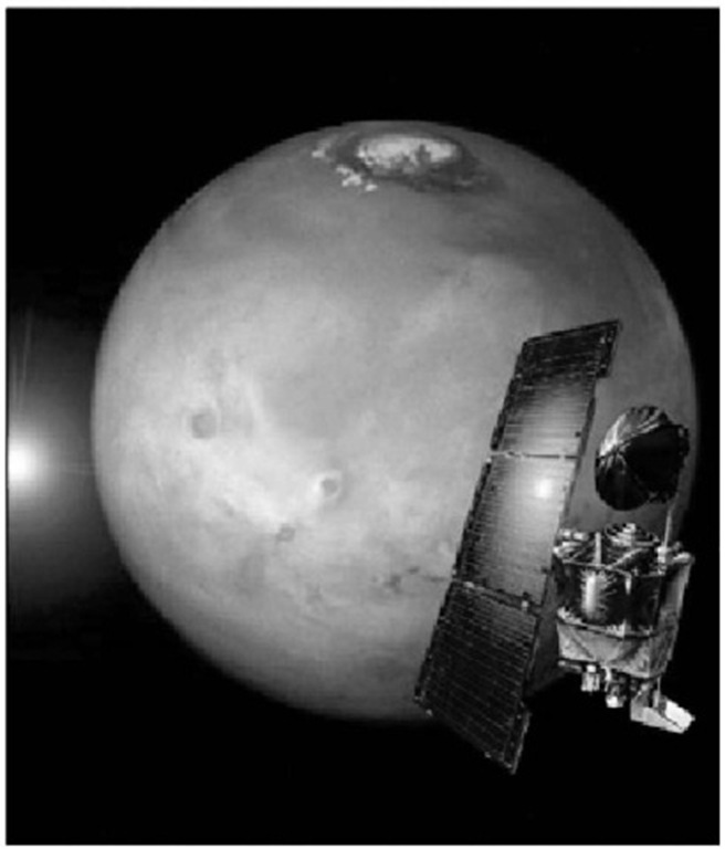
Figure 13. The Mars Climate Orbiter Spacecraft was launched from Cape Canaveral on December 11, 1998. It was lost on September 29, 1999, due to a navigational error. The intention was to place the spacecraft in a highly elliptical orbit around Mars and then to lower the periapsis into the upper atmosphere of Mars. The spacecraft would then use aerobraking to circularize the orbit before initiating science operations. Using this maneuver makes it possible to save substantial fuel and therefore spacecraft weight.
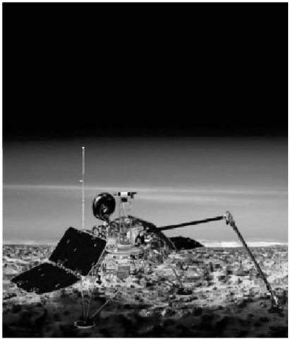
Figure 14. The Mars Polar Lander Spacecraft was launched from Cape Canaveral on January 3, 1999. The spacecraft was lost on December 3, 1999, during Mars orbit insertion. The payload included instruments for sampling soil at the surface and also within one meter of the surface. In addition, there was a stereoscopic camera and also meteorological sampling equipment.
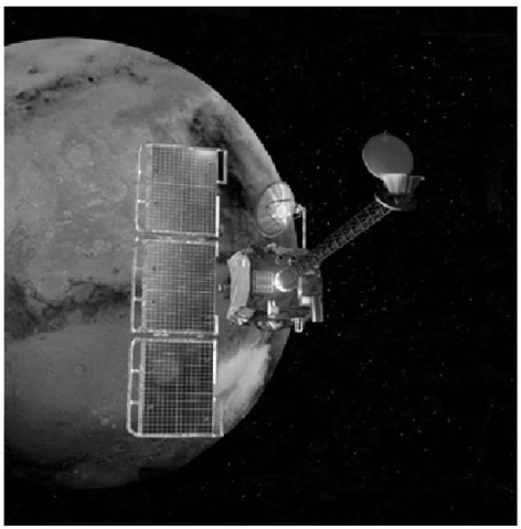
Figure 15. The Mars Odyssey spacecraft was originally part of the Mars Surveyor Lander 2001 plan that was canceled. The Odyssey will be the first to use the atmosphere of Mars to slow down and directly capture a spacecraft into orbit in one step, using a technique called aerocapture. It will then reach a circular mapping orbit within about 1 week after arrival. The Odyssey will carry 2 main science instruments, the Thermal Emission Imaging System (THEMIS) and the Gamma Ray Spectrometer (GRS). THEMIS will map the mineralogy and morphology of the Martian surface using a high resolution camera and a thermal infrared imaging spectrometer. The GRS will achieve global mapping of the elemental composition of the surface and the abundance of hydrogen in the shallow subsurface. The gamma ray spectrometer was inherited from the lost Mars Observer mission.
2005—A Mars Reconnaissance Orbiter: an orbiter modeled on NASA’s successful Mars Global Surveyor, but capable of imaging objects as small as 30 centimeters (a foot) in diameter. Jim Garvin, NASA’s Mars exploration program scientist, likened it to putting a microscope in orbit.
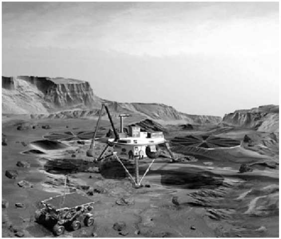
Figure 16. The Mars Surveyor Lander 2001. This spacecraft was part of the canceled program already mentioned in the caption for Figure 15. It is likely to be used eventually in a future NASA Mars exploration flight. The Lander will carry an imager to take pictures of the surrounding terrain during its’ rocket-assisted descent to the surface. The descent imaging camera will provide images of the landing site for geologic analyses, and will aid planning for initial operations and traverses by the rover. The Lander will also be a platform for instruments and technology experiments designed to provide key insights to decisions regarding successful and cost-effective human missions to Mars. Hardware on the Lander will be used for an in-situ demonstration test of rocket propellant production using gases in the Martian atmosphere. Other equipment will characterize the Martian soil proper and surface radiation environment.
2007—A ”smart” surface lander equipped with a hazard avoidance system, precision landing capability and designed to deliver a rover laden with up to 270 kilograms (600 pounds) of scientific instruments; also in 2007, a ”Scout” mission, which could entail a small Beagle 2-type lander, a balloon or an airplane. Both balloon and airplane Mars missions have been submitted as proposals in the current round of Discovery-class NASA projects.
The Mars Pathfinder landing in 1997 was within a 100 x 300-kilometer (60 x 200-mile) landing ellipse. “Where we want to be by 2007 is down to some-thing that’s 1 kilometer by 3 kilometers (0.62 by 2 miles) — a reduction by a factor of 100,” Lavery said. The eventual goal is to land spacecraft on the equivalent of a Martian dime—within a tight ellipse just a few hundreds of yards (meters) across, he said.
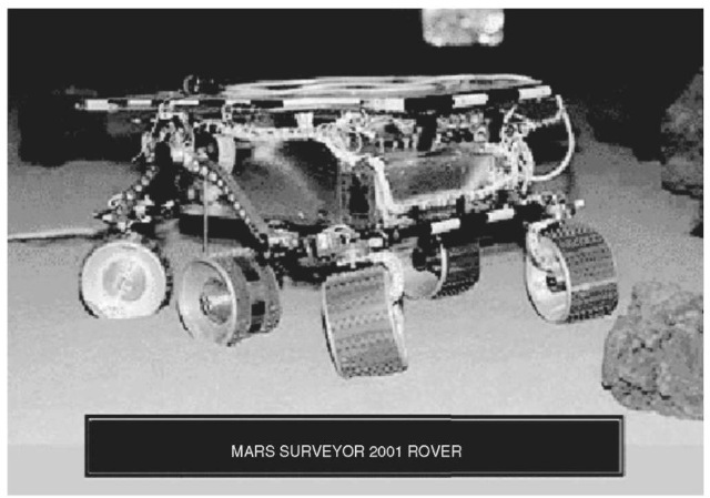
Figure 17. As part of the Mars exploration mission redesign, the plans for this rover have changed significantly. Current plans are to send the Marie Curie rover to Mars on a future lander. This rover is very similar to the Pathfinder Sojoumer Rover, and in fact is the same rover that was used within the Pathfinder “sandbox” test bed pictured above.
2007—NASA could also kick off an international collaborative effort in 2007, teaming up with the Italian space agency on a telecommunications orbiter for Mars or with the French on a network of small landers.
2009—NASA could team up again with the Italians on a follow-on to the European Space Agency’s 2003 Mars Express mission. The probe would carry ground-penetrating radar to prospect for water on the Red Planet.
2011—As early as 2011, but perhaps slipping to 2014, NASA could start a long-term project to return multiple samples of Martian soil and rock to Earth. The effort, which could cost as much as $2 billion a pop, had been on tap for 2005 under the previous plan.
The Martian Atmosphere
As pointed out by Anders and Owen (1977), the thinness of the Martian atmosphere has been one of the great disappointments of the space age. At one time,Lowell, Dollfus, and others had suggested a surface pressure near 80 millibars (1 standard atmosphere on earth = 1013 millibars). Even with an atmosphere only about one-tenth the value of earth’s, it was envisioned that Mars possibly could sustain some forms of life. Viking 1 established a figure of 7.65 millibars. Substantiation of this relatively low pressure, indicating that Mars has only about 3% of the volatiles found on earth, revised scientific thinking in terms of the development of Mars. Anders and Owen suggested five processes, in combination, which may have been responsible for the thin martian atmosphere: (1) a small initial endowment of volatiles; (2) incomplete outgassing from the interior; (3) recondensation or trapping in surface regions; (4) catastrophic loss of an early atmosphere; and (5) gradual escape of the lighter constituents. Although these investigators do not describe a detailed model for how the Martian atmosphere passed from an early, dense state to its present condition, they offer a schematic scenario:
The basic notion is that the atmosphere gradually decreased in density as a result of the deposition of carbon dioxide in the form of carbonates and the escape of nitrogen from the upper atmosphere. While the latter process was critical for the ultimate nitrogen abundance and isotope ratio, it should have played a small role in determining the total atmospheric pressure, since carbon dioxide was probably the most abundant gas. The depositional process (which may have included formation of nitrates or nitrites) was most active during the time when liquid water was most abundant—the cutting of the sinuous channels was thus a premonition of the end of the dense atmosphere. The apparent absence of an active Martian biota has prevented the recycling of volatiles through biological processes. Moreover, there is evidence that carbonates may form even under the present arid conditions on Mars.
Anders and Owen proceed in their interesting paper to make comparisons between the large and the small planets, with earth and Mars as paradigms. Water and Water Vapor. An infrared spectrometer operating at the 1.38. micrometer region, mounted on the scan platform, was used to detect water vapor in the Martian atmosphere.1 This scanning device was used to measure the latitudinal variations and diurnal variations. By operating over a complete martian year, the instrument was able to measure the seasonal changes. The southern hemisphere, which was at the onset of winter, was found to have very little water vapor (0 to 0.3 precipitable micrometer). In contrast, the northern hemisphere showed a significant amount of water (up to 75 micrometers at 7080 °N), a range of almost three orders of magnitude. The north polar region showed a slight drop in water vapor abundance. A strong diurnal repetitive cycle in certain regions, peaking out in the local mid-afternoon, was also found. Negative correlation existed between the elevation and the water vapor abundance, as would be expected. On the basis of the abundance of water vapor in the polar region, a lower limit can be put on the atmospheric temperature, namely 205 K (— 68 °C; — 90 °F). This value indicates that the permanent polar cap consists of water ice, a factor that was confirmed by the infrared thermal mapper (IRTM) also part of the Viking instrumentation package.
Observations of the latitude dependence of water vapor made from the Viking 2 Orbiter showed peak abundances in the latitude band 70-80 °N in the northern midsummer season. Total column abundances in the polar regions appeared to require near-surface atmospheric temperatures in excess of 200 K (— 73 °C: — 99 °F) and are incompatible with the survival of a frozen carbon dioxide cap at martian pressures. The remnant or residual on the north polar cap and the outlying patches of ice at lower latitudes are thus believed to be predominantly water ice whose thickness can be established within widely spaced limits, between 1 meter and 1 kilometer (~3 and 3280 feet). Broadband thermal and reflectance observations of the Martian north polar region in late summer yielded temperatures for the residual polar cap near 205 K (— 68 °C; — 90 °F). Residual cap and several outlying smaller deposits appeared to be water ice with included dirt. No evidence was found for a permanent carbon dioxide polar cap.
The first evidence of the direct visible exchange of water between the martian surface and atmosphere was obtained by the Viking 1 Orbiter on July 24, 1976, as shown by Fig. 18.
Ground Ice on Mars. As reported by Squyres (NASA Ames Research Center) and Carr (U.S. Geological Survey), many martian landforms suggest the former presence of ground ice or water, including fretted and chaotic terrain, valley systems, outflow channels, and, with less certainty, various types of patterned ground and rampart craters. If sufficient ice is present now, the regolith should undergo quasi-viscous flow due to creep deformation of the ice. Accordingly, to determine where ice may be present, the researchers examined approximately 24,000 Viking Orbiter images taken within 5000 km of the surface and mapped the distribution of three types of features—lobate debris aprons, concentric crater fill, and terrain softening—that may indicate creep of near-surface materi-als.2 In summary, the researchers observe that the origin of ice in the martian regolith is unclear at this time. The many lines of evidence implying that ice was common in the cratered uplands early in Martian history suggest that the ice was emplaced during an early period of intense outgassing. An alternative scenario would be the continuous outgassing throughout the planet’s history at a rate substantially lower than the low-latitude depletion rates in order to keep the low latitudes ice-free. In either case, intense early meteoritic brecciation was probably largely responsible for the apparent capability of the deep regolith to hold large amounts of water.
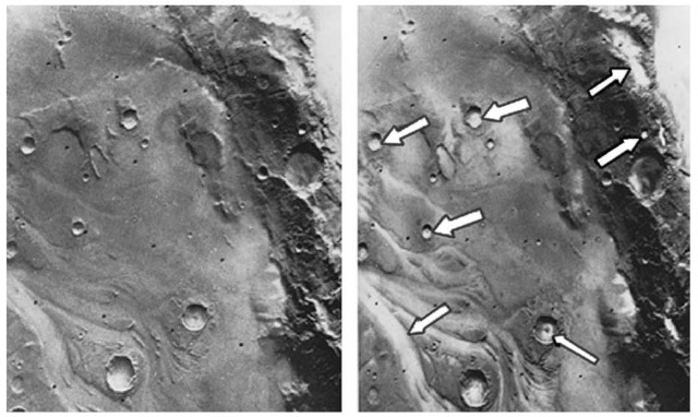
Figure 18. Two pictures taken a half-hour apart by Viking 1 Orbiter shows the development on Mars of early morning fog in low spots, such as crater and channel bottoms (see arrows on view at right). The scene at left was photographed shortly after martian dawn on July 24, 1976 from 12,400 kilometers (7700 miles) and, at right, 30 minutes later from 9800 kilometers (6100 miles). Slight warming of the sub-zero surface by the rising sun evidently drove off a small amount of water vapor which recondensed in the colder air just above the surface. Brightness measurements of the resulting fog patches indicated that a film of water about one micrometer thick had condensed. These fog patches were the first direct, visible evidence as to where the exchange of water between the martian surface and atmosphere may occur.
Juvenile Water from Volcanism. In studying Viking data. Greeley (Arizona State University) reports that volcanism played a dominant role in the evolution of the Martian surface and environment. It is estimated that volcanism has occurred from at least the close of the period of heavy impact cratering (~3.9 billion years ago) to the age of the youngest rocks visible on the planet. Materials that are considered to be of volcanic origin cover more than half the surface of Mars. Perhaps the assumption can be made that, as with the Earth, juvenile water3 was released on Mars in association with the eruption of these volcanic materials. By determining the volumes and ages of volcanic units and inferring the volatile content for the magmas, the amounts and timing of associated water release can be estimated. Tentative conclusions indicate the amount of juvenile water release on Mars would equal a layer some 46 meters deep over the entire planet. Most of this water was released in the first 2 billion years of Martian history. There are several uncertainties in estimates made to date, including lack of knowledge of volatile contents for magmas; even terrestrial values, as used, have large uncertainties, and extrapolation to martian values is difficult. Uncertainties that stem from estimates of volcanic unit volumes can be reduced through more detailed mapping and determination of flow thicknesses, which will include additional new data, obtained from the Mars Observer in the 1990s. Carbon Dioxide. At both Viking landing sites, it was found that the temperature was appreciably above the carbon dioxide condensation boundary, thus precluding the occurrence of carbon dioxide hazes in northern summer at latitudes at least 50 °N. Thus, the ground level mists seen in these latitudes would appear to be condensed water vapor. Neutral mass spectrometers carried on the aeroshells of both Viking spacecraft indicated that carbon dioxide is the major constituent of the martian atmosphere over the height range of 120 to 200 kilometers (74 to 124 miles). Densities for carbon dioxide measured by the upper atmospheric mass spectrometers on both Viking spacecraft were analyzed to yield height profiles for the temperature of the Martian atmosphere between the aforementioned range. The upper atmosphere of Mars was found to be surprisingly cold with an average temperature of less than 200 K (— 73 °C; — 99 °F). The atmosphere contains detectable concentrations of nitrogen, argon, carbon dioxide, molecular oxygen, atomic oxygen, and nitric oxide. The upper atmosphere exhibits a complex and variable thermal structure and is well mixed to heights in excess of 120 kilometers (74 miles).
Carbon Dioxide and Heat Balance at Polar Caps. As reported by Paige and Ingersoll (California Institute of Technology), the Infrared Thermal Mappers (IRTM) aboard the two Viking orbiters obtained solar reflectance and IR emission measurements of the martian north and south polar regions during an entire martian year. The observations were used to determine annual radiation budgets and to infer annual carbon dioxide frost budgets. The results provide further confirmation of the presence of permanent CO2 frost deposits near the south pole and show that the stability of these deposits can be explained by their high reflectivities. In the north, the observed absence of solid CO2 during summer was primarily the result of enhanced CO2 sublimation rates due to lower frost reflectivities during spring. The results suggest that the present asymmetric behavior of CO2 frost at the Martian poles is caused by preferential contamination of the north seasonal polar cap by atmospheric dust. The investigators emphasize that the Viking results have made it clear that the annual heat balance at the Martian poles is not purely a local phenomenon, but may be strongly influenced by the complex, global scale geologic and atmospheric processes that bring dust to the polar regions each year. The forthcoming Mars Observer mission, which will follow a polar orbit about the planet, will furnish much needed additional data.
Nitrogen. Results from the neutral mass spectrometer carried on the aeroshell of Viking 1 spacecraft showed evidence for NO in the upper atmosphere of Mars and indicated that the isotopic composition of carbon and oxygen is similar to that of earth. Mars is enriched in 15N relative to Earth by about 75%, a consequence of escape that implies an initial abundance of nitrogen equivalent to a partial pressure of at least 2 millibars. The initial abundance of oxygen present either as carbon dioxide or water must be equivalent to an exchangeable atmospheric pressure of at least 2 bars in order to inhibit escape-related enrichment of 18O. McElroy, Yung, and Nier (1976) constructed models for the past history of nitrogen on Mars based upon Viking measurements showing that the atmosphere is enriched in 15N. The enrichment is attributed to selective escape, with fast atoms formed in the exosphere by electron impact dissociation of N2 and by dissociative recombination of . The initial partial pressure of N2 should have been at least as large as several millibars and could have been as large as 30 millibars if surface processes were to represent an important sink for atmospheric HNO2 and HNO3.
Krypton and Xenon. These gases were discovered in the Martian atmosphere with the mass spectrometer on Viking Lander 2. Krypton is more abundant than xenon. The relative abundances of the krypton isotopes appear normal, but the ratio of xenon-129 to xenon-132 is enhanced on Mars relative to the Earth value for this ratio. The mass spectrometer on Viking Lander 1 had previously reported the detection of 36Ar and the establishment of upper limits on Ne, Kr, and Xe in the atmosphere. The upper limit of krypton was close the value that would be predicted if the 36Ar/Kr ratio on Mars were identical to that on Earth. As pointed out by Owen et al. (1976), the Earth’s atmosphere is deficient in xenon compared with the primordial gas in meteorites, and this is exactly the situation found on Mars. The xenon deficiency on Earth has been attributed to the preferential adsorption of xenon in shales and other sedimentary material after it was out-gassed. One is thus led to the tentative conclusion that similar processes have been active on Mars, perhaps in association with the epochs of fluvial erosion that have left their imprint on the planet’s surface. Owen et al. suggest as an alternative or supplementary suggestion that some of the xenon could be absorbed in the regolith.
Weather
The atmosphere of Mars appears to favor stability, much unlike Earth in that regard. The annual temperature range for the Martian surface at the Viking landing sites was computed on the basis of thermal parameters derived from observations made with infrared thermal mappers. Viking Lander 1 site showed small annual variations in temperature, whereas VL-2 site showed larger annual changes. (Locations of the sites are described in the latter portion of this article.) At both sites, daily temperature ranges at the top of the soil were 183 to 268 K (— 90 to — 5°C; — 130 to + 23 °F). Diurnal variations decreased with depth in an exponential manner. The maximum temperature of soil sampled beneath rocks at the VL-2 site was computed to be 230 K (— 43 °C; — 45 °F). Daily patterns of temperature, wind, and pressure were highly repetitive at both sites during the early summer period. Wind was found to have a vector mean of 0.7 meter/second from the southeast with diurnal amplitude of 3 meters/second. Pressure exhibited both diurnal and semidiurnal oscillations, although of substantially smaller amplitude than those of VL-1. It should be mentioned that Mars does not have an ozone layer in its atmosphere as a shield against ultraviolet radiation and the absence of it, of course, has some effect on its climate.
It will be obvious to the reader that a satisfactory model of Martian weather cannot be formulated with so many unanswered questions as thus far indicated in this article. One popular concept, based upon incomplete data, suggests that the Earth and Mars commenced largely with similar initial conditions, but that over the course of some 4 billion years, the two planets have evolved differently. Both of these premises seem reasonable and logical. The images from Viking certainly prove that the two planets are distinctly different, yet when compared with other planets in the solar system. Earth and Mars present more similarities. Fundamental differences (not a direct function of the passage of time) between the two planets include: (1) size (Mars is only a little more than half the size of Earth); (2) the much greater distance from the sun of Mars than of Earth (hence less radiation received); and (3) the orbit of Mars is more eccentric, or elliptical, than that of Earth. These factors all have a fundamental bearing on a planet’s atmosphere and weather system.
It has been generally established that a planet’s size determines the strength of the internal heat sources, coming mainly from radioactive decay processes and gravitational energy released during accretion, that drive tectonic and volcanic activity. Even though, as a smaller planet. Mars sustained volcanic activity (as evident from Viking images), it was not imbued with the volcanic potential of Earth, which continues apace. Plate tectonics on Earth permits frequent access to internal heat sources, whereas Viking images indicate no recent evidence of plate tectonics; the entire crust appears to be a single plate. (Not full agreement among observers regarding this point.)
The greater distance of Mars from the sun obviously is a factor that must be built into any model of Mars. However, it may not be a major determining factor. With essentially general agreement that liquid water once existed on Mars and with suspicions that it may exist as ice in the regolith today (still very speculative), it follows that Mars received significant radiation from the sun in its early, formative periods, prior to losing its primitive atmosphere, to maintain water in the liquid state. (It has been theorized that once volcanic activity essentially abated on the planet, the atmosphere CO2 level and hence greenhouse effect declined, causing cooling to the point where liquid water could no longer exist.) Kahn (Washington University) suggests that the surface pressure on the planet is so low today because CO2 continued to be removed from the atmosphere and stored as carbonates by transitory pockets of liquid water. As interpreted by Haberle (NASA Ames Research Center), such pockets could have existed long after the global mean temperature had dropped below the freezing point; specifically, they could form as long as the surface pressure was sufficiently high to limit evaporation. Through the action of transitory water pockets the pressure was gradually reduced to its present value of 6.1 millibars. Haberle further observes that the small size of Mars probably had at least as much influence on its climate as has its distance from the sun. Moreover, the size of Mars has determined the fate not only of water and CO2, but also of nitrogen, which is relatively scarce in the planet’s atmosphere. The lower level of volcanic activity on Mars meant that less nitrogen was outgassed than on Earth. The smaller gravitational pull of Mars also made it easier for nitrogen to escape. (Although nitrogen does not have enough thermal energy to escape, it can acquire the necessary energy by dissociative recombination.)
Because of the eccentricity of Mars’ orbit, the seasons on the planet are of unequal duration and intensity. (The Martian year is 687 Earth days long.) Perihelion (closest approach to the sun) occurs late in the southern hemisphere, making it 52 Earth days shorter than in the north. When at perihelion, Mars receives some 40% more solar radiation than when at aphelion. In terms of the Earth, this difference is only 3%. This asymmetry of seasons markedly affects the weather on Mars as it is known today, particularly influencing the cycles of CO2, of water, and of dust (an important factor in the planet’s current climate.) These cycle have been plotted by several researchers and are contained in the Haberle reference listed.
Obvious major differences in the weather of the two planets cast doubts on attempting to compare Earth models with those of Mars. The thin atmosphere of Mars today eliminates any consideration of a greenhouse effect. The absence of oceans eliminates the Earth’s familiar hydrologic cycle. As pointed out later, these major differences in the way the martian atmosphere and ”weather” system has evolved helps to explain some of the very unusual geologic features found in the Viking images.
Soil and Rocks
Nergal, Ares, and Mars were legendary names for a pinpoint of reddish light in the night sky, observed to move relative to the star field even in ancient times. Because of its color, Mars was an important part of the mythology of early civilizations, serving as an abode for gods of fire, war and terror in the minds of many populaces through the centuries. The ancients would not have been disappointed in the coloring (reddish-brown) of most of the Martian soil and rocks.
Steps taken in the operation of the surface sampler on the Viking landers is shown in Fig. 19. As pointed out by the X-ray analysis team,4 elemental analyses of fines in the martian regolith at the two widely separated landing sites were remarkably similar. At both sites, the uppermost regolith was found to contain abundant silicon and iron, with significant concentrations of magnesium, aluminum, sulfur, calcium, and titanium. The sulfur concentration is one to two orders of magnitude higher, and potassium (<0.25% by weight) is at least five times lower than the average for the Earth’s crust. The trace elements strontium, yttrium, and possibly zirconium, were detected at concentrations near or below 100 parts per million. Pebble-sized fragments at VL-1 site were found to contain more sulfur than the bulk fines, and were thought to be pieces of a sulfate-cemented duricrust. It is interesting to note that no phosphorus was found on Mars.
Each Viking lander carried an energy-dispersive X-ray fluorescence spectrometer for elemental analysis of samples of the Martian surface. This composition is best interpreted as representing the weathering products of mafic igneous rocks. A mineralogic model, derived from computer mixing studies and laboratory analog preparations, has suggested that the martian fines could be an intimate mixture of about 80% iron-rich clay; about 10% magnesium sulfate (kieserite perhaps), about 5% carbonate (calcite?) and about 5% iron oxides (hematite, magnetite, maghemite, goethite?). The mafic nature of the fines, which appear to be distributed globally, and their probable source rocks seem to preclude large-scale planetary differentiation of an earthly nature. The samples were characterized by abundant red-colored fine material and scattered blocks of generally angular rocks. More diversity was found at VL-1 than at VL-2.
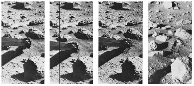
Figure 19. Operation of the surface sampler in obtaining martian soil was closely monitored by one of the Lander cameras because of the precision required in trenching a small area (8 x 10 inches; 20 x 25 centimeters) surrounded by rocks. The exposure of thin crust appeared in unique contrast with surrounding materials and became a prime target for organic analysis in spite of potential hazards. The large rock in the foreground is only 8 inches (20 centimeters) high. At left, the sampler scoop has touched the surface, missing the rock at upper left by a comfortable 6 inches (15 centimeters), and the backhoe had penetrated the surface about 0.5 inch (13 millimeters). The scoop was then pulled back to sample the desired point and (second view) the backhoe furrowed the surface, pulling a piece of thin crust toward the spacecraft. The initial touchdown and retraction sequence was used to avoid a collision between a rock (in the shadow of the arm) and a plate joining the arm and scoop. The rock was cleared by 2 to 3 inches (5 to 7.5 centimeters). The third picture was taken 8 minutes after the scoop touched the surface and shows that the collector head has acquired a quantity of soil. With the surface sampler withdrawn (right), the foot-long (0.3-meter) trench is seen between the rocks. The trench is 3 inches (7.5 centimeters) wide and about 1.5 to 2 inches (3.8 to 5 centimeters) deep. The scoop reached to within 3 inches (7.5 centimeters) of the rock at the far end of the trench. Penetration appears to have left a cavernous opening roofed by the crust and only about one inch (2.5 centimeters) of undisturbed crust separates the deformed surface and the rock.
Terrain
The Martian terrain in the vicinity of the two Viking lander sites is well illustrated in latter part of this article. Of course, these sites represented only a portion of the planet. There are ten or more volcanoes prominent on Mars, with scientific estimates of their age ranging from 100 million years to 1 billion years. See Figs. 20 and 21.
Evidence of erosion, including dry channels resembling riverbeds and tributaries, has led many analysts to conclude that Mars may have had a warmer, more water-rich climate in the past. Photographic evidence from spacecraft indicates that the once-reported “canals” are mostly illusory and that the dark patchy markings once suspected to be vegetation along these canals, varying with the seasons, are in reality simply deposits of wind-blown dust that may be altered from time to time. That alterations can and do occur on Mars is shown by Fig. 22. With the benefit of a few years to assimilate observational data from
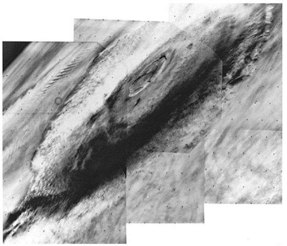
Figure 20. The great Martian volcano Olympus Mons was photographed by the Viking 1 Orbiter on July 31, 1976 from a distance of 8000 kilometers (5000 miles). The 24-kilo-meter-high (15-miles) mountain is seen in mid-morning, wreathed in clouds that extend up the flanks to an altitude of about 19 kilometers (12 miles). The multi-ringed caldera (volcanic crater), some 80 kilometers (50 miles) across, pushes up into the stratosphere and appears cloud-free at this time. The cloud cover is most intense on the far western side of the mountain. A well-defined wave cloud train extends several hundred miles beyond the mountain (upper left). The planet’s limb can be seen at the upper left-hand corner of the view. It also shows extensive stratified hazes. The clouds are thought to be composed mainly of water ice condensed from the atmosphere as it cools while moving up the slopes of the volcano. In the martian afternoon, the clouds develop sufficiently to be seen from earth and it is known that they are a seasonal phenomenon largely limited to spring and summer in the northern hemisphere of the planet. Olympus Mons is about 600 kilometers (375 miles) across at the base and would extend from San Francisco to Los Angeles.
Mariner and the Viking missions, the findings of Pieri et al. (1980) are exceptionally interesting. As explained by Pieri, Mariner 9 orbital reconnaissance mission discovered ubiquitous valley networks in heavily cratered terrain. Branching valley networks throughout the heavily cratered terrain of Mars exhibit no compelling evidence for formation by rainfall-fed erosion (one of the popular hypotheses). Rather, the networks are diffuse and inefficient, with irregular tributary junction angles and large, undissected intervalley areas. The deeply entrenched canyons, with blunt amphitheater terminations, cliff-bench wall topography, lack of evidence of interior erosion of flow, and clear structural control, suggest headward extension by basal sapping.5 The size-frequency distributions of impact craters in these valleys and in the heavily cratered terrain that surrounds them are statistically indistinguishable, suggesting that valley formation has not occurred on Mars for billions of years.
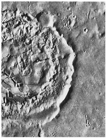
Figure 21. Fine detail in the interior of a martian crater can be seen in this photo taken by Viking 1 of an area near the Viking 2 landing site. The crater (on the left margin of the view) is about 40 kilometers (25 miles) in diameter and shows many features found in lunar craters. The central portion is crossed by numerous cracks. Similar features are seen at the huge lunar impact basin, Orientale. Their origin is unknown, but it has been suggested that the cracks were formed either by consolidation of lava that filled the crater after it formed, or by fallback from the impact process. Alternatively, the cracks may have formed long after the impact event by uplift of the crater floor. Between the cracked terrain and the crater rim is a region of chaotic debris. Beyond the rim there is no evidence of an ejecta blanket (rock material which is blasted from the crater by the shock of the impacting meteorite). The ejecta blanket is presumably overcovered by later deposits.
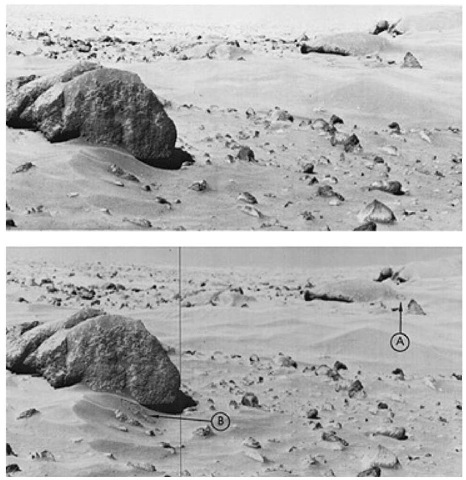
Figure 22. Changes observed by the Viking Landers over a period of time included water-ice snow seen by VL-2 during the winter at Utopia Planitia, and a thin dust layer deposited at both sites during the dust storms of 1977. As shown here, a change occurred by Chryse Planitia over a 4-day period in September 1978. Top photo is the “before” and bottom photo is the “after” view. Change (A) appears as a small circle-like formation on the side of a drift in the lee, or downward, side of”Whale Rock.” This is believed to have been a small-scale landslide of an unstable dust layer which had accumulated behind the rock. Interpretation of this feature would be difficult without an earlier change (B) near ”Big Joe,” a slump. The new slump is observed approximately 25-35 meters (82-115 feet) from the lander craft and just under 1 meter (3.3 feet) across. This slumping was probably initiated by the daily heating and cooling of the surface by solar radiation. More importantly, it is now believed that, based upon the repeated occurrence of such slumping features, a dust layer which overlies the surface may, in fact, be redistributed fairly regularly during periods of high wind activity.
Pieri observes that the branching and coalescent character of the channels provoked immediate comparison to terrestrial riverine networks produced by fluvial6 erosion, a process driven primarily by rainfall. Liquid water, however, cannot now exist at the surface of Mars for more than a few minutes owing to a very low atmospheric pressure and very cold temperatures during most of the year at most latitudes. It has been suggested that these features, if formed by processes similar to those that operate in the formation of earthly river systems, are relics of a more clement epoch. Thus, a major problem in the study of Mars is whether the valley networks could have evolved under current surface conditions, or whether a major shift in Martian climate occurred.
There are certain unifying characteristics of Martian valleys. (Valleys are distinguished from channels by the absence in the former of direct evidence of fluid erosion often found in the latter.) There is no clear evidence (streamlined obstacles, interior channels) of direct fluid erosion in any Martian valley. It is possible that such features are too small to be observed by present instrumentation, although Viking Orbiter images as small as 100 meters (328 feet) can be resolved. Walls of the valleys are typically rugged and clifflike, with some debris accumulation and talus, and the floors are generally flat. Mantling by materials of eolian and volcanic origin is common. Some valleys display cliff-bench interior topography, similar in character and scale to features in the Grand Canyon of the Colorado River. The most striking morphological characteristics, however, are the presence of steep-walled, cuspate terminations at the heads of the smallest tributary valleys. These steep-walled, amphitheater terminations suggest head-ward extension (sapping) by basal undermining and wall collapse, as in the predominant mode of headward extension for many earthly canyons. A variety of Martian terrain is shown in Figs. 23-26.
Martian valley networks lack the dendritic pattern so common to terrestrial streams. The Martian valley patterns show remarkable parallelism and lack of tributary competition for undissected intervalley terrain, and thus appear diffuse compared to terrestrial systems. Viewed from spacecraft, terrestrial drainage systems have a fine, filigreed texture, whereas Martian systems appear coarse.
Pieri has suggested that the valleys were formed on Mars during an ancient epoch by erosional processes involving not rainfall, but the movement of ground-water and its participation as a liquid or a solid in the undermining of less competent strata, causing progressive headward collapse. These processes, combined with modification by impact and eolian (wind) processes, have produced the degraded valleys seen on Mars today.
Even a brief description of the physical features of Mars is not complete without mention of the so-called ”Spokane Flood” concept. As summarized by Baker (1978), in a series of papers published between 1923 and 1932, J.H. Bretz described an enormous plexus of proglacial stream channels that eroded into the loess and basalt of the Columbia Plateau in eastern Washington state. Bretz argued that this region (which he termed the Channeled Scabland) was the product of a cataclysmic flood, which he called the Spokane flood. Considering the nature and vehemence of the opposition to his hypothesis, which at one time was considered highly imaginative, its eventual scientific verification constitutes a fascinating episode in the history of modern science. The discovery of possible catastrophic flood channels on Mars has given new relevance to Bretz’s insights. The connection between Bretz’s proposal and parts of the Martian surface is well developed by Baker.
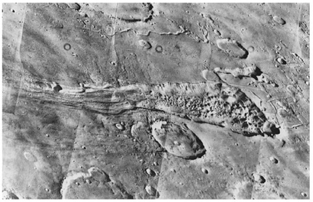
Figure 23. The sinous rille (a relatively long, narrow, trench- or cracklike valley) at the top of this mosaic of 8 photos is believed by some scientists as indicative of flooding of the high plateau in the vicinity of an alternative landing site (known as Capri) for Viking Lander 2. In the foreground is a valley that may have been caused by downfaulting of the martian crust. The hummocks (rounded or conical knolls or mounds of comparatively small elevation) on the valley floor look like chaotic terrain. Some scientists have suggested that the subsidence may be partially caused by melting of the subsurface ice. The large areas of the collapsed terrain show the regional extent of this phenomenon. These views were taken by Viking 1 on July 3, 1976 from a range of 2300 kilometers (1400 miles) and cover an area of about 300 x 300 kilometers (180 x 180 miles). South is toward the top as seen from the spacecraft.
Volcanism. As readily apparent from Viking images, volcanism on Mars was widespread. According to Lucchitta (U.S. Geological Survey), volcanism has formed enormous shields, large composite cones, lobate lava flows, and possibly small cones and pseudocraters. Flood basalts similar to those filling lunar maria may have resurfaced ridged highland plateaus. Large deposits of pyroclastic material may also exist, although their presence is controversial. Dark patches are common on the planet as they are on Earth’s moon, where they have been interpreted as pyroclastic materials. The association of dark patches with pyroclastic volcanism on Mars has been largely overlooked, because most dark patches are inside craters and were obviously accumulated by wind; the possibility was neglected that some Martian dark patches, like lunar ones, may reflect pyroclastic vents. Lucchitta describes dark patches in Valles Marineris that may be such vents and may reflect young mafic volcanism. The evidence for past volcanism on Mars is commonly accepted, but none has been documented in the Valles Marineris equatorial rift system. A recent survey of the troughs in this valley revealed dark patches that are interpreted to be volcanic vents. The configuration and association of these patches with tectonic structures suggest that they are of internal origin; their albedo and color ratios indicate a mafic composition; and their stratigraphic position, crispness of morphologic detail, and low albedo imply that they are young, perhaps even recent. If this volcanism is indeed as young as it seems, Mars has been an active planet throughout most of its history.
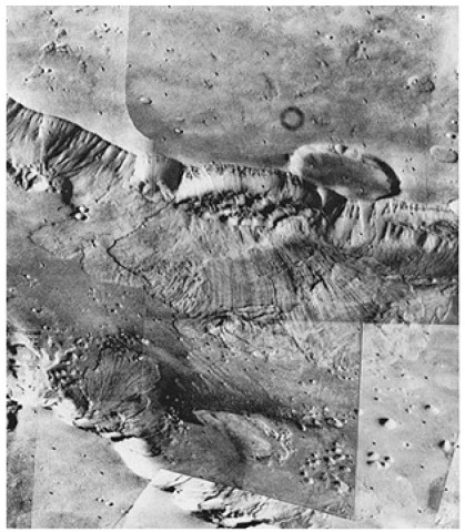
Figure 24. View taken by Viking 1 on July 3,1976 from a range of 2000 kilometers (1240 miles), looking southward across Valles Marineris. This huge equatorial canyon is about 2 kilometers (1.2 mile) deep. The area shown is 70 kilometers (43 miles) by 150 kilometers (94 miles). Aprons of debris on the canyon floor indicate how the canyon may have enlarged itself. The walls appear to collapse at intervals to form huge landslides that flow down and across the canyon floor. Linear striations on the landslide surface show the direction of flow. On the canyon’s far wall in this view, one landslide appears to have ridden over a previous one. Streaks on the canyon floor, aligned parallel to the length of the canyon, probably are evidence of wind action. Layers in the canyon wall indicate that the walls are made up of alternate layers of lava and ash or wind-blown deposits.
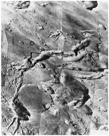
Figure 25. A view obtained by Viking 1 on July 8, 1976 showing what appear to be fault zones in the martian crust in an area two degrees south of the equator. The fault valleys are widened by mass wasting and collapse. Mass wasting is the downslope movement of rocks due to gravity (possibly hastened by seismic shaking if present).
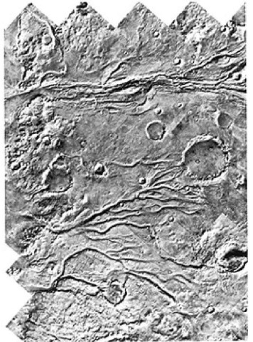
Figure 26. Mosaic of martian surface made by Viking Orbiter 1 over a period between August 4 and 9, 1976. The area is centered at 17 °N, 55 °W, to the west of the Viking 1 Lander site in Chryse Planitia. Just to the west of this area are the plains of Lunae Planum. The terrain shown in this view slopes from west to east with a drop of about 3 kilometers (1.9 mile). The channels are a continuation of those to the west of the VL-1 landing site and, to some scientists, suggest a massive flood of waters from Lunae Planum, across this intervening cratered terrain, and into the general region of the VL-1 landing site. In several cases, it will be noted that channels cut through craters; in others, the craters are clearly later than the assumed flood and are superimposed in the channels.
Case for an Early “Wet” Mars. Certain features of the Martian surface, as observed by the Viking missions, have continued to intrigue and confuse analysts of the data returned from Mars. Included are ancient valleys, channels, and what appear from images to be tributary systems. What appear to be numerous extinct volcanoes and meteoritic craters over which more recent geologic features have been superposed are found in the images. For many of these features, the presence of water in relatively large quantities on the planet during its earlier phases offers the most tempting solution. Many scenarios have been developed. For example, some scientists at the Jet Propulsion Laboratory (Pasadena, California) suggested, at a symposium of the Lunar and Planetary Institute (see reference listed), that lakes, or a shallow sea or ocean, may have encompassed as much as 10 to 15% of the Martian surface and of a generous portion of the northern plains from 2 to 3 billion years ago. Timothy Parker (JPL) estimates that the water would have been about 100 meters deep (or less), making the sea’s volume equivalent to a layer of about 10 meters deep covering the globe. This volume of water in a hypothetical sea would equal all the water that some geochemists have allowed for the entire planet. But, all do not agree. Michael Carr (U.S. Geological Survey) reported that the latest estimates of the amount of water hidden beneath the surface may be several times greater. Some investigators believe that the surface of Mars, something comparable to Earth’s moon, is made up of rubble and porous soil well capable of storing ice, water, or brine. Stephen Clifford (Lunar and Planetary Science Institute) estimates that this megarego-lith has the capacity to hold water equivalent to a global layer 200 to 500 meters deep. The main remaining question, of course, is how much of that capacity is actually filled? Certainly, the unanswered question of the amount of water that was and still may be trapped on the planet is central to preparing a satisfactory model of the planet.
Age Determination. Mars has been mapped extensively by Mariner 9 and later by the Viking missions. One major goal in planetary science is to determine the chronology of development of the surfaces of the terrestrial planets, particularly Mars. As indicated in an excellent paper by Neukum and Wise (1976), cratering links to lunar time suggest that Mars died long ago. Fortunately, for the purpose of age determination from photographs, Mars is impact-cratered. Differences in impact crater frequencies at different sites reflect differences in age. Two attempts have been made to determine absolute age for Mars from its measured crater frequencies, based on extrapolations from the cratering chronology of the lunar surface (Hartman, 1973; Soderblom et al., 1974). Unfortunately, a straightforward comparison of martian and lunar crater frequencies does not necessarily yield true ages; relative impact rates and the time dependence of the martian cratering rate are not known; and it is not certain whether the same meteoroid population bombarded both planets.
At Mariner 9 resolution, the impact crater production size-frequency distribution of Mars is generally similar to that of the moon for crater diameters in the range 0.8 to 50 kilometers (0.5 to 31 miles), and it appears to have been relatively stable through time. The lunar and Martian crater curves can be brought into near coincidence by a diameter shift appropriate to reasonable impact velocity differences between bodies hitting Mars and the Moon. This indicates that a common population of bodies impacted both planets and suggests the same or a very similar time dependence of impact flux. Constraints on relative lunar and Martian fluxes can be obtained by comparing crater frequency data for the lunar and martian highlands and for Mars’ satellite Phobos.
These cratering constraints, as pointed out by Neukum and Wise, provide the basis for a tentative Martian time scale derived from lunar data. Previous time scales have painted a picture of a disorderly planetary evolution of Mars, punctuated by a strange pulse of Tharsis Ridge tectonic and volcanic activity late in geological history. The new scale suggests a much more orderly evolution with Mars, like the Moon, winding down most of its major planetary tectonic and volcanic disturbances in the first 1.5 billion years of its history. By 2.5 billion years ago the volcanic-tectonic era on Mars had ended.
Other Physical Characteristics of Mars
Doppler radio-tracking data have provided detailed measurements for a Martian gravity map extending from 30 °Sto65 °N latitude and through 360° of longitude. The feature resolution is approximately 500 kilometers (310 miles), revealing a huge anomaly associated with Olympus Mons, a mascon in Insidis Panitia, and other anomalies correlated with volcanic structures. Olympus Mons has been modeled as a disk of 600-kilometer (372-mile) surface area, having a mass of 9.7 x 10²¹ grams. The very large Olympus Mons anomaly should have a very significant impact on geophysical modeling of the planet. Similarly, the Elysium anomaly and the Insidis mascon should place constraints on the internal structure. Gravity in the southern hemisphere remains poorly resolved.
A three-axis short-period seismometer was delivered to the surface of Mars by Viking Lander 2 on September 3, 1976. Noise background correlated well with wind gusts. Data returned to earth indicated that Mars is a very quiet body.
The amounts of magnetic particles held on the reference test chart and backhoe magnets on Viking Landers 1 and 2 were comparable, indicating the presence of an estimated 3-7% (weight) of relatively pure, strongly magnetic particles in the soil. It is argued that the results indicate the presence, now or originally, of magnetite, which may be titaniferous.
Dust Devils on Mars. Several scientists, after studying Viking data, have reported the existence of dust devils (columnar, cone-shaped, and funnel-shaped clouds rising 1 to 6 km above the surface) on Mars. Dust devils result from atmospheric conditions that occur close to the ground and are, therefore, sensitive to surface topography. Dust devils on Mars may be responsible for the initiation of large dust storms on the planet and for increasing the general atmospheric dust content.
Dust devils, as observed by Thomas and Gierasch (Cornell University), have meteorological as well as geological significance. Fluid motions in an atmospheric boundary layer can be driven either by stresses due to the mean wind (forced convection) or by buoyancy due to heating of the gas adjacent to the surface (free convection). Dust devils are an example ofthe latter. On Earth, large-scale eolian transport is generally due to forced convection. The investigators report that moderate to high winds characterize forced convection, and on Mars, where the atmospheric density is only about 1% of that on Earth, it is estimated that winds must exceed about 25 to 40 meters sec ~1 to initiate soil movement.
One of the major geologic processes on Mars is the entrainment and transportation of dust by winds. Observations on the genesis and development of local and global dust storms on Mars are sparse.
Tornadolike Tracks on Mars. Some images from the Viking Orbiter reveal well defined, dark filamentary lineations in numerous locations on the Martian surface. On Earth, tornadic-intensity vortices commonly leave distinctive tracks whose appearance is similar to that of the Martian lineations. A high-resolution imaging system, as proposed for the Mars Observer mission, could resolve these ground tracks. The filamentary lineations, as reported by Grant and Schultz (Brown University) are from 2 km to at least 75 km long and less than 1km wide. Most are straight to curvilinear, and some have obvious nontopographically initiated gaps in their path. The visible occurrence of the lineations appears to be seasonal. In the southern hemisphere, they were visible (from Mariner 9) only from midsummer into early fall. After formation, they were rapidly modified and were no longer visible by midfall. In the northern hemisphere, lineations appear from early to midsummer. By late summer, these lineations also become smeared and faint. Natural Laser Phenomenon Noted on Mars. Based upon observations made with the Goddard infrared heterodyne spectrometer during the period of January to April 1980, when the planet was near opposition, astronomers M.J. Mumma and colleagues (NASA-Goddard Space Flight Center) and D. Zipoy (University of Maryland) noted natural gain amplification in the mesosphere of Mars, probably representing the first definite identification of a natural infrared laser. Natural microwave amplifiers (masers) are abundant in interstellar clouds and some circumstellar shells, primarily among the rotational level populations of certain molecules, such as OH, SiO, and H2O, but no optical lasers in nature had previously been observed. As reported by Mumma et al., many examples of natural nonthermal optical emission have been found, such as the infrared and ultraviolet auroras or the day glows of Earth, Jupiter, Mars, and Venus. Details are reported in the reference listed.
Pole Wandering and Crustal Shifts on Mars
Careful study of Viking images has revealed a number of features of the planet that are very difficult to explain. For example, regions at the planet’s equator seem once to have been near a pole. As observed by Schultz (see reference), in certain areas of the surface, erosion appears to have occurred at a very low rate (perhaps less than a millimeter in a million years). But, in other areas, at the same latitude, there are regions that have been heavily stripped and etched by the wind. Also, very old networks of narrow valleys, once cut into the surface by flowing water, suggest a warm climate, although such networks are seen within 10 degrees of the southern polar ice cap. While many details remain to be worked out, Schultz suggests that one hypothesis may explain all or most of the contradictions: the orientation in space of the Martian crust has not always remained the same throughout geologic time, but rather, it has shifted with respect to the planet’s axis of spin. This would require that the spin axis, which intersects the planet’s surface at the north and south poles, would appear to have wandered over the planet’s crust. This would indicate that certain regions of the crust, presently far from the poles, may have been at some time in the past within the polar regions. In introducing a detailed paper on this topic, Schultz observes that if Mars had undergone polar wandering, then martian geology may have to be viewed in the context both of a dynamically changing planet like the Earth and of a stable, rigid body like the Earth’s moon. In this sense, the Martian equivalent of plate tectonics might simply be the movement of the entire litho-sphere, the solid outer portion of the planet, as one plate.
Martian Satellites
Mars has two satellites, Phobos, the inner and larger of the two moons, and Deimos. These satellites were visited during the Viking missions. Phobos. This satellite revolves around Mars in an orbit of about 9330 kilometers (5800 miles) from the center of Mars (some 5950 kilometers; 3700 miles above the planet’s surface). The diameter was stated in the introductory section of this entry. Its orbital period is 7 hours, 40 minutes. Because its orbital period is in the same direction as, but is less than, that of Mars, it rises in the west and sets in the east as seen from Mars. Phobos is heavily cratered and dark in color, of a material resembling carbonaceous chondrite meteorites. A system of grooves, possibly marking fractures, is associated with the largest crater, Stickner, which is about 10 kilometers (6.2 miles) across.
Viking Orbiter 1 flew within 480 kilometers (300 miles) of Phobos to obtain the view given in Fig. 27. A view much closer to the satellite is given in Fig. 28. A considerably later view, made in 1978, is given in Fig. 29.
Deimos. This satellite revolves around Mars in an orbit about 23,000 kilometers (14,260 miles) from the center of Mars. Five close flybys, within 1000 kilometers (620 miles) of Deimos, were made in October 1977. The closest encounter was on October 5, 1977 when the spacecraft passed within 50 kilometers (30 miles) of the moon’s surface. Images indicated that the surface of Diemos differs considerably from that of Phobos. Deimos has many craters, but appears smoother than Phobos. See Fig. 30. With reference to the peculiar blocks observed on Deimos, which are visible in the illustration, Duxbury and Veverka (1978) suggest: ”If the bright patches and blocks represent ejecta, then it is puzzling why apparently so much of it was retained by such a small satellite and
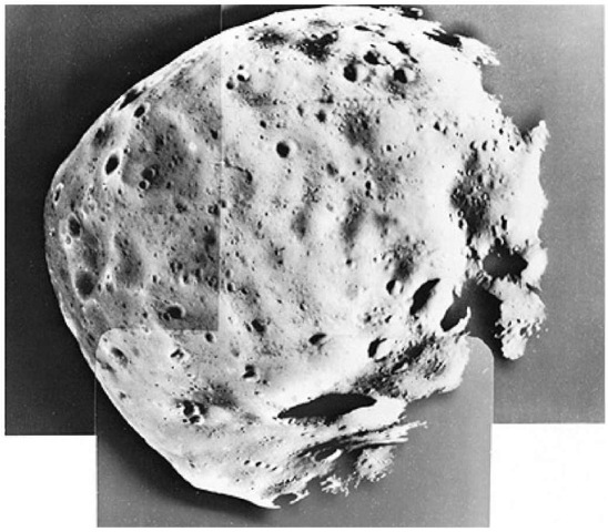
Figure 27. View of Phobos taken by Viking Orbiter 1 from a distance of 480 kilometers (300 miles). This mosaic of 3 pictures was made in February 1977. As seen here, Phobos is about 75% illuminated and is about 21 kilometers (13 miles) across and 19 kilometers (11.8 miles) from top to bottom. North is at top. The south pole is within the large crater (Hall) with a diameter of 5 kilometers (3.1 miles) and will be noted at bottom center where the pictures overlap. Some features as small 20 meters (65 feet) across can be seen. Remarkable features include striations, crater chains, a linear ridge, and small positive features which appear to be resting on the surface. A long linear ridge is seen starting near the south pole and extending to the upper right. A very sharp wall at the intersection of two craters (about 1 kilometer; 0.6 mile across) is seen along this ridge at right. A series of craters runs horizontally in the picture which is parallel to the orbit plane of Phobos. These crater chains are commonly associated with secondary cratering by ejecta from larger impacts. A surprising discovery has been made of what apparently resembles hummocks or small positive features. These features, primarily seen near the terminator (right), are about 50 meters (165 feet) in size and may be surface debris from previous impacts.
why the process seems to be so much more efficient on Deimos than on Phobos. It is conceivable that the very close proximity of Phobos to Mars makes it easier for impact ejecta to escape from the inner satellite, but the mechanics of such a preferential process remain to be worked out.”
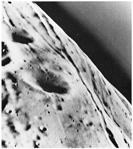
Figure 28. Viking Orbiter 1 took this close-up picture of Phobos from a range of 120 kilometers (75 miles) on February 20,1977. This is the closest range at which a spacecraft has photographed the tiny satellite. At that range, Phobos is too large to be captured in a single frame. This picture covers an area 3 x 3.5 kilometers (1.86 x 2.17 miles). A single picture element is about 3 meters (7.5 feet) across. However, the high relative speed of Orbiter 1 and Phobos caused some image smear so that the smallest surface feature identifiable is between 10 and 15 meters (32 and 49 feet). The picture shows a region in the northern hemisphere of Phobos that has striations and is heavily cratered. The striations, which appear to be grooves rather than crater chains, are about 100 to 200 meters (328 to 656 feet) wide and tens of kilometers long. Craters range in size from 10 meters (32 feet) to 1.2 kilometers (0.75 mile) in diameter. The surface of Phobos appears similar to the highland regions of the earth’s moon, which also is heavily cratered and an ancient terrain. The dark region above the limb of Phobos is an artifact of processing and does not indicate an atmosphere.
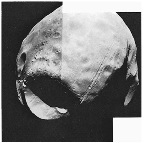
Figure 29. This view of Phobos was made by Viking Orbiter 1 on October 19, 1978 at a range of 612 kilometers (379 miles) during the spacecraft’s 854th revolution of Mars. This view was made just before Phobos entered the shadow of the planet. The photomosaic shows the front side of Phobos which always faces Mars—from about 10° below the equator with north at the top. Stickney, the largest crater on Phobos (10 kilometers; 6.2 miles across) is at the left near the morning terminator. Linear grooves coming from and passing through Stickney appear to be fractures in the surface caused by the impact which formed the crater. Two earlier new encounters with Phobos brought Viking Orbiter 1 within close range of the satellite, but had not provided scientists with good opportunities to observe Stickney as well. This view provides new high-resolution coverage of the front side of Phobos (approximately 19 x 22 kilometers; 11.8 x 13.6 miles as seen here) as well as the highest resolution yet achieved of the western wall of Stickney. Kepler Ridge is casting a shadow in the southern hemisphere which partially covers the large crater (Hall) at the bottom.
Additional Post-Viking Mission Studies and Hypotheses
Further studies of the Viking information and observations made from Earth in recent years have posed interesting new questions pertaining to Mars.
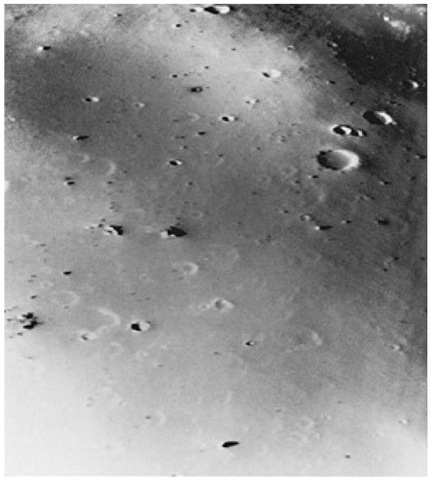
Figure 30. View of the Martian moon Deimos taken on October 15, 1977 when Viking Orbiter 2 passed within 50 kilometers (30 miles) of the satellite. The picture covers an area 1.2 x 1.5 kilometers (0.74 x 0.93 mile) and shows features as small as 3 meters (10 feet). Deimos is saturated with craters, but a layer of dust appears to cover craters smaller than 50 meters (165 feet) in diameter, making Deimos look smoother than the other Martian moon, Phobos. Boulders as large as houses (10 to 30 meters; 33 to 100 feet) across are strewn about the face. It is suggested that these objects may be blocks ejected from nearby craters. The spacecraft would have been clearly visible to an observer standing on the surface of Deimos.
Radar Images of Mars. In late 1991, D.O. Muhleman and a team of researchers (California Institute of Technology) conducted aperture synthesis mapping of Mars by using the Very Large Array (VLA) in New Mexico as the imaging instrument to detect continuous wave signals transmitted at 9.5 GHz (3.5 cm) from the Jet Propulsion Laboratory (JPL) 70-meter antenna in
Goldstone, California.Summary of the project: ”The surface of Mars was illuminated with continuous wave radiation. The reflected energy was mapped in individual 12-minute snapshots with the VLA in its largest configuration; fringe spacings as small as 67 km were obtained. The images reveal near-surface features, including a region in the Tharsis volcano area, over 2000 km in east-west extent, that displayed no echo to the very low level of the radar system noise. This feature (called Stealth)is interpreted as a deposit of dust or ash with a density less than about 0.5 grams/ cubic centimeter and free rocks larger than 1 cm across. The deposit is envisioned to be several meters thick and may be much deeper. The strongest reflecting geological feature was the south polar ice cap, which was reduced in size to the residual south polar ice cap at the season of observation. The cap image is interpreted as arising from nearly pure carbon dioxide or water ice with a small amount of Martian dust (less than 2 percent by volume) and a depth greater than 2 to 5 meters. Only one anomalous reflecting feature was identified outside of the Tharsis region, although the Elysium region was poorly sampled in this experiment and the north pole was not visible from Earth.” More detail is given in reference listed.
Radar Detection of Phobos. During the exceptionally close approach of Mars to Earth in the autumn of 1988, the Goldstone 70-meter antenna was used as a radar telescope to observe Phobos. A total of 117 transmit/receive cycles were completed. Radar echoes from the Martian satellite provided information about the object’s surface properties at scales near the 3.5-cm observing wavelength. In summary, ”Phobos’s surface apparently resembles those of many (if not most) large, C-class asteroids in terms of bulk density, small-scale roughness, and large-scale topographic character, but differs from the surfaces of the moon and at least some small, Earth-approaching objects. Additional 3.5-cm and 13-cm radar observations of asteroids, comets, and the martian satellites can clarify these relations.”
Simulating the Surface of Phobos. Researchers (University of Arizona, Lunar and Planetary Laboratory) in recent years have been attempting to simulate how certain distinct features of Phobos may have been formed and as imaged by the Viking orbiters. Lines (rows) of comparatively small craters resemble a beaded chain unlike other features found in the planetary system thus far. An initial hypothesis described the features as being formed out of secondary ejecta—that is, debris resulting in a crater-causing impact. In attempting to duplicate the unusual feature in the laboratory, the researchers have developed an apparatus consisting of a pair of narrow, rigid glass plates and a variety of materials, including expanded vermiculite, silica sand, and small glass spheres. Intense interest in unusual surface conditions is not new in connection with planetary space explorations. Ponder, for example, the variety of scientific opinions that were expressed prior to touchdown of Surveyor, the first unmanned spacecraft to land on the Moon. From their work to date, the researchers have suggested that Phobos may be covered with a regolith some 300 meters thick! A Peopled Mission to Mars. Although, in the early 1990s it was delayed for want of funding and other political considerations (due in part to some lack of interest on the part of the public) an Apollo-type mission to Mars is in the advanced planning phase. Conservative scientists have suggested, however, that another Viking-type venture may be the safest and most sensible step prior to putting human lives at risk. Probably the most intense interest in a fully blown venture stemmed from Russian scientists, who have been preparing for a “Soviet” Phobos mission. A major concern has been and continues to be that of prolonged crew interest and mental and physical reactions to a sojourn in space that would require a currently calculated minimum of 15 months from launch to return on Earth. This has been referred to as the “Sprint” mission. For example, if it were assumed that the mission would leave Earth on 19 November 2004, it would reach at Mars on 30 July 2005 and depart Mars on 20 August 2005, returning to Earth on 2 February 2006. Time of stay on Mars would be less than 1 month and fuel costs would be at a maximum. A much longer (31 months) mission could be much more fuel efficient, and the stay on Mars could be considerably longer.
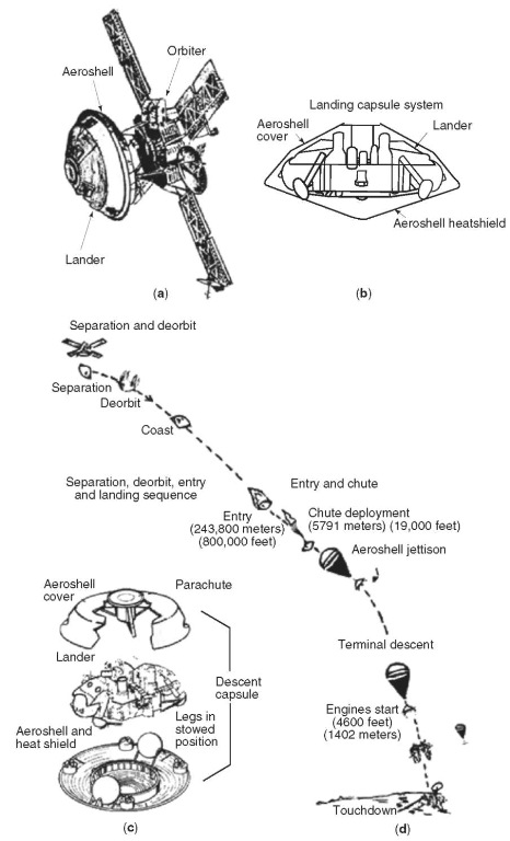
Figure 31. Principal subsystems of the Viking spacecraft: (a) Orbiter and Lander linked together as they travel through space; (b) landing capsule system; (c) aeroshell cover, parachute, and descent capsule; and (d) separation, deorbit, entry, and landing sequence.
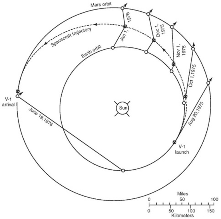
Figure 32. Trajectory followed by Viking 1. Dates given show relationship of earth, spacecraft. Mars, and the sun at specific times.
The Viking Missions to Mars
Two identical spacecraft, Viking 1 and Viking 2, were launched in 1975 to explore Mars. In actuality, there were four spacecraft in all—a Viking 1 orbiter and lander and a Viking 2 orbiter and lander. Each orbiter and lander traveled together as one unit to rendezvous with Mars. The principal subsystems of the Viking spacecraft and separation, deorbit, entry, and landing sequences are shown in Fig. 31. The principal Viking events occurred as follows:
Viking 1 Viking 2
Date of launch August 20, 1975 September 10, 1975
Placed in elliptical orbit around Mars June 6, 1976 August 7, 1976
Touchdown of Lander July 20, 1976 September 3, 1976
Viking 1 traveled nearly 676 million kilometers (420 million miles) and Viking 2 nearly 713 million kilometers (443 million miles) in their heliocentric Mars intercept trajectories prior to their respective insertions into elliptical orbits around the planet. See Figs. 32 and 33. Timing of the Viking missions was planned to achieve the trajectory situation shown. The Mars orbit insertion maneuvers for the Vikings require significant engine burns—in the case of Viking 1, for example, 38 minutes, consuming 2330 pounds (1057 kilograms) of propellant. Once in the Martian vicinity, radio signals required 22 minutes in either direction between earth and Mars, thus a total of 44 minutes to execute a command and receive confirmation of that command. The general plan successfully followed in the Viking program involved orbiting the spacecraft in their respective orbits around Mars for several days, not only to commence imaging of the planet and certain scientific experiments, but to reconfirm earlier decisions concerning the best landing sites to finally elect for the two landers. Then, much as the Surveyor soft lunar landing craft had been placed on the Earth’s Moon several years before, the landers were released from the aeroshells on the orbiting spacecraft, using parachute deployment at an elevation above the Martian surface of about 19,400 feet (5,913 meters) and the firing of terminal-descent engines at about 4,600 feet (1,402 meters) above the planet’s surface. Both landers touched down successfully. Later, adjustments were made to the Viking or-biters to provide better imaging of additional areas of the planet. Transmissions from the orbiters and the landers extending over an extensive period and information from one of the spacecraft was still being received during the early 1980s.
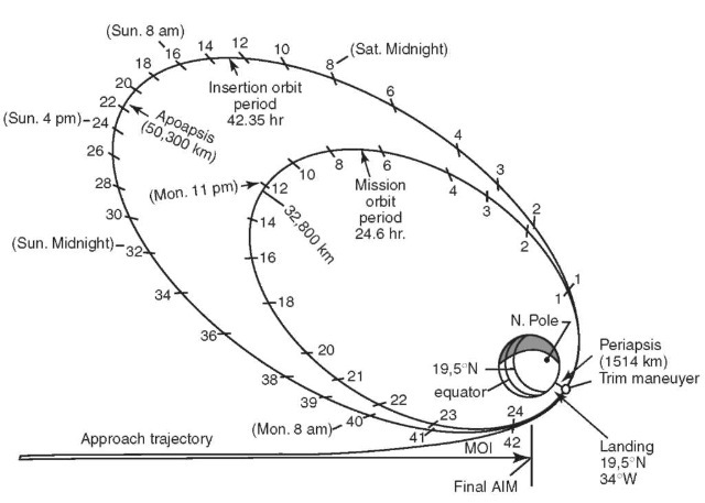
Figure 33. Orbit geometry for the insertion and mission orbits. Viking 1 completed only one revolution on the insertion orbit before the trim maneuver placed it on the mission orbit. The tick marks indicate spacecraft flight hours with periapsis as the zero point. (Periapsis — the orbital point nearest the focus of attraction; apoapsis — the farthest point.) Additional information at selected points along the insertion orbit indicate where the spacecraft was that day relative to Earth Pacific Daylight Time. A complete revolution of Mars on the mission orbit required 24.6 hours, the length of a martian day. The orbit was synchronized with the landing site in that the spacecraft passed over the site once each day near periapsis, allowing maximum resolution orbital photography of that region for site certification and surface-data (after landing) correlation.
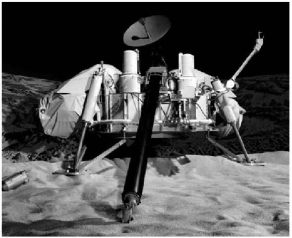
Figure 34. One of the Viking Landers (test model) in a simulated Martian setting. This spacecraft was set up in the auditorium at NASA’s Jet Propulsion Laboratory to thoroughly familiarize the many scientists on the project with the detailed operation of the spacecraft’s mechanical sampling system and other scientific experiments aboard.
The Viking Landers
To assist in familiarizing many scientists at the control center in the detailed operation of the complex Viking landers, a test lander was installed in the auditorium at NASA’s Jet Propulsion Laboratory in Pasadena, California.
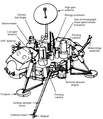
Figure 35. Principal features of the Viking Lander.
The first photograph ever taken on the surface of Mars is shown in Fig. 38. This picture was taken just minutes after Viking Lander 1 touched down successfully at Chryse Planitia. The center of the image is about 1.4 meters (5 feet) from camera No. 2 of the spacecraft. A similar view of the martian surface taken by Viking Lander 2 shortly after touchdown at Utopia Planitia is shown in Fig. 39.
The first photograph of the Martian landscape (Chryse Planitia site) is shown in Fig. 40. In real color, this view is predominantly reddish brown. A diagram of the Viking 1 Lander and showing field of view with reference to equipment components is given in Fig. 41. Another striking view of the Martian landscape of Chryse Planitia is shown Fig. 42. The Martian landscape at the Utopia Planitia site is shown in Fig. 43.
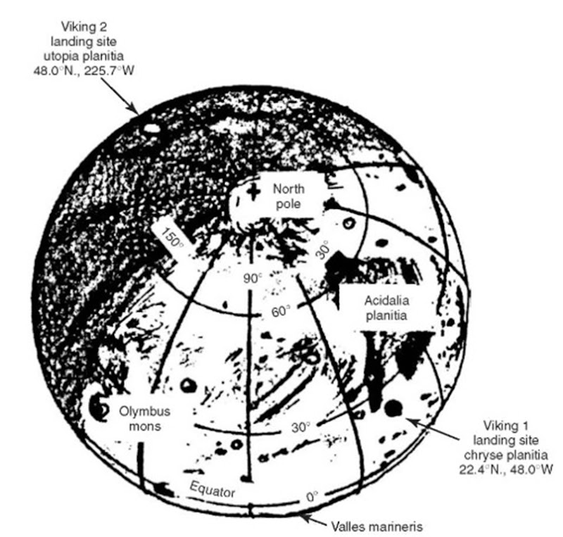
Figure 36. Locations of the two Viking landing sites on Mars.
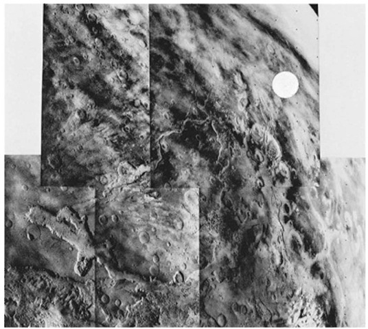
Figure 37. View from Viking 1 Orbiter showing two candidate landing sites. White circle indicates prime site in Chryse where Viking Lander 1 touched down a few days later. In this group of five adjoining photos taken from about 32,000 kilometers (20,000 miles) through a violet filter, Chryse is shown lying at the mouth of the channels, which proceed southward on the planet. An alternative site lies on a plateau adjacent one of the canyons in the lower (foreground) part of the picture. A bit of the planet’s limb can be seen in the upper right-hand corner. Near the lower right-hand corner is a white cloud, believed to be ice crystals. From a comparison with pictures taken three minutes apart, the cloud was found to be moving about 97 kilometers (60 miles) per hour toward the upper left of view. Overall, the picture spans about 40° in longitude and 35° in latitude. The prominent feature in the lower left frame is Grangis Chasma, an arm of the great equatorial rift. North in these views is toward upper-right-hand corner.
Viking Scientific Experiments
Thirteen scientific investigations yielded information about the atmosphere and surface of Mars. Two orbiters and landers operating for several months photographed the surface extensively from 1500 kilometers (930 miles) and directly on the surface. Measurements were made of the atmospheric composition, the surface, elemental abundance, the atmospheric water vapor, temperature of the surface, and meteorological conditions: direct tests were made for organic material and living organisms.7
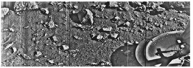
Figure 38. First photograph ever taken on surface of Mars, obtained by Viking 1 Lander just a few minutes after its successful touchdown on Chryse Planitia. The center of the image is about 1.4 meters (5 feet) from camera #2 of the spacecraft. Both rocks and finely granulated material—sand and dust—are observed. Many of the small foreground rocks are flat with angular facets. Several larger rocks exhibit irregular surfaces with pits and the large rock at the top left shows intersecting linear cracks. Extending from that rock toward the camera is a vertical linear dark band, which may be due to a one-minute partial obscuration of the landscape due to clouds or dust intervening between the sun and the surface. Associated with several of the rocks are apparent signs of wind transport of granular material. The large rock in the center is about 10 centimeters (4 inches) across and shows three rough facets. To its lower right is a rock near a smooth portion of the Martian surface, probably composed of very fine-grained material. It is possible that the rock was moved during the Viking 1 descent maneuvers, revealing the finer-grained basement substratum; or that the fine-grained material had accumulated adjacent to the rock. There are numerous other furrows and depressions and places with fine-grained material elsewhere in the view. At right is a portion of footpad #2. Small quantities offine-grained sand and dust are seen at the center of the footpad near the strut and were deposited at landing. The shadow to the left of the foodpad clearly exhibits detail, due to scattering of light either from the Martain atmosphere or from the spacecraft, observable because the Martian sky scatters light into shadowed areas.
Inorganic Chemistry. An X-ray fluorescence spectrometer was used to determine the elemental composition of samples at each lander site. Both sites yielded analyses of the fine-particle materials that are strikingly similar. Silica and iron in large amounts and magnesium, aluminum, calcium, and sulfur in significant amounts. More detail pertaining to the inorganic aspects of the martian surface and rock materials are given in the entry on Mars. The trenching and sampling equipment on the Lander spacecraft are shown in the foreground of Fig. 20. Plan views of the sampling apparatus and procedures followed the Viking Landers are given in Figs. 44 and 45.
Molecular Analysis. Two samples from each lander site were analyzed for organic material with successive use of volatilization, pyrolysis, and detection by gas chromatography-mass spectrometry (GCMS). The sensitivity of the method is of the order of parts per billion. No organic compounds were detected at that level. The instrument was not designed to detect life—neither the quality or sensitivity permitted detecting biomass directly. The absence of organics in the sample was somewhat surprising considering the likelihood of carbonaceous chondrites reaching the Martian surface, or the possibility of de novo synthesis. Explanations involving dilution in the regolith and destruction by ultraviolet light or oxidation are all plausible. The GCMS was also used to measure the Martian atmosphere. It was ideally suited to measure isotopic ratios. Based upon measurements of nitrogen, argon, xenon, and krypton and their isotopic abundances, it is believed unlikely that a history of Mars outgassing will emerge.

Figure 39. First photograph of Martian surface taken by Viking Lander 2 at the Utopia Planitia site. The scene reveals a wide variety of rocks littering a surface of fine-grained deposits. Boulders in the 10-20 centimeter (4—8 inch) size range—somewhat vesicular (holes) and some apparently fluted by wind—are common. Many of the pebbles have tubular or platy shapes, suggesting that they may be derived from layered strata. The fluted boulder just above the Lander’s footpad displays a dust-covered or scraped surface, suggesting it was overturned or altered by the foot at touchdown. Brightness variations at the beginning of the picture scan (left edge) probably are due to dust settling after landing. A substantial amount of fine-grained material kicked up by the descent engines has accumulated in the concave interior of the footpad. Center of the image is about 1.4 meters (5 feet) from the camera. Field of view extends 70° from left to right and 20° from top to bottom. This second landing location is in the northern latitudes about 7500 kilometers (4600 miles) northeast of the Viking 1 Lander site, where touchdown occurred 45 days earlier.

Figure 40. First panoramic view of Martian surface taking by Viking 1 Lander. The out-of-focus spacecraft component toward left center is the housing for the Viking sample arm, which is not yet deployed. Parallel lines faintly seen in the sky are an artifact and are not real features. However, the change of brightness from horizon toward zenith and toward the right (west) is accurately reflected in this picture, which was taken in the late Martian afternoon. At the horizon to the left is a plateaulike prominence much brighter than the foreground material between the rocks. The horizon features are approximately three kilometers (1.8 miles) away. At left is a collection of fine-grained material reminiscent of sand dunes. The dark sinous markings in the left foreground are of unknown origin. Some unidentified shapes can be perceived on the hilly eminence at the horizon toward left center of view. The horizontal cloud stratum can be made out halfway from the horizon to the top of the picture. At the center is seen the low-grain antenna for receipt of commands from earth. The projections on or near the horizon may represent the rims of distant impact craters. In the right foreground are color charts for Lander camera calibration, a mirror for the Viking magnetic properties experiment and pan of a grid on the top of the Lander body. At upper right is the high-gain dish antenna for direct communication between the landed spacecraft and earth. Toward the right edge is an array of smooth, finegrained material which shows some hint of ripple structure and may be the beginning of a large dune field off to the right of the view, which joins with dunes seen at the top left in this 300° panoramic view. Some of the rocks appear to be undercut on one side and partially buried by drifting sand on the other.

Figure 41. This diagram illustrates a full 360° image from camera #2 on the Viking Lander spacecraft. The outlined image areas represent the Viking 1 Lander’s first two pictures (Figs. 10 and 12). This type of diagram helped analysts at the mission control center to identify photo orientation in terms of pans of the Lander spacecraft components when they appeared in various views.
Biology Experiments. Three experiments were conducted to test directly for life on Mars. The tests revealed a surprisingly chemically active surface—very likely oxidizing—but no evidence concerning the existence of life on the planet.

Figure 42. Martian landscape as viewed by Viking 1 Lander, showing a dune field with features remarkably similar to many seen in the deserts on earth. The early morning lighting (7:30 A.M. local Mars time) reveals subtle details and shading. The picture covers 100 ° , looking northeast at left and southeast at right. Viking scientists observed that this area is reminiscent of regions in Mexico, California, and Arizona (Kelso, Death Valley, Yuma). The sharp dune crests indicate the most recent wind storms capable of moving sand over the dunes in the general direction from upper left to lower right. Small deposits downwind of rocks also indicate this wind direction. Large boulder at left is about 8 meters (25 feet) from the spacecraft and measures about 1 x 3 meters (3 x 10 feet). The meteorology boom, which supports the spacecraft’s miniature weather station, cuts through the center of the picture. The sun rose two hours earlier and is about 30° above the horizon near the center of the view. In real color, the landscape is predominantly reddish brown.
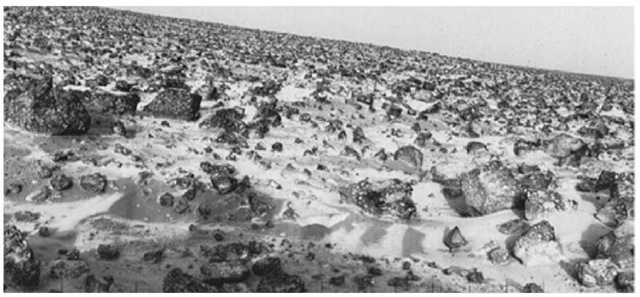
Figure 43. High-resolution photo of the Martian surface taken by Viking Lander 2 at the Utopia Planitia landing site. View was made on May 18, 1979 and relayed to earth by Obiter 1 on June 7. The ”rolling hill” Marscape is an artifact of the Lander’s 8-degree tilt; the horizon is generally flat. There is some relief of the flat terrain, however, at lower scales locally and at greater scales on the horizon. In stereo, a few gullies and depressions take on considerable depth and dimension. A thin coating of water ice on the rocks and soil is visible. The time the frost appeared corresponded almost exactly with the build-up of frost one Martian year (23 earth months) earlier when a similar view had been taken. The frost remained on the surface for about one hundred days. Some scientists believe dust panicles in the atmosphere may pick up bits of solid water. But carbon dioxide present in the Martian atmosphere also may freeze and adhere to particles, becoming sufficiently heavy to settle. Warmed by the sun, the surface evaporates the carbon dioxide and returns it to the atmosphere, leaving behind water and dust. The ice seen in this picture, like that which formed during the earlier martian year, is extremely thin, perhaps no more than 1/1000 inch (0.03 millimeter) thick.
The biological experiments were conducted with fully programmed and automated miniature laboratory equipment installed in each Viking lander. In the pyrolytic release (PR) experiment, Martian soil was placed in a chamber, after which carbon dioxide and carbon monoxide were added. These compounds were traceable because of the addition of radioactive carbon-14. The soil was incubated beneath a lamp that simulated Martian sunlight, but with no ultraviolet radiation present, as is the actual case on the planet today. If microorganisms were present, they would take up the radioactive gases. The chamber was heated to pyrolyze (decompose) any microbes present in the organic gases. The gases then were forced into an organic vapor trap, allowing other gases to pass to a radiation detector for ”first count.” With additional heating, the ”organic vapors” were released and, if radioactive, they would indicate that living organisms were present. Results were negative.
In the labeled release (LR) experiment radioactive nutrient was added to a soil sample. Microorganisms present would digest the nutrient and release radioactive carbon dioxide. The soil is permitted to ”incubate” for a period of a week or more, with further additions of nutrient. Results were negative.
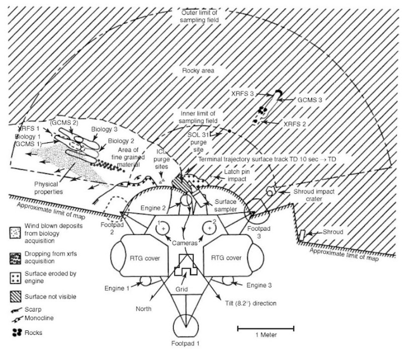
Figure 44. Plan view of Viking Lander 1, showing the spacecraft and its orientation, location of sample sites, locations of selected rocks for analytical experiments. 1 Sol — 1 complete Martian day and night; XRFS — x-ray fluorescence spectrometer; GCMS — gas chromatograph-mass spectrometer; ICL — initial rock to be investigated.
In the gas exchange (GEX) experiment, scientists were looking for changes that Martian microbes might cause in gas levels over a long period. Soil was placed in a chamber, which was sealed to prevent gas leakage. Just sufficient nutrient flows admixed with water vapor would awaken spores or seeds, changing the gas level in the experiment. The results were negative. Considerable production of oxygen was noted from the GEX experiment, more or less explained as unusual Martian exotic chemistry.
No plausible ties with living organisms were established. There continues to be some speculation that the chemical oxidative qualities of Martian soil may support microorganisms of a sort which earth-bound scientists have not described even on a sound theoretical basis.
Meteorology. A meteorological weather station to measure changes in pressure, temperature, wind speed and direction operated well on both landers. Generally, the weather at both sites was repetitive, with a daily temperature variation of between 190 and 240 K, the peak usually occurring in mid-afternoon Martian time. The pressure at each site was in the range of 7 to 8 millibars. Daily pressure variations were about 0.3 millibar.
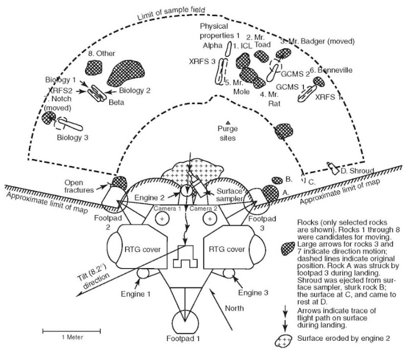
Figure 45. Plan view of Viking Lander 2, similar to that of Fig. 29.
Seismology. The seismometer on Viking Lander 1 failed to be uncaged, but the Viking 2 functioned normally. Little or no quake activity was detected.
Atmospheric Water Detector. An infrared spectrometer operating at the 1.38. micrometer region was mounted on the scan platform of each lander. The device was used to measure the latitudinal variations and diurnal variations and, by operating over a complete Martian year, it was able to indicate seasonal changes. More moisture was found in the northern hemisphere than in the southern portion of the planet. These measurements helped to confirm that the permanent polar cap of Mars consists of water ice.
Infrared Thermal Mapper. An infrared radiometer measured thermal emission of the surface and atmosphere. It was found that the atmospheric temperature above 20 kilometers (about 12 miles) varies from 165 K (near dawn) to 185 K at about 2:15 in the afternoon Martian time. This variation is believed to be initiated at the lower levels and radiatively propagated by dust in the atmosphere. The temperature of the surface was found to be highly variable.
Physical and Magnetic Properties. Cameras were used to determine certain physical and magnetic properties of the soil. Pictures of stroke gages, sample digging, footpad movement, areas underneath the lander, and rock movement were used to determine the bulk density, particle size, angle of internal friction, cohesion, adhesion, and penetration resistance of the Martian soil. Small permanent magnets on the sampler collected material indicating that the surface contains a few percent of magnetic material, very likely magnetite.
