This topic introduces you to the fundamentals of digital maps. You find out what a digital map is, the differences between static and smart digital maps, and the different types of programs available for using digital maps.
Any map is a picture of where things are, generally associated with our planet and its geographic or man-made features. Road maps, hiking maps, maps to Hollywood stars, and all sorts of other maps provide a sense of place and often help you get from one place to another.
Most maps are printed on paper. That’s pretty convenient. They can be folded into a lightweight, compact bundle (if you’ve had a little practice). Digital maps (maps made on a computer or meant to be used with a computer) serve the same purpose as their paper cousins. It’s just more difficult to fold a CD.
Digital mapmaking is a significant leap forward from traditional paper maps.
Maps can be made faster, cheaper, and more accurately.
This is important because of how quickly new roads, subdivisions, and development projects pop up in fast-growing urban areas. An old street map isn’t much help in a new subdivision with a couple of hundred homes. The same problem affects political maps; an example is the change in national names and borders after the end of the Soviet Union.
Digital map data can be used with mapping software to make digital maps on your personal computer.
Making maps
Cartography is the art and science of making maps. Until the 1960s, maps were made the time-honored, traditional way:
1. Draw an original map by hand, based on land survey measurements and other information.
2. Print as many copies as you need.
That changed with the advent of computers, satellite imagery, and Global Positioning System (GPS), which made making maps much easier. Most paper maps now are generated or produced on a computer.
Read on to discover the many types of digital maps.
Static map
A static map is the simplest form of digital map. Often it’s a paper map that’s been scanned and turned into a BMP (bitmap) or JPG (graphic) file. Aside from displaying it, printing it, and perhaps making a few edits, what you can do with the map is limited.
Static maps used to be the only type; often, a static map is all you need.
Smart map
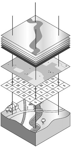
Smart digital maps (as shown in Figure 1-1) may look like static maps, but data is associated with map locations. The data can be as basic as the latitude and longitude of a point, or as detailed about vegetation, soil type, and slope.
Spatial or geospatial data is associated with a place. The place can be smaller than a meter or as large as a country. Spatial data can be stored two ways:
Embedded in a map graphic file
Separate files with references to the locations
TIFF (Tagged Image File Format) is a popular format for storing graphics files. The GeoTIFF extension embeds geographic tags into map images. If you view a GeoTIFF file with a standard graphics program, it looks like an ordinary map. A program that uses the data tags can access the spatial data associated with each pixel in the image.
Figure 1-1:
A smart map has associated data.

