Because the earth isn’t flat, geographic coordinate systems use ellipsoids (think of a sphere that’s not perfectly spherical, much like the shape of the Earth) to calculate positions on our third planet from the sun. A datum is the position of the ellipsoid relative to the center of the earth.
Unless you’re a cartographer or geographer, that probably hurts just thinking about it. Sparing you a long and detailed technical description, here are the two important things that you need to know:
All maps have a datum. Hundreds of different datums are in use. Most good maps used for navigation — and highway maps don’t count — usually state which datum was used in making the map.
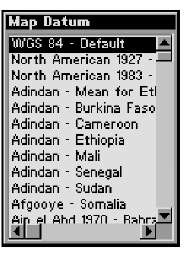
You can set what datum your GPS receiver uses. An example of a GPS map datum page is shown in Figure 4-1.
Figure 4-1:
A GPS receiver map datum page.
The default datum for GPS receivers is WGS 84, more formally known as the World Geodetic System 1984. WGS 84 was adopted as a world standard and is derived from a datum called the North American Datum of 1983.
Most USGS topographic maps that you use for hiking are based on an earlier datum called the North American Datum of 1927, or NAD 27. This datum is divided into different geographic areas, so if you’re in the United States — at least in the lower 48 states — use a version of NAD 27 that mentions the continental U.S.
So why is all this datum stuff so important? In the United States, if a position is saved in a GPS receiver by using the WGS 84 datum and the same coordinates are plotted on a map that uses the NAD 27 datum, the location can be off as much as 200 meters. That’s more than a couple of football fields off. The latitude and longitude coordinates will be identical, but the location is going to end up in two different spots.
Datum lessons learned
Here’s a quick story from my Forest Service fire-fighting days that illustrates the importance of being aware of datums. A fire was reported in a mountainous area of eastern Oregon, and my partner and I helicopter-rappelled in to put out the fire. Because the fire was bigger than expected, we requested some smokejumpers to assist. They were down from Alaska, helping out during the lower 48′s fire season, and they all had new handheld GPS receivers, which were pretty state of the art back then (1998). The fire continued to grow, and we called in a small air tanker to stop the fire’s spread. One of the
Alaska jumpers pulled out his GPS unit, and we called in an exact set of coordinates for the pilot to hit. As the tanker approached, the pilot radioed us, asking whether we were sure that was where we wanted the retardant to go. Turns out that the jumper still had his GPS unit set with an Alaska map datum (that didn’t match the local datum on the pilot’s GPS receiver), and the coordinates that the Bureau of Land Management (BLM) jumper gave were on the other side of the ridge, nowhere near the fire. Fortunately, the pilot used his own initiative and dumped his load right where it needed to go.
The moral of the story is to make sure that the datums on your GPS receiver and maps are the same. Or, if you’re with a group of people using GPS receivers, make sure that all your datums match.
Not having the map datum match the GPS receiver datum is one of the biggest errors that new users of GPS receivers make. I can’t emphasize this point strongly enough: Make sure that the two match!

