Most maps have a scale — the ratio of the horizontal distance on the map to the corresponding horizontal distance on the ground. For example, one inch on a map can represent one mile on the ground.
The map scale is usually shown at the bottom of the map in the legend. Often, rulers with the scale mark specific distances for you. A scale from a USGS topographic map is shown in Figure 2-8.
Many maps use a representative fraction to describe scale. This is the ratio of the map distance to the ground distance in the same units of measure. For example, a map that’s 1:24,000 scale means that one inch measured on the map is equivalent to 24,000 inches on the ground. The number can be inches, feet, millimeters, centimeters, or some other unit of measure.
The units on the top and bottom of the representative fraction must be the same. You can’t mix measurement units.
Figure 2-8:
Scale information in the legend of a USGS 7.5 minute topographic map.
When you’re dealing with scale, keep these guidelines in mind:
The smaller the number to the right of the 1, the more detail the map has.
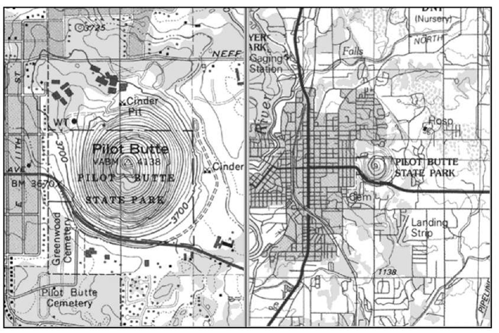
A 1:24,000 map has much more detail than a 1:100,000 scale map. A 1:24,000 map is a large-scale map, showing a small area.
The smaller the number to the right of the 1, the smaller the area the map displays.
In Figure 2-9, the 1:100,000 scale map shows a much larger area than the 1:24,000 scale map. A 1:100,000 map is a small-scale map, showing a large area.
All sorts of rulers and measurement tools are calibrated to scale for measuring distance on paper maps. Mapping software makes distances easier and quicker to determine by offering tools that draw a line between two points and show an exact distance.
Figure 2-9:
1:24,000 and 1:100,000 scale topographic maps show different details and areas.


