GPS users employ differential techniques to achieve the highest possible positional accuracy. A straightforward manner of doing this is to use two GPS receivers, a base and a rover.However, this may not be cost effective in many instances. An alternative, which could significantly reduce the survey cost without degrading the positional accuracy, is to use one of the available GPS data and correction services. If such a service is available within the project area, a GPS user would only need one receiver to be used as a rover; no base receiver is required. A number of various GPS services are currently available with various levels of accuracy and cost. Some services are even provided with no user fees required.
For high-accuracy static positioning, primarily for establishing new control points, GPS users may use one of the highly precise permanent GPS reference station networks established by several organizations around the world. These services are currently available free of charge at the global level [e.g., the International GPS Service for Geodynamics (IGS) network] as well as at the regional level [e.g., the Continuously Operating Reference Station (CORS) network in the United States] [1-3]. The Canadian Active Control System (CACS) is another regional GPS service, which is available to users at nominal fees [4]. The reference stations within these systems are operating on a continuous basis, and provide access to the modern reference frames, such as the ITRF and the improved NAD 83.
Some countries around the world have established networks of reference stations around their coastal areas, which continuously broadcast real-time DGPS corrections in a special format known as the RTCM format.This service is primarily designed to enhance the safety of marine navigation, but is available at no cost to all users within the coverage area. Although this service is available primarily free of charge, it requires a beacon receiver connected to a GPS receiver that accepts the RTCM corrections [5]. GPS receivers that accept the RTCM corrections are commonly known as differential-ready GPS receivers. The accuracy obtained from such a service is usually in the range of a submeter to a few meters.
At the commercial level, two real-time DGPS correction services are widely used. One broadcasts the DGPS corrections through FM broadcast stations, while the other through communication satellites [6-8]. The DGPS corrections from the two systems are based on the DGPS corrections from a network of ground reference stations that cover a wide area, for example, a continent. The system is therefore known as the wide-area differential GPS (WADGPS). Both systems require a special receiver to decode the DGPS correction information, which would be interfaced to the GPS rover receiver to output positional information at the meter-level accuracy. WADGPS systems have several advantages over conventional single-station DGPS systems, including coverage of large, inaccessible regions using fewer reference stations [9].
Multisite, real-time, carrier-phase-based RTK positioning at sub-decimeter-level accuracy is a new service that is currently being developed [10]. With this service, as little as four GPS reference receivers could cover an entire city or even a number of adjacent small cities. Advancements in wireless communication and the Internet are expected to make this service very promising [11]. This topic summarizes each of the GPS services.
Data service
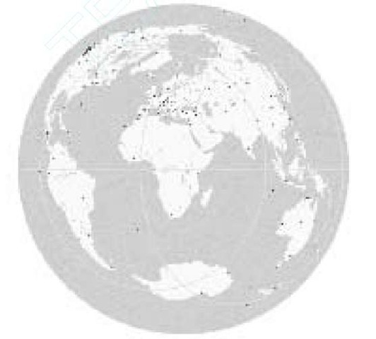
Several organizations around the world have established highly precise permanent GPS reference station networks, which are used for various geodetic purposes. The GPS data collected at these reference stations is made available to users, and could be used for high-accuracy static-positioning operations, such as establishing new control points. One such organization is the IGS, which is a service with international multiagency membership to support global geodetic and geophysical activities [1]. The International Association of Geodesy (IAG) has formally recognized the IGS since 1993. The IGS service is accomplished through a global network of 250 tracking stations (as of April 2001) equipped with continuously operating dual-frequency receivers and a number of data and analysis centers. Figure 7.1 shows the current IGS tracking stations.
The raw GPS data collected at each tracking station is formatted in a standard format, called the Receiver Independent Exchange (RINEX),by the operational data centers. The formatted data is then collected by the global data centers for archiving and providing online accessibility. At this stage, the analysis centers use the on-line data to create a number of products. These products include GPS precise ephem-eris, satellite and tracking station clock information, tracking station coordinates and velocities, and Earth rotation parameters. There are different quality levels for the precise ephemeris, depending on the time of availability.
Figure 7.1 IGS tracking stations.
IGS GPS data and products are currently available, at no cost, to users worldwide through the Internet.The data is available in the standard RINEX format. It should be pointed out that both the IGS precise ephemeris and the tracking station coordinates are referred to the ITRF reference system. That is, if a user employs the IGS precise ephemeris, his or her solution coordinates will be referred to the ITRF reference system. In North America, users could also access GPS data through the CORS and CACS networks, which are operated by the U.S. NGS and Geomatics Canada, respectively [3, 4]. One advantage of using CORS and CACS data is that the reference stations are relatively closer to each other. Additionally, the precise ephemeris and the coordinates of the reference stations may be obtained in either of the ITRF or the improved NAD 83 systems.
DGPS radio beacon systems
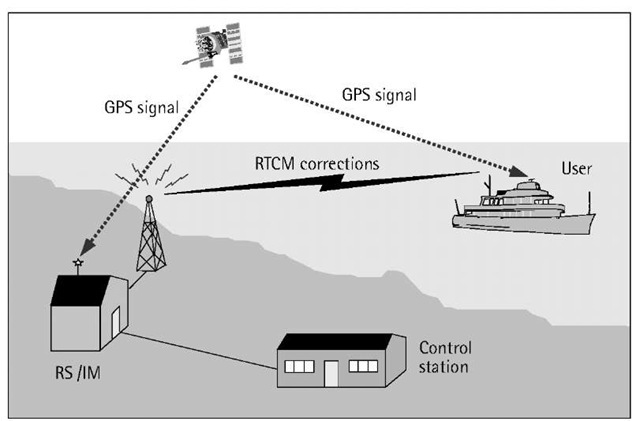
Marine radio beacons are electronic aids to navigation that operate in the low-to-medium frequency band of283.5-325 kHz [5]. They are installed at lighthouses and other coastal locations. To enhance maritime safety, a number of marine radio beacons throughout the world have been modified to broadcast real-time DGPS corrections in the RTCM format (see Figure 7.2). This service is available at no charge in most cases.
In the DGPS beacon system, a reference station (RS) creates the realtime DGPS corrections in the RTCM format as discussed.These corrections are digitally modulated using a special form of frequency modulation known as minimum shift keying (MSK). The modulated correction data is then transmitted from the radio beacon at rates between 25 and 200 bps [5]. Typical rates, however, are 100 and 200 bps. In most of the cases, an integrity monitoring (IM) unit is colocated with the RS to monitor its performance (see Figure 7.2).
A user equipped with an MSK beacon receiver can receive the transmitted DGPS corrections as long as he or she is within the coverage area of a particular beacon station. The coverage depends, among other factors, on the transmitter power output, the atmospheric noise, and the receiver sensitivity. The coverage also depends on the characteristics of the propagation path or conductivity; it is greater over water than inland. Beacon locations are usually selected to provide overlapping coverage to increase the overall signal availability.
Figure 7.2 DGPS beacon service.
The service provider (e.g., the coast guard of a particular country) usually publishes the expected coverage area of a DGPS beacon system. Some manufacturers of the radio beacon receivers publish detailed information about the availability of the beacon service worldwide.
It should be pointed out that MSK beacon receivers are available as single- or dual-channel receivers. The latter are more expensive, but more reliable. The second channel is useful when searching for an adjacent beacon station, if available, with a better signal quality. The receiver will automatically switch to the adjacent beacon station once it is found. Evidently, if an area is known to be covered by one beacon station only, a single-channel MSK receiver would be enough and more cost-effective. To be useful, the MSK receiver should be interfaced to a differential-ready GPS receiver, which would then output the corrected station coordinates.
Wide-area DGPS systems
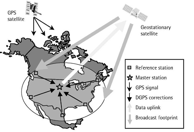
Real-time DGPS with a single reference station has the disadvantage that the positioning accuracy tends to deteriorate as the user moves away from the reference station. That is, the highest positioning accuracy is limited to the relatively small area surrounding the reference station. To overcome this problem, a system based on a number of widely separated reference stations, known as WADGPS, has been developed [9]. With this system, the reference stations collect and preprocess the GPS data to compute the DGPS corrections, which are then forwarded to a master station via terrestrial links such as fiber optic cables. The master station analyzes and combines the received data to determine a number of correction parameters for each GPS satellite, which would be valid within the system coverage area (see Figure 7.3). These parameters are packed and uploaded into a geostationary satellite, which rebroadcasts them back to the Earth to ensure a wide coverage. A user within the system coverage area will receive only one set of DGPS corrections, which is valid for his or her location.
A number of commercial WADGPS systems are currently available, including OMNISTAR and RACAL LandStar [7, 8]. Both of these systems use satellite data link and cover various regions of the world (see Figure 7.3). The OMNISTAR service operates in the C-band of the frequency spectrum, while the LandStar service operates in the L-band. To access either service, a subscriber needs the system data receiver to receive and decode the DGPS corrections. The data receiver must be interfaced to a differential-ready GPS receiver to obtain the corrected position. Accuracy of the order of a submeter to a few meters can be obtained, depending mainly on the GPS receiver type.
To reduce the cost of the WADGPS service, some service providers have developed an alternative way of broadcasting the real-time DGPS corrections of their WADGPS system [6]. The system is based on using the already existing FM radio broadcasts to deliver the DGPS corrections to local users (Figure 7.4). That is, the correction parameters transmitted by the geostationary satellite will be received by a number of FM broadcast stations, which will then compute and broadcast the DGPS corrections to the local users. A technology known as radio data system (RDS) allows the FM radio broadcasts to carry the digital DGPS corrections information. To access a service of this type, a subscriber within the coverage area of the FM radio broadcast needs an RDS FM receiver to construct the DGPS corrections.Accuracy of the order of 1m to 10m can be obtained, depending mainly on the subscription option and the GPS receiver type. This system has the advantage that the subscription fee as well as the FM receiver cost are low compared with the satellite-based broadcast service. It suffers, however, from the limited service coverage of the FM broadcast stations. Reported North American coverage is about 90% of the populated areas.
Figure 7.3 Principle of WADGPS system.
Figure 7.4 Distribution of WADGPS corrections through FM broadcast stations.
Multisite RTK system
Beyond this distance limit, the errors at the reference and the rover receivers become less correlated (i.e., dissimilar) and would not cancel out sufficiently through the double differencing [10]. This leads to unsuccessful fixing for the ambiguity parameters, which in turn deteriorates the positioning accuracy. To overcome this limitation, research groups have developed multisite real-time, carrier-phase-based RTK positioning [10].
The idea behind multisite RTK positioning is based on using a network of reference stations to create raw GPS measurements for a virtual reference station, which is located very close to the mobile, or the rover, receiver. Once created, the virtual reference station measurements are transmitted to the mobile receiver, where the normal single reference station RTK positioning can be performed. The way the virtual reference station measurements are created can be summarized as follows. First, the differential errors between the reference stations within the network are determined, based on their known precise coordinates. The differential errors at any point within the network (e.g., a mobile receiver’s location) can then be determined by interpolation. Once the mobile user provides his or her approximate position to the control station, the differential errors at that location are determined. The raw measurements are then created based on the differential errors and the approximate position of the mobile user [10].
Other forms of multisite RTK positioning have also been developed. The principle, however, remains similar to the virtual reference station technique. It should be pointed out that multisite RTK positioning is growing fast. The recent developments in Internet and wireless communication technologies make this service very promising [11].


