To describe the motion of the GPS satellites, an inertial coordinate system has to be defined. The motion of the satellites follows the Newtonian mechanics, and the Newtonian mechanics is valid and expressed in an inertial coordinate system. For reasons, the Conventional Celestial Reference Frame (CRF) is suitable for our purpose. The xy-plane of the CRF is the plane of the Earth’s equator; the coordinates are celestial longitude, measured eastward along the equator from the vernal equinox, and celestial latitude. The vernal equinox is a crossover point of the ecliptic and the equator. So the right-handed Earth-centred inertial (ECI) system uses the Earth centre as the origin, CIO (Conventional International Origin) as the z-axis, and its x-axis is directed to the equinox of J2000.0 (Julian Date of 12h 1st January 2000). Such a coordinate system is also called equatorial coordinates of date. Because of the motion (acceleration) of the Earth’s centre, ECI is indeed a quasi-inertial system, and the general relativistic effects have to be taken into account in this system. The system moves around the Sun, however, without rotating with respect to the CIO. This system is also called the Earth-centred space-fixed (ECSF) coordinate system.
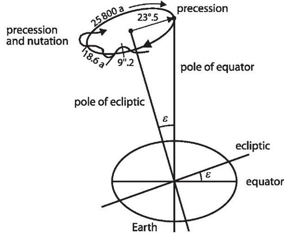
An excellent figure has been given by Torge (1991) to illustrate the motion of the Earth’s pole with respect to the ecliptic pole (cf., Fig. 2.6). The Earth’s flattening, combined with the obliquity of the ecliptic, results in a slow turning of the equator on the ecliptic due to the differential gravitational effect of the Moon and the Sun. The slow circular motion with a period of about 26 000 years is called precession, and the other quicker motion with periods from 14 days to 18.6 years is called nutation. Taking the precession and nutation into account, the Earth’s mean pole (related to the mean equator) is transformed to the Earth’s true pole (related to the true equator). The x-axis of the ECI is pointed to the vernal equinox of date.
The angle of the Earth’s rotation from the equinox of date to the Greenwich meridian is called Greenwich Apparent Sidereal Time (GAST). Taking GAST into account (called the Earth’s rotation), the ECI of date is transformed to the true equatorial co-ordinate system.
Fig. 2.6.
Precession and nutation
The difference between the true equatorial system and the ECEF system is the polar motion. So we have transformed the ECI system with a geometric way to the ECEF system. Such a transformation process can be written as
where![]() is the precession matrix,
is the precession matrix,![]() is the nutation matrix,
is the nutation matrix,![]() is the Earth rotation matrix,
is the Earth rotation matrix,![]() is the polar motion matrix, X is the coordinate vector, and indices ECEF and ECI denote the related coordinate systems.
is the polar motion matrix, X is the coordinate vector, and indices ECEF and ECI denote the related coordinate systems.
Precession
The precession matrix consists of three succeeded rotational matrices, i.e., (cf., e.g., Hofman-Wellenhof et al. 1997; Leick 1995; McCarthy 1996)
where
are precession parameters and
where T is the measuring time in Julian centuries (36 525 days) counted from J2000.0 (cf., Sect. 2.6 time systems).
Nutation
The nutation matrix consists of three succeeded rotational matrices, i.e., (cf., e.g., Hoffman-Wellenhof et al. 1997; Leick 1995; McCarthy 1996)
where![]() is the mean obliquity of the ecliptic angle of date,
is the mean obliquity of the ecliptic angle of date,![]() are nutation angles in longitude and obliquity,
are nutation angles in longitude and obliquity,![]() and
and
The approximation is made by letting![]() for very small
for very small
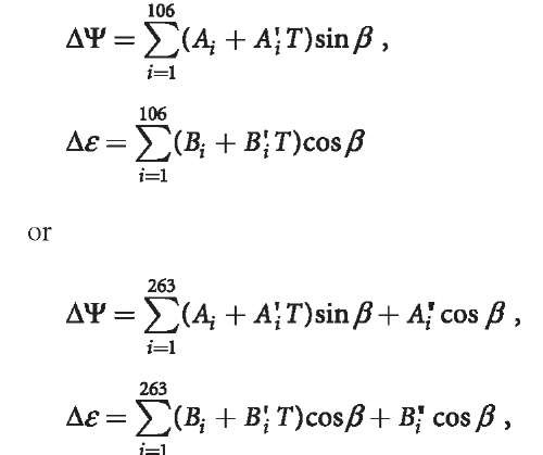
![]() For precise purposes, the exact rotation matrix shall be used. The nutation parameters ,
For precise purposes, the exact rotation matrix shall be used. The nutation parameters ,![]() can be computed by using the International Astronomical Union (IAU) theory or IERS theory:
can be computed by using the International Astronomical Union (IAU) theory or IERS theory:
where argument
where l is the mean anomaly of the Moon, l is the mean anomaly of the Sun,![]() D is the mean elongation of the Moon from the Sun,
D is the mean elongation of the Moon from the Sun,![]() is the mean longitude of the ascending node of the Moon, and L is the mean longitude of the Moon. The formulas of
is the mean longitude of the ascending node of the Moon, and L is the mean longitude of the Moon. The formulas of![]() , are given in Sect. 11.2.8. The coefficient values of
, are given in Sect. 11.2.8. The coefficient values of
![]() can be found in, e.g., McCarthy (1996). The updated formulas and tables can be found in updated IERS conventions.
can be found in, e.g., McCarthy (1996). The updated formulas and tables can be found in updated IERS conventions.
Earth Rotation
The Earth rotation matrix can be represented as
where GAST is Greenwich Apparent Sidereal Time and
where GMST is Greenwich Mean Sidereal Time.![]() is the mean longitude of the ascending node of the Moon; the second term on the right-hand side is the nutation of the equinox. Furthermore,
is the mean longitude of the ascending node of the Moon; the second term on the right-hand side is the nutation of the equinox. Furthermore,
where ‘![]() is Greenwich Mean Sidereal Time at midnight on the day of interest.
is Greenwich Mean Sidereal Time at midnight on the day of interest.
UT1 is the polar motion corrected Universal Time (cf., Sect. 2.6). ![]() is the measuring time in Julian centuries (36 525 days) counted from J2000.0 to
is the measuring time in Julian centuries (36 525 days) counted from J2000.0 to ![]() of the measuring day. By computing GMST, UT1 is used (cf., Sect. 2.6).
of the measuring day. By computing GMST, UT1 is used (cf., Sect. 2.6).
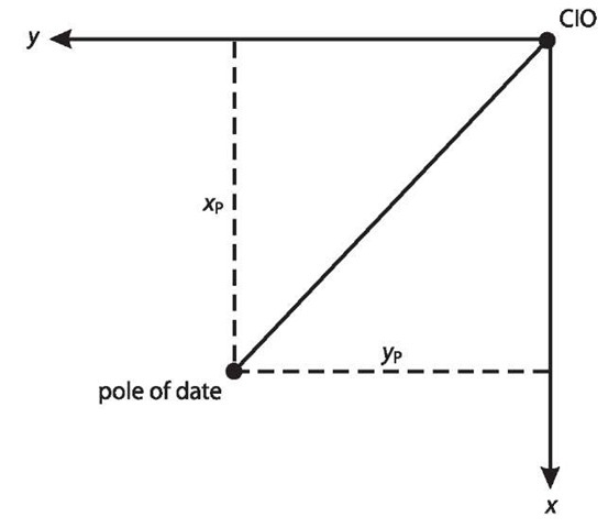
Fig. 2.7.
Polar motion
Polar Motion
As shown in Fig. 2.7, the polar motion is defined as the angles between the pole of date and the CIO pole. The polar motion coordinate system is defined by xy-plane coordinates, whose x-axis is pointed to the south and is coincided to the mean Greenwich meridian, and whose y-axis is pointed to the west. xp and yp are the angles of the pole of date, so the rotation matrix of polar motion can be represented as
The IERS determined xp and yp can be obtained from the home pages of IERS. 2.5


