IN WHICH we take a closer look at the subject of GPS accuracy and explore techniques that reduce errors.
OVERVIEW
GPS Accuracy in General
When you record a single position with a good GPS receiver, the position recorded will probably be within 5 to 15 meters horizontally of the true location of the antenna.
When a surveyor uses good, survey-grade GPS equipment he or she can locate a point to within a centimeter of its true horizontal position. What are the factors that allow the surveyor to be 1,000 or so times more accurate than you are? This is a complicated subject. The answer includes "very good equipment," "measuring the actual number of waves in the carrier" (as differentiated from interpreting the codes impressed on the carrier), and "spending a lot of time" at each site.1 We can cover only the basics in a topic of this scope. But you will learn how to reduce errors so that you can record a fix to within half a meter to three meters of its true location. One primary method of gaining such accuracy is called "differential correction."
Differential Correction in Summary
In a nutshell, the differential correction process consists of setting a GPS receiver (called a base station) at a precisely known geographic point. Since the base station knows exactly where its antenna is, it can analyze and record errors in the GPS signals it receives—signals that try to tell it that it is somewhere else. That is, the base station knows the truth, so it can assess the lies being told to it by the GPS signals. These signal errors will be almost equivalent to the signal errors affecting other GPS receivers in the local area, so the accuracy of locations calculated by those other receivers may be improved, dramatically, by information supplied by the base station.
Thinking about Error
For the logging of a given point, define "error" as the distance between what your GPS receiver records as the position of the antenna and the true position of the antenna.
It is useful to dissect the idea of "error." We can speak of error in a horizontal plane and differentiate it from the vertical error. This is important in GPS, because the geometry of the satellites almost always dictates that no matter what we do, vertical error will almost always exceed horizontal error on or near the surface of the earth. The fact that all the satellites are necessarily above the fix being taken generally means that vertical error will be 1.5 to 2.5 as great as horizontal error.
Another useful distinction is between what we might call random error and systematic error, or bias. Random errors are deviations from a "true" value that follow no predictable pattern. Systematic errors do follow a predictable pattern. An example will be illustrative. Suppose we have a machine designed to hurl tennis balls so that they land a certain distance away on a small target painted on the ground. Of course, none of the balls will hit the center of the target exactly; there will always be some error.
What factors might cause errors? The balls are each of slightly different weight; they are not symmetrical and will be loaded into the machine in different orientations. Since it is hard to determine the effects of these factors on the accuracy of the process, we say the factors induce random errors. If there are only random errors in the process, some balls will hit short of the center of the target, some beyond it, some left, some right, and so on. If we shoot 100 balls from the machine we will see a pattern of strikes in the area of target which appears somewhat random, but which clusters around the target.
Now suppose that we had set up our machine and its target when there was no wind, but then a constant breeze of 10 miles per hour began blowing from the right across the path of flight of the tennis balls. This would create a systematic error: each ball would land somewhat to the left of where it would have landed in the no-wind condition. We will still see a random pattern of hits, but the average of all hits will be somewhat to the left of the target. This is systematic error; the "system," including the wind, causes it. To correct, we could aim the machine somewhat to the right.
Other examples of factors that might contribute to errors are: as the temperature changes, the characteristics of the machine may change; the atmospheric pressure and the relative humidity of the air will affect the drag on a ball; and so on. Whether these might be random errors or systematic ones might be hard to determine.
Generally, random errors are those caused by factors we cannot measure or control; systematic errors are those we can account for, measure, and, perhaps, correct for.
First Line of Defense against Error: Averaging
When I implied that the surveyor could be 1,000 times more accurate than the average person with a GPS receiver, I was being somewhat disingenuous, mostly for effect. I was comparing a single reading with inexpensive equipment with the average of many readings from expensive equipment. This is not a fair contrast, since you can improve the accuracy of the less expensive equipment by taking many readings at a fixed point. You recall that the strikes of the tennis balls, with no wind, tended to cluster around the target. GPS readings tend to cluster around the true location. We can use the fact that large numbers of random errors tend to be self-canceling. That is, the average position (if you take the means of many latitudes, of many longitudes, of many altitudes) will be much closer to the true value than the typical single measurement.
One measure of accuracy of GPS fixes is called Circular Error Probable (CEP). It is the radius of a circle expressed in a linear unit, such as meters. For a given situation, 50% of the fixes will fall within the circle, and 50% outside. Another measure of accuracy is based on two standard deviations of a normal distribution—called 2dRMS where RMS means root-mean-square.
Ninety-five percent of the fixes will lie within a circle with this radius.
For NAVSTAR GPS, a number of experiments suggest that 50% of the latitude and longitude fixes you obtain with a single receiver operating by itself (i.e., autonomously) will lie within 12 meters of the true point. Fifty percent of the altitude fixes will lie within 21 meters. The 2dRMS radius is 30 meters horizontally, and 70 meters vertically. These numbers assume that selective availability is off.
In general, the more fixes you take and the more time you spend, the better your average will be. If you are prepared to take data at one point for several weeks to several months your error will get down to approximately one to two meters, basically due to the law of large numbers.2 This may not be a practical way to reduce error in most applications.
Another approach, which is related to averaging in a different way, is to use "over-determined" position finding. As you know, four satellites are required for a 3-D fix. But suppose your receiver has access to five or more at a given time. Each set of four of the satellites available will provide a different opinion on the position of the point being sought. A compromise agreement based on all the satellites’ input is probably better than the position indicated by any one set of four. The GeoExplorer may be set to collect data in this way.
Sources of GPS Error
Now look at the specific sources of errors in GPS measurements. Typical error sources and values for receivers of the Pathfinder class are:
|
satellite clocks |
<1 meter |
|
ephemeris error |
<1 meter |
|
receiver error |
<2 meters |
|
ionospheric |
<2 meters |
|
tropospheric |
<2 meters |
|
multipath |
(depends on the situation and the receiver; may be large) |
These values correspond to averages of many readings rather than the error that might be expected from a single reading. Although experimentation shows that the more fixes you record the better the data become, the increase in accuracy created by taking a large number of fixes really cannot be counted upon. The existence of systematic errors that might be present because of particular atmospheric conditions (or, for certain, when selective availability was active) makes the law of large numbers inapplicable. As you will see shortly, there are better ways to get really accurate data. And much more accurate data are almost always required when using GPS for GIS purposes.
Clock Errors
As you know, the ability of a GPS receiver to determine a fix depends on its ability to determine how long it takes a signal to get from the satellite to the receiver antenna. This requires that the atomic clocks in the satellite be synchronized. Even a small amount of difference in the clocks can make a huge difference in the distance measurements, because the GPS signal travels at about 300,000,000 meters per second.
Ephemeris Errors
The receiver expects each satellite to be at a certain place at a particular given time. Every hour or so, in its data message, the satellite tells the receiver where it is predicted to be at time "t" hence. If this ephemeris prediction is incorrect—the satellite isn’t where it is expected to be, even by just a meter or two—then the measurement of the range from the receiver antenna to the satellite will be incorrect.
Receiver Errors
These errors result from a number of factors related to receiver design, cost, and quality. Some receivers, for example, cannot exactly measure and compute the distance to each satellite simultaneously. The GeoExplorer can track up to six satellites at a single moment; it is a six-channel receiver. In any receiver the computer must work with a fixed number of digits and is therefore subject to calculation errors. The fact is, perfection in position calculation by computer simply is not possible, because computers cannot do arithmetic on fractions exactly. (It is true that other computer operations, such as addition of integers, are perfect.)
Atmospheric Errors
For most of its trip from the satellite to the receiver antenna, the GPS signal enjoys a trip through the virtual vacuum of "empty space." Half of the mass of the earth’s atmosphere is within 3.5 miles of sea level. Virtually all of it is within 100 miles of the surface. So the signal gets to go the speed limit for electromagnetic radiation for more than 12,000 of the more than 12,600 miles of the trip. When it gets to the earth’s atmosphere, however, the speed drops very slightly—by an amount that varies somewhat randomly. Of course, since the calculation of the range to the satellite depends on the speed of the signal, a change in signal speed implies an error in distance, which produces an error in position finding.
Significant changes in signal speed occur throughout the atmosphere, but the primary contributions to error come from the ionosphere, which contains charged particles under the influence of the earth’s magnetic field, and from the troposphere—that dense part of the atmosphere that we breath, that rains on us, and that demonstrates large variations in pressure and depth.
More sophisticated GPS equipment can "calculate out" most of the ionospheric error because it considers both the frequencies transmitted by each satellite. Since the ionosphere affects the different frequencies differently a correction can be calculated. Tropospheric errors, however, we seem to be pretty much stuck with, especially using the moderately inexpensive code-based equipment available to civilians. This will change when a second civilian signal is added to the system.
Multipath Errors
This can happen if a part of the signal is bounced off an object, such as a building. The arrival of two or more parts of the signal at different times can confuse the receiver and produce a false reading. Many receivers are programmed to disregard the second signal. But a problem can occur if the direct signal is blocked but the related bounced signal is seen by the antenna and recorded.
Selective Availability—A Former (We Hope) Source of Error
Until May 2, 2000 the lion’s share of the "Error Budget" came from deliberate corruption of the signal by the U.S. Department of Defense (DoD). As I have said, they didn’t want the civilian GPS receiver to be able to pinpoint its position. In fact, in the early days, they didn’t want the civilian world to know GPS existed. Selective availability was one technique the military could use to keep the system from being too accurate. (Another is called "antispoofing.") The errors were probably induced by dithering (making inaccurate) the signal that tells the ground receiver the exact time or by broadcasting a slightly false ephemeris. Obviously, the military didn’t want to say too much about its techniques for making the good GPS signals "selectively available"—i.e., available only to military receivers.
The DoD had, on occasion, turned selective availability off before. (Two notable times were during the Mideast War with Iraq and during the almost-invasion of Haiti.)
With SA off an autonomous receiver can supply much more accurate position information. The 50% measure (CEP) measure is about 12 meters horizontally and 21 meters vertically, due to the errors previously discussed. Ninety-five percent (2dRMS) of the fixes fall within 30 meters horizontally, and 52 meters vertically.
Reducing Errors
As it turns out, most of these errors can be "calculated out" of the measurements by the process called differential correction. To understand how it works, let me first show you the results of an experiment.
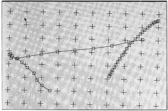
Figure 4—13 shows two sequences of points (two different files) taken with a GeoExplorer receiver placed at a single location, operating during two different time periods.
The neat string at right was made of fixes taken about 6 seconds apart; the mess at the left was measured by taking points every 20 seconds during a different time period. (The tick marks are 10 meters apart.) You should realize that each and every fix here is attempting to approximate the same true position. They show up in different positions because of the errors discussed above. We don’t know what the true position of the antenna was, but almost certainly each point misses the exact, true position by some amount.
Figure 4-1. Two files of the same point data (GeoExplorer).
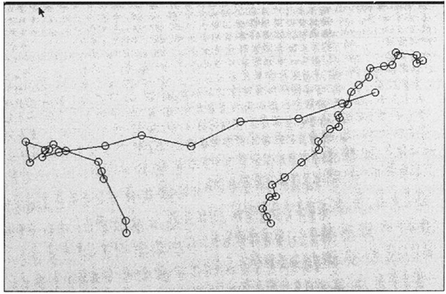
Figure 4—2 shows data collected at the same times as in the previous figure; the computations of location were based on the same set of four satellites. The antenna for this receiver (a Pathfinder Basic) was in virtually the same geographic location as the other.
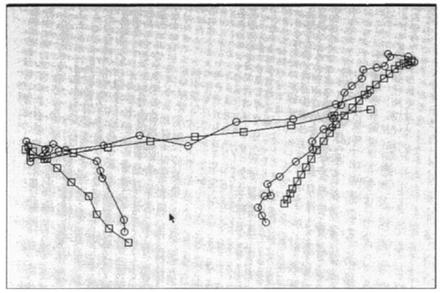
Now look at a composite of the two sets of data as shown in Figure 4—3. The points of the GeoExplorer data are marked with boxes; the Pathfinder data are marked with circles.
What is interesting is that the two patterns of fixes show remarkable similarity. Pairs of fixes—taken at the same time from the same set of satellites—appear in about the same position. This suggests that the error for each associated pair of points is almost identical, even though the fixes have come from different receivers and different antennas. And this suggests something which turns out to be true, though I have not proved it here: that receivers calculating from the same signals will suffer from almost the same errors, provided that the antennas are "close." What’s close? Two receivers within 500 kilometers (300 miles) will tend to show the same magnitude and direction of errors with respect to the true locations of their antennas, provided the positions are found using the same set of satellites.
Figure 4-2. Same point as previous figure (Pathfinder Basic).
More Formally
The experiment described above demonstrates that much of the error is inherent in the signals—that is, the errors occur before the signals reach the receiver antenna.
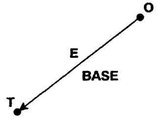
To see how that helps us remove most of the error from a GPS fix, let’s focus on both a single point on Earth’s surface (a true point, "T"), and its representation in the GPS receiver (the measured, or observed, point, "O").
Suppose we take a GPS receiver antenna, and place it precisely at that known point "T"—a point that has been surveyed by exacting means and whose true position is known to within a centimeter. We call such an antenna-receiver configuration GPS base station.
Figure 4-3. Composite of four files; same antenna locations.
Figure 4-4. Error vector—from observed point to true point.
Now consider that an observation "O" is taken by a base station receiver. So we have three entities to consider, as shown in Figure 4—4:
• the position of "T,"
• the reading "O," and
• the "difference" between "O" and "T."
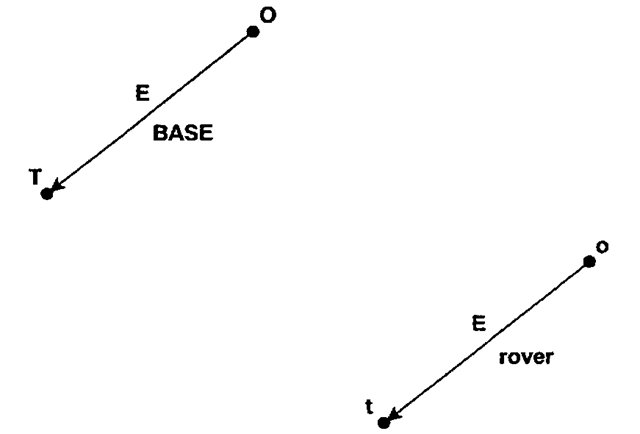
We’ve drawn an arrow from the measured point to the true point. This arrow, which is shown in two dimensions but which would really exist in three, has both a length (called a magnitude) and a direction. An entity that has magnitude and direction is known as a vector. We label the vector "E," for "error," because it represents the amount and direction by which the reading missed the true point. Usually we don’t know E, but here we can calculate it. The following discussion indicates how.
In general, when we have used GPS, we have used the reported coordinates, "O," as an approximation of "T." The vector "E" was the (unknown) amount by which we missed determining the position "T." As an equation we could write: where we record "O" and we disregard "E" to find an approximation of "T." That is, the true coordinates are the observed coordinates minus the error. At best, we could estimate the magnitude—but not the direction—of "E." (It is important to realize that none of these quantities are scalars [simple numbers like 23.5] but are three-dimensional entities, so the "-" sign indicates vector subtraction. The concept we are attempting to communicate survives this complexity.)
But if we know "T" exactly, and of course we have the measured value "O," then we can rewrite the above equation to find "E":
What good is being able to calculate "E"? It allows us to correct the readings of other GPS receivers in the area that are collecting fixes at unknown points.
We demonstrated above, with Figures 4—1, 4—2, and 4—3, that if two GPS receiver antennas are close, and use the same satellites, they will perceive almost the same errors. That is, for any given point at any given moment, "E" will be almost exactly the same for both receivers. Thus, for any nearby point reported by a GPS receiver as "o," its true value "t" can be closely approximated simply by applying the equation:5
Since both "o" and "E" are known, the error is effectively subtracted out, resulting in a nearly correct value for "t," as shown by Figure 4—5.
This technique provides an opportunity for canceling out most of the error in a GPS position found by an antenna that is close to another antenna which is over a known point. As I mentioned before, "close" is about 500 kilometers or 300 miles.
Figure 4-5. Know error vector applied to point observed by rover.
The formula for the amount of error you might expect with differentially corrected data is dependent on the distance between the base station antenna and the rover antenna. A rule of thumb is that the fix will be in error by one additional centimeter for each three kilometers between the two antennas. This relationship is approximately linear: 300 kilometers would produce error of about a meter.
