Geoscience Reference
In-Depth Information
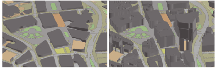
Fig. 3
3D Dataset for Sheffield, showing detailed LoD 1 data (
top
) and generalised data
(
bottom
)
2.4 Combining Architectural Considerations, User
Interaction and Support for Spatial Literacy
From the description above it can be seen that a 3D mobile App should combine a
wide range of user interaction (swiping, tapping, pinch-zooming) in a timely fashion,
with support for spatial literacy (e.g. showing key features and land marks to permit a
user to orientate themselves in the scene) and display of data in a timely fashion but
also to a level of detail appropriate to the user's view extent (scale) and task, while per-
mitting the user to visualise additional off-screen data rather than limiting their view.
The remainder of this chapter compares two approaches to achieving optimal
interaction and performance times while also considering the need for support
for improved spatial literacy and viewing a wider extent of the data. To achieve
this, we compare the process of downloading an entire 3D model into memory
on a device and permitting user interaction with the entire model with download-
ing scale-specific data in smaller chunks with generalised data provided when the
user is working at smaller scales and detail being shown at larger scales—i.e. mak-
ing use of the multi-scale dataset approach suggested by Hildebrandt and Timm
(
2013
). Initial download time and subsequent zoom and pan times are compared.
3 Test Data
The data used for testing has been provided by the Ordnance Survey (the UK National
Mapping Agency) and consists of a 3D dataset for the UK city of Sheffield. The data
is based on the Ordnance Survey's 2D topographic mapping dataset, Mastermap,
(Ordnance Survey
2013
) and covers an area of approximately 1 km by 1 km. Height
information is available for all buildings in the city, permitting the data to be extruded
to generate LoD 1 buildings. To examine the impact of generalisation, a second data-
set has been generated by generalising the 2D data and extruding it to a standard
height of 10 m. An extract of both datasets (showing Mastermap topographic base
mapping) is shown in Fig.
3
. Table
1
gives details of the resulting datasets.