Geoscience Reference
In-Depth Information
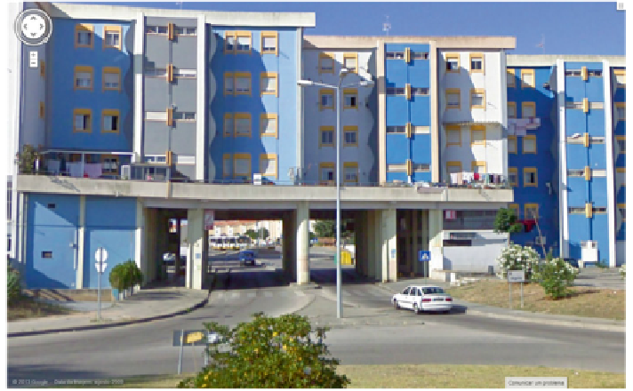
Fig. 9
Complex 3D cadastre occurrences in Coimbra (Portugal): arch-building of apartments
(private property units) over an urban road (public space)—(
source
GoogleEarth)
computerised cadastral system be capable of handling exceptions to the cadastral
law like this one?
3.3.2 Preliminary Case Study Implementations
In this section, details on the design and technical implementation of the case stud-
ies afore identified are described. For illustration purposes, we shall present results
obtained for case study 6 given the fact that this was the one that possibly raised
more interesting issues worthy of being discussed.
The Land Administration Domain Model (LADM) was developed by the
Technical Committee 211 (TC211) as an international standard at the International
Standardization Organisation (ISO), and has been finally approved by ISO on 1
st
November 2012 (Bydłosz
2012
). LADM provides reference models, terminology
and solutions for land administration system modelling. It also gives the refer-
ence representation of spatial units (both 2D and 3D) and solutions to represent
space that is situated in the threshold between 2D and 3D parcels (Bydłosz
2012
;
ISO/TC211
2012
). The conceptual model schema provided by LADM consists of
five main packages (ISO/TC211
2012
; Bydłosz
2012
; Lemmen
2012
; Lemmen
et al.
2010
):
• Parties (people and organisations)
• Rights, responsibilities and restrictions (RRR)
• Spatial units (parcels, buildings etc.)