Geoscience Reference
In-Depth Information
Fig. 1
Continuum of geographic rigour and of “real feel”
1.2 Aims
The ultimate purpose of this project is to determine the feasibility of using the Virtual
Reality (VR) technology that is geographically supported, is graphically realistic
(and enables remote collaboration) as a primary tool for urban planning and design.
Therefore,
the major research objective is the comparative usability assessment
of proposed urban planning scenarios realised by CAD, GIS and online VR
software.
Efficiency, effectiveness and satisfaction dimensions of usability will be
tested. To meet this objective, the
building and testing of 3D environments based
on a proposed urban (subdivision) development (containing existing buildings and
potential developments) will be carried out
. An account of this will be provided
in the methods section. This is while applying
a rendering method to improve the
realism of the VE, particularly the quality of the building models, that can work
effectively for urban planners in real time
. Also, the effects of
improving the
transfer of geographic data into the environment
(via georeferenced orthophotos)
were of interest, especially in the role of virtual navigation.
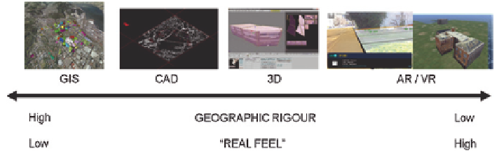
To say a bit more about the technologies involved, if you placed them on a
continuum (Fig.
1
), GIS is at one end, providing georeferencing, spatial analysis,
modelling, storage and visualisation tools geared towards the capturing of a true
geography. At the other end are virtual reality (VR) (and associated technologies such
as augmented reality), less concerned with real-world geography but led by an over-
riding aim to make the user of the technology somehow feel present in a realistic-
looking visually modelled world whether real or imagined. Although the visualisation
and cartographic tools in a GIS can produce excellent 2D maps and effective 3D rep-
resentations, they are somewhat abstracted from the sense of presence (or “real feel”)
engendered by VR/AR technologies. Other geospatial technologies of relevance
to urban planners, such as CAD and 3D modelling packages, fit between these two
extremes on the continuum. Shepherd and Bleasdale-Shepherd (
2012
) presented a
related taxonomy, with GIS at the “symbolic representation” end of a visual appear-
ance continuum, with virtual worlds at the opposing “naturalistic representation” end.
In the study, tasks and a questionnaire were set for the participants, all of which
were practicing or training in the urban planning field. The results of the study will be
presented later on in the paper, followed by a discussion and concluding statements.