Geoscience Reference
In-Depth Information
Usage
Visualization
Technique
usage
...
...
context
Context
Task
viewpoint
spatialConfguration
displayType
ReadValue
ReadText
Estimate
Find...
Compare ...
navigationSpace
cityModel
CityModel
SpatialObject
geoName
LOD
modelURL
...
...
MultiPoint
MultiCurve
MultiSurface
MultiSolid
Grid
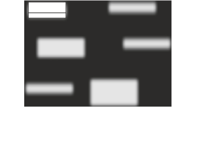
Fig. 6
Usage
representation
we started from the work performed by Lee et al. (
2006
). We then adapted the
tasks defined by the authors (1) according to the data type (text, numeric data) and
(2) according to what is really expected as result. Indeed, we may want to deter-
mine the exact value of the data that is presented, or determine approximately its
value (by placing it in a range of values), or determine which values are the larg-
est or the smallest ones. Thus we have defined the following tasks:
ReadValue,
ReadText, Estimate, Compare
, etc.
The contexts most commonly encountered in the 3D urban models studied
are usually not defined in a formal and precise way. In order to define such con-
texts we started from previous work (Tyndiuk
2005
; Vaaraniemi et al.
2013
).
We thus have the following elements: a spatial configuration and a viewpoint
(
Bird's eye view
,
Pedestrian level
). We then added two more elements: a navi-
gation space describing the characteristics of the navigation and a city model.
The navigation can be free or restricted to a navigation space (
SpatialObject
).
The
CityModel
class describes the characteristics of the 3D city model (in terms
of level of details, geographic name, location, etc.). We also have an attribute
describing the display type. Indeed, the outcome of the evaluation of a tech-
nique may significantly differ, depending on the context. The
Usage
class is
represented in Fig.
6
.
Figure
7
shows a technique that has been defined for reading texts when
navigating at pedestrian level along curves.