Geoscience Reference
In-Depth Information
Fig. 5
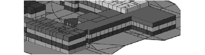
3D spatial model
as ownership number, ownership name, IC number, state and ownership type.
Navigation between cells and queries like neighborhood cells (neighbourhoods of
an interested ownership) of an interested cell can be answered by dual concepts.
Overlapping problem between cells (overlapping between ownerships) can be
solved by defining proper tolerance for coordinates of nodes and optimizing accu-
racy of 3D models to an acceptable range suitable for cadastre. Error estimation
was considered to create a precise and consistent 3D model suitable for 3D cadas-
tre. Final 3D model consists of valid cells (geometry) which are connected prop-
erly (topology) modelled by DHE data structure with proper associated attributes
required for cadastre (see Fig.
5
).
5 Preliminary Results
Captured data has been modelled to compare the results of each method. Using
LaserAce 1000, 3D data capturing and 3D data modelling were simultaneously
done. The rangefinder was connected to a laptop via Bluetooth; corners of rooms
were captured; data was modelled on site. 3D buildings have been modelled using
DHE. Time and cost were the most important factors to be considered. Figure
6
shows the 3D visualization of the 3D model.
The results obtained from the three measuring devices were compared. Figure
7
shows three 3D models reconstructed from data collected using different devices.
Data was collected in two rooms, processed and modelled. The surface area,
cost and time for data collection were compared. Initial comparisons of these
devices are shown in Figs.
8
,
9
and
10
. LaserAce 1000 gave a higher value for
the surface area as compared to the other equipment's with a difference of 2.1
and 2.2 m
2
between that of the Photon 120/20 and Leica 307 CR respectively (see
Fig.
8
). This may be due to accurate bisection using the rangefinder.
Figure
9
shows comparison of equipment in relation to setup and data collec-
tion, 10 min was spent for using the rangefinder, three times of that duration for
the total station and fifteen times for the terrestrial laser scanner; hence the range-
finder can be used in a rapid survey. This concept can be extrapolated for complex
buildings and the duration for the rangefinder will be lower.