Geoscience Reference
In-Depth Information
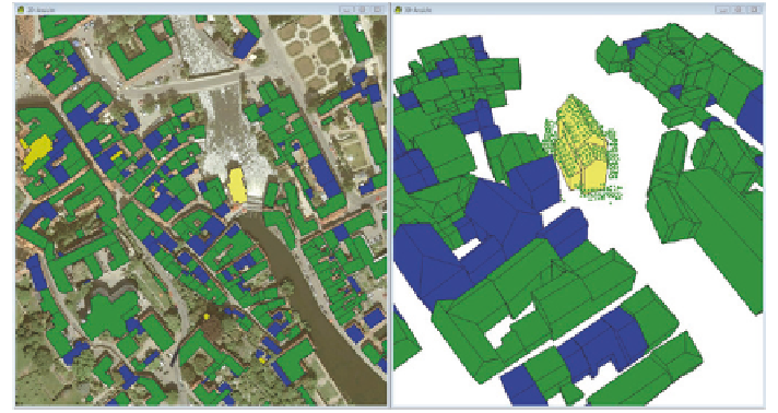
Fig. 5
DOP with building ground plans (
left
) and corresponding laser point cloud of a building
in
yellow
which needs to be edited (
right
)
surface normals (left) respectively the plot of laser points (right) placed over the
vector model.
2.2 Semiautomatic Realization of the First Acquisition
Since LiDAR-data are available Bavarian-wide but a state wide DSM from
Matching is not available, the 3D Building Model has to be derived from an exist-
ing laser point cloud. The technical realization of the previous described problem
of automated roof recognition has often been solved differently by existing soft-
ware packages of the shelf for the derivation of 3D Building Models.
The approach of the software “Building-Reconstruction” of Virtual City
SYSTEMS (VSC) runs firstly a planimetric fragmentation and then approxi-
mates the complete standard roof shape. The roof shape that fits best is applied.
Afterwards the roof surfaces of this roof shape are fitted systematically as good
as possible. In contrast to many other solutions, VCS meets Bavaria's required
planimetric constancy for buildings of the cadastre. With this it is ensured that
no additional data set besides the cadastre is built. In fact, the compliance of the
planimetric constancy offers the possibility to fully convert the cadastre to 3D in a
more simple form later on.
With the applied software the operator has 2 editing windows to his disposal.
In a 2D-view the digital orthophoto (DOP) is being overlaid with the planimetry
from the cadastre (Fig.
5
, left) and marked with color. Buildings with automatically
identified roofs which need no more post-editing are marked in blue. Painted in
green are the ones that were already post-edited by the operator. The yellow colored