Geoscience Reference
In-Depth Information
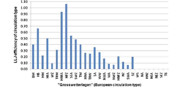
Fig. 3.17 Efficiency of Central European circulation types (Grosswetterlage) to produce a low-
level jet from two years of SODAR data
Such a high efficiency for forming a low-level jet allows for a quite certain
forecast of the occurrence of a low-level jet. Once such weather types are fore-
casted a low-level jet will form with a very high probability. The values given in
Fig.
3.17
can be used to give the low-level jet formation probability for Northern
Germany for each of the weather types. For other areas the investigation has to be
repeated with local low-level jet data.
3.4.2.3 Vertical Wind Profiles Below the Jet Core
The vertical wind profile during the occurrence of a low-level jet is modified from
(
3.16
). Empirically we suggest from SODAR measurements:
!
2
z
llj
z
p
z
llj
z
u
ð
z
Þ¼
u
log
ð
z
Þ
1
þ
Du
llj
ð
3
:
92
Þ
z
llj
z
p
where u
log
(z) is the equilibrium wind speed from (
3.16
), Du
llj
the relative speed-up
with reference to u
log
(z) in the centre of the low-level jet, z
llj
the height of the
centre of the low-level jet over ground and z
p
the height of the surface layer.
A low-level jet is related to a turning of the wind direction with height, d(z) as
well. Another empirical relation similar to (
3.92
) can be formulated:
z
llj
z
p
z
llj
z
d
ð
z
Þ¼
d
ð
z
p
Þþ
Dd
llj
ð
3
:
93
Þ
z
llj
z
p
where Dd
llj
is the absolute turning of wind direction from the top of the surface
layer to the core of the low-level jet in degrees. This turning may be illustrated
Search WWH ::

Custom Search