Geoscience Reference
In-Depth Information
rise, dramatically lowering the temperature of the after-
noon onshore breezes. The second area of cool ocean
(19 to 22°C) is located along the central southern coast
west of Lagos during the period July to October, for a
reason that is as yet unclear. From July to September, an
anomalously dry land area is located along the southern
coastal belt (see Figure 11.41) during what is termed the
little dry season. The reason is that at this time of year
the monsoon trough is in its most northerly position.
The coastal zone, lying 1200 to 1500 km to the south
of it and, more important, 400 to 500 km to the south of
its major rain belt, has relatively stable air (see Figure
11.40B), a condition assisted by the relatively cool
offshore coastal waters. Embedded within this relatively
cloudy but dry belt is the smaller Togo Gap, between 0°
and 3°E and having during the summer above-average
sunshine, subdued convection, relatively low rainfall
(i.e. less than 1000 mm) and low thunderstorm activity.
The trend of the coast here parallels the dominant
low-level southwesterly winds, so limiting surface
frictionally induced convergence in an area where
temperatures and convection are in any case inhibited by
low coastal water temperatures.
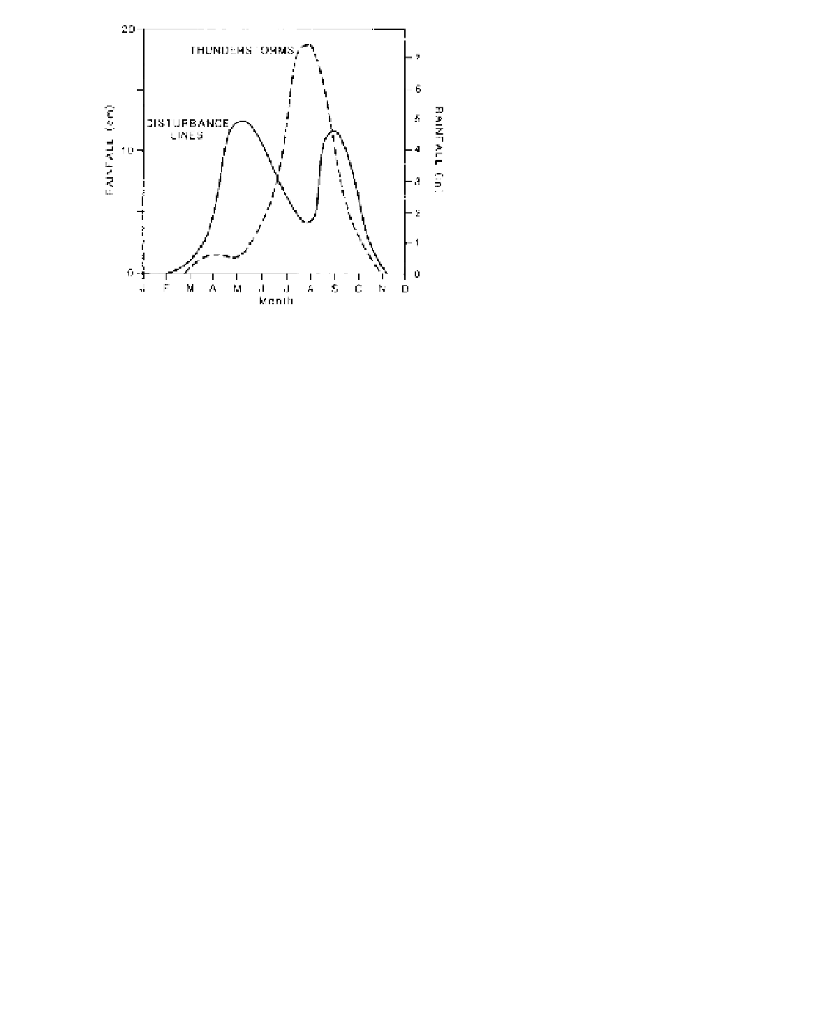
Figure 11.43
The contributions of disturbance lines and thun-
derstorms to the average monthly precipitation at Minna, Nigeria
(9.5°N).
Source
: After Omotosho (1985), by permission of the Royal
Meteorological Society.
Nigeria (4°N) contribute 28 per cent of the annual total
(about 2000 mm), thunderstorms 51 per cent and distur-
bance lines 21 per cent. At 10°N, 52 per cent of the total
(about 1000 mm) is due to disturbance lines, 40 per cent
to thunderstorms and only 9 per cent to the monsoon.
Over most of the country, rainfall from disturbance lines
has a double frequency maximum, thunderstorms a
single one in summer (see Figure 11.43 for Minna,
9.5°N). In the northern parts of Nigeria and Ghana, rain
falls in the summer months, mostly from isolated storms
or disturbance lines. The high variability of these rains
from year to year characterizes the drought-prone Sahel
environment.
The summer rainfall in the northern Soudana to
Sahelian belts is determined partly by the northward
penetration of the monsoon trough, which may range
up to 500 to 800 km beyond its average position (Figure
11.44), and by the strength of the easterly jet streams.
The latter affects the frequency of disturbance lines.
Anomalous climatic effects occur in a number
of distinct West African localities at different times of
the year. Although the temperatures of coastal waters
always exceed 26°C and may reach 29°C in January,
there are two areas of locally upwelling cold waters
(see Figure 11.41). One lies north of Conakry along
the coasts of Senegal and Mauretania, where dominant
offshore northeasterly winds in January to April skim
off the surface waters, causing cooler (20°C) water to
2 Southern Africa
Southern Africa lies between the South Atlantic and
Indian Ocean subtropical high-pressure cells in a region
subject to the interaction of tropical easterly and extra-
tropical westerly airflows. Both of these high-pressure
cells shift west and intensify (see Figure 7.10) in the
southern winter. Because the South Atlantic cell always
extends 3° latitude further north than the Indian Ocean
cell, it brings low-level westerlies to Angola and Zaire
at all seasons and high-level westerlies to central Angola
in the southern summer. The seasonal longitudinal shifts
of the subtropical high-pressure cells are especially
significant to the climate of southern Africa in respect
of the Indian Ocean cell. Whereas the 7 to 13° longi-
tudinal shift of the South Atlantic cell has relatively little
effect, the westward movement of 24 to 30° during
the southern winter by the Indian Ocean cell brings an
easterly flow at all levels to most of southern Africa.
The seasonal airflows and convergence zones are shown
in Figure 11.45.
In summer (i.e. January), low-level westerlies over
Angola and Zaire meet the northeast monsoon of East
Africa along the intertropical convergence zone (ITCZ),
which extends east as the boundary between the