Geoscience Reference
In-Depth Information
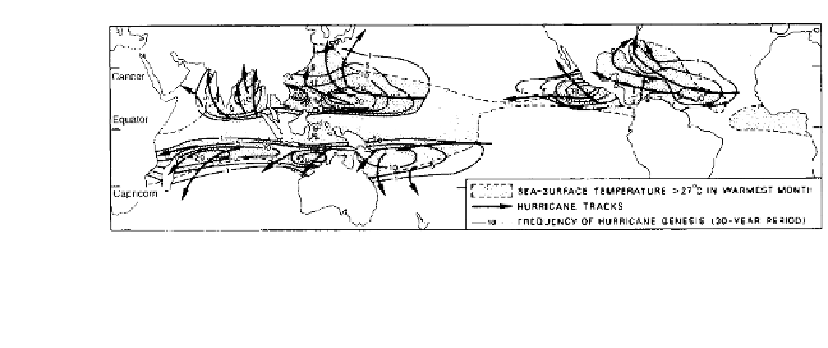
Figure 11.8
Frequency of hurricane genesis (numbered isopleths) for a twenty-year period. The principal hurricane tracks and the
areas of sea surface having water temperatures greater than 27°C in the warmest month are also shown.
Source
: After Palmén (1948) and Gray (1979).
and Indian Oceans, where the subtropical high-pressure
cells do not cause subsidence and stability and the upper
flow is divergent. About twice per season in the western
equatorial Pacific, tropical cyclones form almost simul-
taneously in each hemisphere near 5° latitude and along
the same longitude. The cloud and wind patterns in these
cyclone 'twins' are roughly symmetrical with respect
to the equator.
The role of convection cells in generating a massive
release of latent heat to provide energy for the storm
was proposed in early theories of hurricane develop-
ment. However, their scale was thought to be too small
for them to account for the growth of a storm hundreds
of kilometres in diameter. Research indicates that
energy can be transferred from the cumulus-scale to the
large-scale storm circulation through the organization
of the clouds into spiral bands (see Figure 11.9 and
Plate F), although the nature of the process is still being
investigated. There is ample evidence to show that
hurricanes form from pre-existing disturbances, but
while many of these disturbances develop as closed low-
pressure cells, few attain full hurricane intensity. The
key to this problem is high-level outflow (Figure 11.10).
This does not require an upper tropospheric anticyclone
but can occur on the eastern limb of an upper trough in
the westerlies. This outflow in turn allows the devel-
opment of very low pressure and high wind speeds
near the surface. A distinctive feature of the hurricane
is the warm vortex, since other tropical depressions
and incipient storms have a cold core area of shower
activity. The warm core develops through the action of
100 to 200 cumulonimbus towers releasing latent heat
of condensation; about 15 per cent of the area of cloud
bands is giving rain at any one time. Observations show
that although these 'hot towers' form less than 1 per cent
of the storm area within a radius of about 400 km, their
effect is sufficient to change the environment. The warm
core is vital to hurricane growth because it intensifies
the upper anticyclone, leading to a 'feedback' effect by
stimulating the low-level influx of heat and moisture,
which further intensifies convective activity, latent heat
release and therefore the upper-level high pressure. This
enhancement of a storm system by cumulus convection
is termed conditional instability of the second kind
(CISK) (cf. the basic parcel instability described on
p. 94). The thermally direct circulation converts the heat
increment into potential energy and a small fraction
of this - about 3 per cent - is transformed into kinetic
energy. The remainder is exported by the anticyclonic
circulation around the 12-km (200 mb) level.
In the eye, or innermost region of the storm (see
Figure 11.9 and Plate 28), adiabatic warming of
descending air accentuates the high temperatures,
although since high temperatures are also observed
in the eye-wall cloud masses, subsiding air can be only
one contributory factor. Without this sinking air in the
eye, the central pressure could not fall below about 1000
mb. The eye has a diameter of some 30 to 50 km, within
which the air is virtually calm and the cloud cover may
be broken. The mechanics of the eye's inception are
still largely unknown. If the rotating air conserved
absolute angular momentum, wind speeds would
become infinite at the centre, and clearly this is not the
case. The strong winds surrounding the eye are more
or less in cyclostrophic balance, with the small radial
distance providing a large centripetal acceleration (see