Geoscience Reference
In-Depth Information
c Precipitation and the moisture balance
Longitudinal influences are apparent in the distribution
of annual precipitation, although this is in large measure
a reflection of the topography. The 600-mm annual
isohyet in the United States approximately follows the
100°W meridian (Figure 10.19), and westward to the
Rockies is an extensive dry belt in the rain shadow of
the western mountain ranges. In the southeast, totals
exceed 1250 mm, and 1000 mm or more is received
along the Atlantic coast as far north as New Brunswick
and Newfoundland.
The major sources of moisture for precipitation over
North America are the Pacific Ocean and the Gulf of
Mexico. The former need not concern us here, since
comparatively little of the precipitation falling over the
interior appears to be derived from that source. The Gulf
source is extremely important in providing moisture for
precipitation over central and eastern North America,
but the predominance of southwesterly airflow means
that little precipitation falls over the western Great
Plains (see Figure 10.19). Over the southern United
States, there is considerable evapotranspiration and this
helps to maintain moderate annual totals northward and
eastward from the Gulf by providing additional water
vapour for the atmosphere. Along the east coast, the
Atlantic Ocean is an additional significant source of
moisture for winter precipitation.
There are at least eight major types of seasonal
precipitation regime in North America (Figure 10.20);
the winter maximum of the west coast and the transition
type of the intermontane region in mid-latitudes have
already been mentioned; the subtropical types are dis-
cussed in the next section. Four primarily mid-latitude
regimes are distinguished east of the Rocky Mountains:
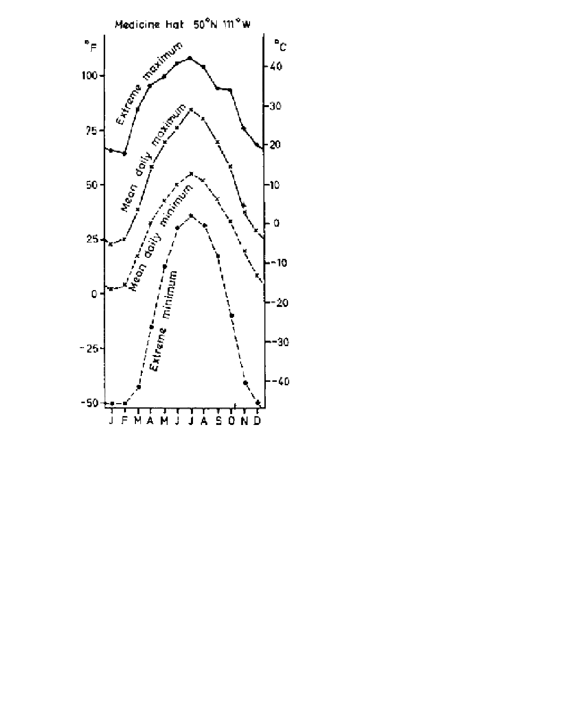
Figure 10.18
Mean and extreme temperatures at Medicine Hat,
Alberta.
Chinook conditions commonly develop in a Pacific
airstream that is replacing a winter high-pressure cell
over the western high plains. Sometimes the descending
chinook does not dislodge the cold, stagnant cP air of the
anticyclone and a marked inversion is formed. On other
occasions the boundary between the two airmasses
may reach ground level locally. Thus, for example, the
western suburbs of Calgary may record temperatures
above 0°C while those to the east of the city remain
below -15°C.
The weather impact of very cold and very hot spells
in the United States is costly, especially in terms of
loss of life. In the 1990s, there were 292 and 282 deaths
per year, respectively, attributed to extreme cold/hot
conditions, more than for any other severe weather.
1
A warm season maximum is found over much of the
continental interior (e.g. Rapid City). In an extensive
belt from New Mexico to the prairie provinces more
than 40 per cent of the annual precipitation falls in
summer. In New Mexico, the rain occurs mainly with
late summer thunderstorms, but May to June is the
wettest time over the central and northern Great
Plains due to more frequent cyclonic activity. Winters
are quite dry over the plains, but the mechanism of
the occasional heavy snowfalls is of interest. They
occur over the northwestern plains during easterly
upslope flow, usually in a ridge of high pressure.
Further north in Canada, the maximum is commonly