Geoscience Reference
In-Depth Information
has a frequency of 30 per cent or more over southeast
England in all months except March. The maximum
frequency of mP air at Kew (London) is 33 per cent
(with a further 10 per cent mPw) in July. The proportion
is even greater in western coastal districts, with mP and
mPw occurring in the Hebrides, for example, on at least
38 per cent of days throughout the year.
Airmass types can also be used to describe typical
weather conditions. Northwesterly mP airstreams
produce cool, showery weather at all seasons. The air is
unstable, forming cumulus clouds, although inland in
winter and at night the clouds disperse, giving low night
temperatures. Over the sea, heating of the lower air
continues by day and night in winter months, so showers
and squalls can occur at any time, and these affect
windward coastal areas. The average daily mean tem-
peratures with mP air are within about ±1°C of the
seasonal means in winter and summer, depending on
the precise track of the air. More extreme conditions
occur with mA air, the temperature departures at Kew
being approximately -4°C in summer and winter. The
visibility in mA air is usually very good. The contri-
bution of mP and mA air masses to the mean annual
rainfall over a five-year period at three stations in
northern England and North Wales is given in Table
10.2, although it should be noted that both airmasses may
also be involved in non-frontal polar lows. Over much of
southern England, and in areas to the lee of high ground,
northerly and northwesterly airstreams usually give clear
sunny weather with few showers. This is illustrated in
Table 10.2. At Rotherham, in the lee of the Pennines, the
percentage of the rainfall occurring with mP air is much
lower than on the West Coast (Squires Gate).
Maritime tropical air commonly forms the warm
sector of depressions moving from between west and
south towards Britain. The weather is unseasonably
mild and damp with mT air in winter. There is usually
a complete cover of stratus or stratocumulus cloud,
and drizzle or light rain may occur, especially over
high ground, where low cloud produces hill fog. The
clearance of cloud on nights with light winds readily
cools the moist air to its dew-point, forming mist and
fog. Table 10.2 shows that a high proportion of the
annual rainfall is associated with warm-front and warm-
sector situations and therefore is largely attributable to
convergence and frontal uplift within mT air. In summer
the cloud cover with this airmass keeps temperatures
closer to average than in winter; night temperatures tend
to be high, but daytime maxima remain rather low.
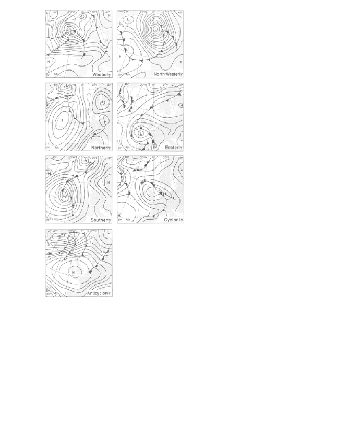
Figure 10.4
Synoptic situations over the British Isles classified
according to the primary airflow types of H.H. Lamb.
Source
: Lamb; O'Hare and Sweeney (1993). From
Geography
78(1).
Copyright © The Geographical Association and G. O'Hare.
Figure 10.5 illustrates the mean daily temperature in
central England and the mean daily precipitation over
England and Wales for each type in the mid-season
months for 1861 to 1979.
The monthly frequency of different airmass types
over Great Britain was analysed by J. Belasco for 1938
to 1949. There is a clear predominance of northwesterly
to westerly polar maritime (mP and mPw) air, which