Geoscience Reference
In-Depth Information
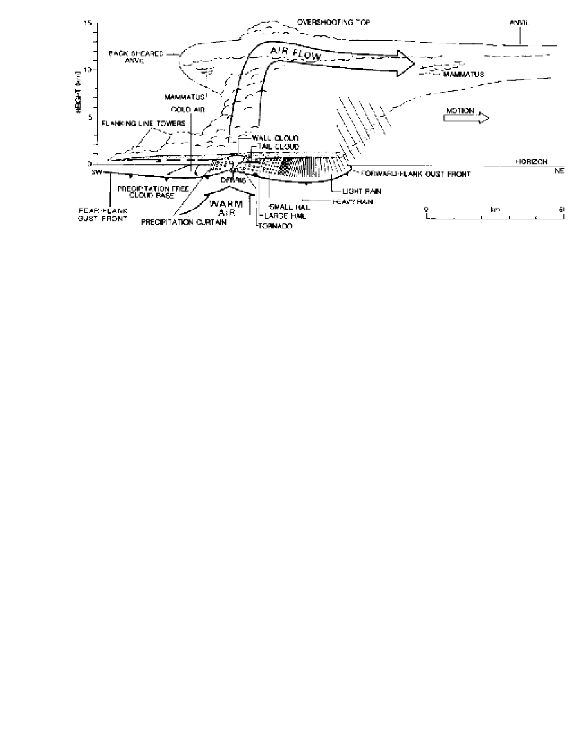
Figure 9.31
A super-cell thunderstorm.
Source
: After the National Severe Storms Laboratory, USA and H. Bluestein; from Houze and Hobbs (1982), copyright © Academic Press,
reproduced by permission.
the inversion. The convective trigger is sometimes
provided by the approach of a cold front towards the
western edge of the moist tongue. Tornadoes may also
occur in association with tropical cyclones (see p. 272)
and in other synoptic situations if the necessary vertical
contrast is present in the temperature, moisture and wind
fields.
The exact tornado mechanism is still not fully
understood because of the observational difficulties.
Tornadoes tend to develop in the right-rear quadrant of
a severe thunderstorm. Super-cell thunderstorms are
often identifiable in plan view on a radar reflectivity
display by a hook echo pattern on the right-rear flank.
The echo represents a (cyclonic or anticyclonic) spiral
cloud band about a small central eye and its appearance
may signal tornado development. The origin of the hook
echo appears to involve the horizontal advection of
precipitation from the rear of the mesocyclone. Rotation
develops where a thunderstorm updraft interacts with
the horizontal airflow. Provided that the wind speed
increases with height, the vertical wind shear generates
vorticity (Chapter 6B.3) about an axis normal to the
airflow, which is then tilted vertically by the updraft.
Directional shear also generates vorticity that the
updraft translates vertically. These two elements
lead to rotation in the updraft in the lower-middle
troposphere forming a meso-low, 10 to 20 km across.
Pressure in the meso-low is 2 to 5 mb lower than in the
surrounding environment. At low levels, horizontal
convergence increases the vorticity and rising air is
replenished by moist air from progressively lower levels
as the vortex descends and intensifies. The meso-low
shrinks in diameter and the conservation of momentum
increases the wind speed. At some point, a tornado,
sometimes with secondary vortices (Figure 9.34), forms
within the meso-low. The tornado funnel has been
observed to originate in the cloud base and extend
towards the surface (Plate 20). One idea is that con-
vergence beneath the base of cumulonimbus clouds,
aided by the interaction between cold precipitation
downdrafts and neighbouring updrafts, may initiate
the funnel. Other observations suggest that the funnel
forms simultaneously throughout a considerable depth
of cloud, usually a towering cumulus. The upper portion
of the tornado spire in this cloud may become linked
to the main updraft of a neighbouring cumulonimbus,
causing rapid removal of air from the spire and allowing
a sharp pressure decrease at the surface. The pressure
drop is estimated to exceed 200 to 250 mb in some cases,
and it is this that makes the funnel visible by causing air
entering the vortex to reach saturation. Over water,
tornadoes are termed waterspouts; the majority rarely
attain extreme intensities. The tornado vortex is usually
only a few hundred metres in diameter and in an even
more restricted band around the core the winds can
attain speeds of 50 to 100 ms
-1
. Intense tornadoes
may have multiple vortices rotating anticlockwise with
respect to the main tornado axis, each following a