Geoscience Reference
In-Depth Information
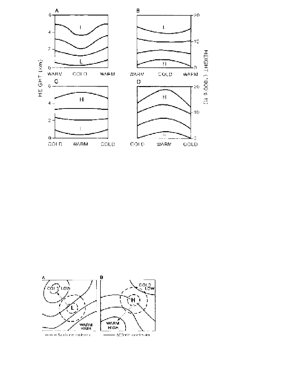
Figure 7.1
Models of the vertical
pressure distribution in cold and warm
air columns. (A) A surface low pres-
sure intensifies aloft in a cold air
column. (B) A surface high pressure
weakens aloft and may become a low
pressure in a cold air column. (C)
A surface low pressure weakens aloft
and may become a high pressure in a
warm air column. (D) A surface high
pressure intensifies aloft in a warm air
column.
causes the pressure surfaces to bulge upward, and
conversely a cold, more dense air column leads to
downward contraction of the pressure surfaces. Thus,
a surface high-pressure cell with a cold core (a
cold
anticyclone
), such as the Siberian winter anticyclone,
weakens with increasing elevation and is replaced
by low pressure aloft. Cold anticyclones are shallow
and rarely extend their influence above about 2500 m.
By contrast, a surface high with a warm core (a
warm
anticyclone
) intensifies with height (Figure 7.1D).
This is characteristic of the large subtropical cells,
which maintain their warmth through dynamic sub-
sidence. The warm low (Figure 7.1C) and cold high
(Figure 7.1B) are consistent with the vertical motion
schemes illustrated in Figure 6.7, whereas the other
two types are produced primarily by dynamic processes.
The high surface pressure in a warm anticyclone is
linked hydrostatically with cold, relatively dense air
in the lower stratosphere. Conversely, a cold depression
(Figure 7.1A) is associated with a warm lower strato-
sphere.
Mid-latitude low-pressure cells have cold air in the
rear, and hence the axis of low pressure slopes with
height towards the colder air to the west. High-pressure
cells slope towards the warmest air (Figure 7.2). Thus,
northern hemisphere subtropical high-pressure cells
are shifted 10 to 15° latitude southward at 3 km, and
towards the west. Even so, this slope of the high-
pressure axes is not constant through time.
2 Mean upper-air patterns
The patterns of pressure and wind in the middle
troposphere are less complicated in appearance than at
the surface as a result of the diminished effects of the
landmasses. Rather than using pressure maps at a partic-
ular height, it is convenient to depict the height of a
selected pressure surface; this is termed a
contour chart
by analogy with topographic relief map (see Note 1).
Figure 7.3 and 7.4 show that in the middle troposphere
of the southern hemisphere there is a vast circumpolar
Figure 7.2
The characteristic slope of the axes of low- and high-
pressure cells with height in the northern hemisphere.