Geoscience Reference
In-Depth Information
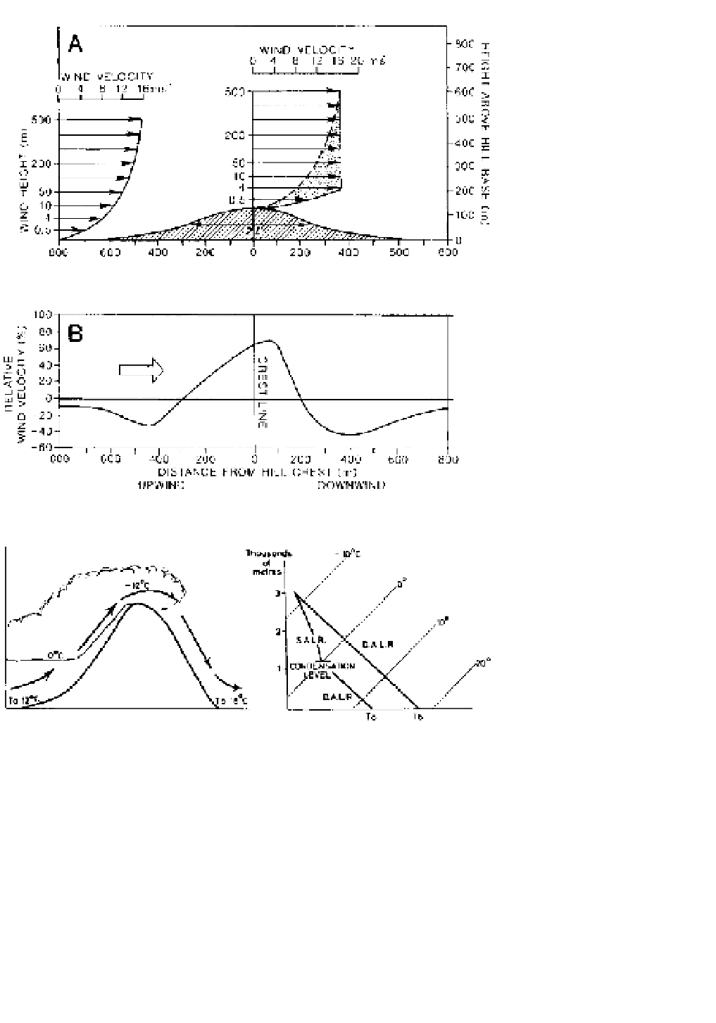
Figure 6.14
Airflow over Askervein
Hill, South Uist, off the west coast of
Scotland. (A) Vertical airflow profiles
(not true to scale) measured simul-
taneously 800 m upwind of the crest
line and at the crest line. L is the
characteristic length
of the obstruction
(i.e. one-half the hill width at mid-
elevation, here 500 m) and is also the
height above ground level to which
the flow is increased by the topo-
graphic obstruction (shaded). The
maximum speed-up of the airflow due
to vertical convergence over the crest
is to about 16.5 m s
-1
at a height of
4 m. (B) The relative speed-up (per
cent) of airflow upwind and down-
wind of the crest line measured 14 m
above ground level.
Source
: After Taylor, Teunissen and
Salmon
et al
. From Troen and Petersen
(1989).
Figure 6.15
The föhn effect when an
air parcel is forced to cross a mountain
range.
T
a
refers to the temperature at
the windward foot of the range and
T
b
to that at the leeward foot.
and spring, when the accompanying rapid temperature
rise may help to trigger avalanches on the snow-covered
slopes. At Tashkent in Central Asia, where the mean
winter temperature is about freezing point, temperatures
may rise to more than 21°C during a föhn. In the same
way, the chinook is a significant feature at the eastern
foot of the New Zealand Alps, the Andes in Argentina,
and the Rocky Mountains. At Pincher Creek, Alberta, a
temperature rise of 21°C occurred in four minutes with
the onset of a chinook on 6 January 1966. Less spec-
tacular effects are also noticeable in the lee of the Welsh
mountains, the Pennines and the Grampians in Great
Britain, where the importance of föhn winds lies mainly
in the dispersal of cloud by the subsiding dry air. This
is an important component of so-called 'rain shadow'
effects.
In some parts of the world, winds descending on
the lee slope of a mountain range are cold. The type
example of such 'fall-winds' is the bora of the northern
Adriatic, although similar winds occur on the northern
Black Sea coast, in northern Scandinavia, in Novaya
Zemlya and in Japan. These winds occur when cold
continental airmasses are forced across a mountain
range by the pressure gradient and, despite adiabatic
warming, displace warmer air. They are therefore
primarily a winter phenomenon.