Geoscience Reference
In-Depth Information
less dense air. The maximum velocity occurs just before
sunrise at the time of maximum diurnal cooling. As with
the valley wind, an upper return current, in this case
up-valley, also overlays the mountain wind.
Katabatic drainage is usually cited as the cause of
frost pockets in hilly and mountainous areas. It is argued
that greater radiational cooling on the slopes, especially
if they are snow-covered, leads to a gravity flow of
cold, dense air into the valley bottoms. Observations
in California and elsewhere, however, suggest that
the valley air remains colder than the slope air from the
onset of nocturnal cooling, so that the air moving down-
slope slides over the denser air in the valley bottom.
Moderate drainage winds will also act to raise the valley
temperatures through turbulent mixing. Cold air pockets
in valley bottoms and hollows probably result from
the cessation of turbulent heat transfer to the surface in
sheltered locations rather than by cold air drainage,
which is often not present.
and humidity on the coast of California. A basic offshore
gradient flow is perturbed during the day by a westerly
sea breeze. Initially, the temperature difference between
the sea and the coastal mountains of central California
sets up a shallow sea breeze, which by midday is 300 m
deep. In the early afternoon, a deeper regional-scale
circulation between the ocean and the hot interior
valleys generates a 1-km deep onshore flow that persists
until two to four hours after sunset. Both the shallow
and the deeper breeze have maximum speeds of 6 m s
-1
.
A shallow evening land breeze develops by 1900 PST
but is indistinguishable from the gradient offshore flow.
The advancing cool sea air may form a distinct line
(or
front
, see Chapter 9D) marked by cumulus cloud
development, behind which there is a distinct wind
velocity maximum. This often develops in summer, for
example, along the Gulf Coast of Texas. On a smaller
scale, such features are observed in Britain, particularly
along the south and east coasts. The sea breeze has
a depth of about 1km, although it thins towards the
advancing edge. It may penetrate 50 km or more inland
by 21:00 hours. Typical wind speeds in such sea breezes
are 4 to 7 ms
-1
, although these may be greatly increased
where a well-marked low-level temperature inversion
produces a 'Venturi effect' by constricting and accel-
erating the flow. The much shallower land breezes are
usually weaker, about 2 m s
-1
. Counter-currents aloft
are generally weak and may be obscured by the regional
airflow, but studies on the Oregon coast suggest that
under certain conditions this upper return flow may be
related very closely to the lower sea breeze conditions,
even to the extent of mirroring the surges in the latter.
In mid-latitudes the Coriolis deflection causes turning of
a well-developed onshore sea breeze (clockwise in the
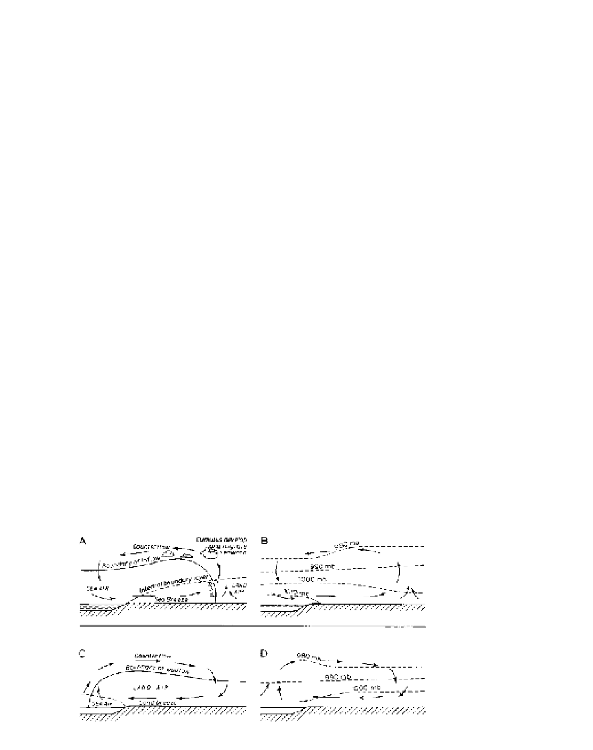
2 Land and sea breezes
Another thermally induced wind regime is the land
and sea breeze (see Figure 6.11). The vertical expansion
of the air column that occurs during daytime heating
over the more rapidly heated land (see Chapter 3B.5)
tilts the isobaric surfaces downward at the coast, causing
onshore winds at the surface and a compensating
offshore movement aloft. Typical land-sea pressure
differences are of the order of 2 mb. At night, the air
over the sea is warmer and the situation is reversed,
although this reversal is also the effect of down-slope
winds blowing off the land. Figure 6.12 shows that
sea breezes can have a decisive effect on temperature
Figure 6.11
Diurnal land and sea
breezes. (A) and (B) Sea breeze circu-
lation and pressure distribution in the
early afternoon during anticyclonic
weather. (C) and (D) Land breeze
circulation and pressure distribution at
night during anticyclonic weather.
Source
: (A) and (C) after Oke (1978).