Geoscience Reference
In-Depth Information
the funnel-shaped lowland to the south, results
in some of the heaviest annual rainfall totals
recorded anywhere. Mawsyuran (1400m eleva-
tion), 16km west of the more famous station of
Cherrapunji, has a mean annual total (1941-1969)
of 12,210mm and can claim to be the wettest
spot in the world. Cherrapunji (1340m) during
the same period averaged 11,020mm; extremes
recorded there include 5690mm in July and
24,400mm in 1974 (see
Figure 4.11
). However,
throughout the monsoon area, topography plays
a secondary role in determining rainfall distribu-
tion to the synoptic activity and large-scale
dynamics.
Really high relief produces major changes in
the main weather characteristics and is best treated
as a special climatic type. In equatorial East Africa,
the three volcanic peaks of Mount Kilimanjaro
(5800m), Mount Kenya (5200m) and Ruwenzori
(5200m) nourish permanent glaciers above
4700-5100m. Annual precipitation on the summit
of Mount Kenya is about 1140mm, similar to
amounts on the plateau to the south, but on the
southern slopes between 2100 and 3000m, and
on the eastern slopes between about 1400 and
2400m, totals exceed 2500mm. Kabete (at an
elevation of 1,800m near Nairobi) exhibits many
of the features of tropical highland climates,
having a small annual temperature range (mean
monthly temperatures are 19°C for February and
16
and subsiding around 20:00. It may be up to
1000-2000m in height, with a maximum velocity
at an elevation of 200-400m, and it normally
penetrates some 20-60km inland.
On large islands under calm conditions the sea
breezes converge towards the center so that an
afternoon maximum of rainfall is observed. Under
steady Trade Winds, the pattern is displaced
downwind so that descending air may be located
over the center of the island. A typical case of an
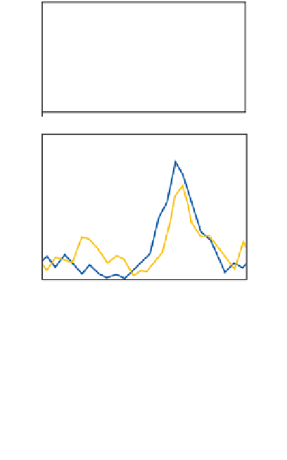
afternoon maximum is illustrated in
Figure 11.57B
for Nandi (Viti Levu, Fiji) in the southwest Pacific.
The station has a lee exposure in both wet and dry
seasons. This rainfall pattern is commonly believed
to be widespread in the tropics, but over the open
sea and on small islands a night-time maximum
(often with a peak near dawn) seems to occur, and
even large islands may display this nocturnal
regime when there is little synoptic activity.
Figure
11.57A
illustrates this nocturnal pattern at four
7.0
WESTERN PACIFIC
(A)
175
Large
Islands
6.0
150
5.0
Small
Islands
125
4.0
100
75
3.0
0
0
04
08
12
16
20
24
8
NANDI 18°S 178°E
(B)
C for July), a high diurnal temperature range
(averaging 9.5°C in July and 13°C in February)
and a large average cloud cover (mean 7-8/10ths).
°
6
Wet Season
4
2
Dry Season
3 Diurnal variations
Diurnal weather variations are particularly evident
at coastal locations in the Trade Wind belt and in
the Indonesia-Malaysian Archipelago. Land- and
sea-breeze regimes (see Chapter 6C.1) are well
developed, as the heating of tropical air over land
can be up to five times that over adjacent water
surfaces. The sea breeze normally sets in between
08:00 and 11:00 hours, reaching a maximum
velocity of 6-15m s
-1
0
-2
00
04
08
12
Local time (hr)
16
20
24
Figure 11.57
Diurnal variation of rainfall intensity
for tropical islands in the Pacific. A: Large and
small islands in the western Pacific. B: Wet and
dry seasons for Nandi (Fiji) in the south-west
Pacific (percentage deviation from the daily average).
Sources: A: After Gray and Jacobson (1977). B: After
Finkelstein in Hutchings (1964).
at about 13:00 to 16:00