Geoscience Reference
In-Depth Information
(A)
30°N
Sahel
N
DRY
20°
D
MT
MT
N
10°
Cloudy: prolonged rain
0
1000
S
km
(B)
E
16
N
S
100
14
12
200
10
300
8
400
6
500
4
600
700
2
800
0
25°N
20°
15°
10°
5°
DRY
ISOLATED
STORMS
DISTURBANCE
LINES
CLOUDY:
PROLONGED
RAIN
CLOUDY:
LIGHT RAIN
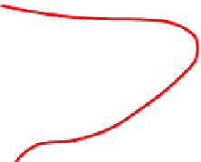
Figure 11.40
The structure of the circulation over North Africa in August. A: Surface airflow and easterly tropical
jet. B: Vertical structure and resulting precipitation zones over West Africa. MT = Monsoon Trough. Note there is
thunderstorm activity associated with the cumulonimbus towers.
Sources: A: Reproduction from the Geographical magazine, London. B: From Maley (1982) Quaternary Research. Copyright © Academic
Press; reproduced by permission. Musk (1983). By permission of the Geographical magazine.
With the approach of the northern summer,
the strengthening of the South Atlantic sub-
tropical high pressure cell, combined with the
increased continental temperatures, establishes a
strong southwesterly airflow at the surface that
spreads northward behind the Monsoon Trough,
lagging about six weeks behind the progress of
the overhead sun. The northward migration of the