Geoscience Reference
In-Depth Information
60°
70°
80°
90°
100°
110°
120°
130°
140°E
40°N
40°N
30°
30°
Tibetan Plateau
20°
20°
10°
10°
0°
0
1000
0°
km
80°
90°
100°
110°
120°
130°
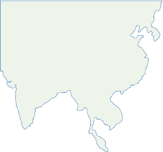
Figure 11.34
Mean onset date of the winter monsoon (i.e., retreat of the summer monsoon) over South
and East Asia.
Sources: After Tao Shi-yan and Chen Longxun. Reproduced by permission of Professor Tao Shi-yan and the Chinese Geographical
Society.
the major season for Bay of Bengal cyclones and
it is these disturbances, rather than the onshore
northeasterly monsoon, that cause the October/
November maximum of rainfall in southeast India
(e.g., Madras:
Figure 11.20
).
During October, the westerly jet re-establishes
itself south of the Tibetan Plateau, often within a
few days, and cool season conditions are restored
over most of South and East Asia.
winter monsoon (reinforced by subsiding air from
the upper westerlies) persists in north China, and
even in the south it begins to be replaced by
maritime tropical air only in April to May. Thus,
at Guangzhou (Canton), mean temperatures
rise from only 17
°
C in March to 27
°
C in May,
some 6
C lower than the mean values over
northern India.
The rains in western China begin earlier in the
northwest in mid-May and then extend south-
ward and eastward until mid-June. Also during
this season upper-level cold lows forming east
of Lake Baikal affect northeastern China,
contributing 20-60 percent of the warm season
rainfall and over half of the hailstorms. Westerly
depressions are most frequent over China in
°
D EAST ASIAN AND
AUSTRALIAN SUMMER
MONSOONS
China has no equivalent to India's hot, pre-
monsoon season. The low-level, northeasterly