Geoscience Reference
In-Depth Information
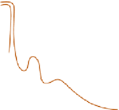
A key part of the southwest monsoonal flow
occurs in the form of a 15-45m s
-1
jet stream at a
level of only 1000-1500m. This jet, strongest
during active periods of the Indian monsoon,
flows northwestwards from Madagascar (
Figure
11.31
) and crosses the equator from the south
over East Africa, where its core is often marked by
a streak of cloud and where it may bring excessive
local rainfall. The jet is displaced northward and
strengthens from February to July; by May it
has become constricted against the Ethiopian
Highlands, it accelerates still more and is deflected
eastward across the Arabian Sea towards the west
coast of the Indian peninsula. This low-level jet,
unique in the Trade Wind belt, flows offshore
from the Horn of Africa, bringing up cool waters
and contributing to a temperature inversion that
is also produced by dry upper air originating over
Arabia or East Africa and by subsidence due to the
convergent upper easterlies. The flow from the
southwest over the Indian Ocean is relatively dry
near the equator and near shore, apart from a
shallow, moist layer near the base. Downwind
towards India, however, there is a strong tempera-
ture and moisture interaction between the ocean
surface and the low-level jet flow. Hence, deep
convection builds up and convective instability is
released, especially as the airflow slows down and
converges near the west coast of India and as it is
forced up over the Western Ghats. A portion of this
southwest monsoon airflow is deflected by the
Western Ghats to form 100km diameter offshore
vortices lasting two to three days and capable of
bringing 100mm of rain in 24 hours along the
western coastal belt of the peninsula. At Mangalore
(13°N), there are on average 25 rain days per
month in June, 28 in July and 25 in August. The
monthly rainfall averages are 980, 1060 and
580mm, respectively, accounting for 75 percent of
the annual total. In the lee of the Ghats, amounts
are much reduced and there are semi-arid areas
receiving less than 640mm per year.
In southern India, excluding the southeast,
there is a marked tendency for less rainfall when
40°
60°
80°E
40°
60°
80°E
20°N
20°N
AP
RIL
0°
0°
20°S
20°S
(A)
(B)
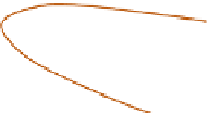
Figure 11.31
The mean monthly positions (A) and the mean July velocity (m s
-1
) (B) of the low-level (1km) Somali
jet stream over the Indian Ocean.
Source: After Findlater (1971). Reproduced by permission of the Controller of Her Majesty's Stationery Office.