Geoscience Reference
In-Depth Information
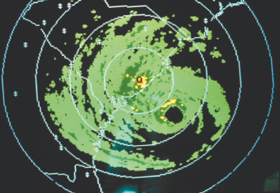
Plate 11.2
Radar image of Hurricane Hugo as observed by the South Carolina Weather Service Office, Charleston,
SC on 21 September 1989. At landfall, winds were 85mph (max 160mph) in South Carolina. A storm surge coupled
with high tide caused losses of $1 billion through damage to homes and timber, especially in North Carolina, with
seven deaths and dozens of injuries.
Source:NOAA Central Library fly 00232.
intensity classes are distinguished: category 1,
weak (winds of 33-42m s
-1
); 2, moderate (43-49m
s
-1
); 3, strong (50-58m s
-1
); 4, very strong
(59-69m s
-1
) and 5, devastating (70m s
-1
or
more). Hurricane Camille, which struck coastal
Mississippi in August 1969, was a category 5
storm, while Hurricane Andrew, which devastated
southern Florida in August 1992, has been
reclassified also as a category 5 storm. Hurricane
Katrina in August 2005 was the second category
five storm of that season and the most destructive
to date (see
p. 301
).
In 1997, there were 11 super-typhoons in the
northwest Pacific with winds > 66m s
-1
. The great
vertical development of cumulonimbus clouds,
with tops at over 12,000m, reflects the immense
convective activity concentrated in such systems.
Radar and satellite studies show that the convec-
tive cells are normally organized in bands that
spiral inward towards the center.
Although the largest cyclones are characteristic
of the Pacific, the record is held by the Caribbean
hurricane 'Gilbert'. It was generated 320km east
of Barbados on 9 September 1988 and moved
westward at an average speed of 24-27km hr
-1
,
dissipating off the east coast of Mexico. Aided by
an upper tropospheric high pressure cell north of
Cuba, Hurricane Gilbert intensified very rapidly,
the pressure at its center dropped to 888mb (the
lowest ever recorded in the Western Hemisphere),