Geoscience Reference
In-Depth Information
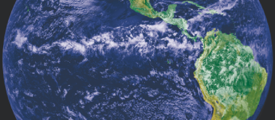
Plate 11.1
The ITCZ appears as a band of bright white clouds that cuts across the center of the image; this is a
combination of cloud data from NOAA's GOES-11 and land cover classification data.
Source: GOES Project Science Office.
essentially competitive between different regions
potentially available to form part of a continuous
ITCZ. The convective rainfall belt of the ITCZ
has very sharply defined latitudinal limits. For
example, along the West African coast the
following mean annual rainfalls are recorded:
heating needed to maintain the low pressure
trough. In fact, this does not happen. Solar energy
is available to heat the surface because the
maximum surface wind convergence, uplift and
cloud cover is commonly located several degrees
equatorward of the trough. In the Atlantic (
Figure
11.2B
), for example, the cloudiness maximum is
distinct from the Equatorial Trough in August.
Figure 11.2
illustrates regional differences in the
Equatorial Trough and ITCZ. Convergence of two
Trade Wind systems occurs over the central North
Atlantic in August and the eastern North Pacific
in February. In contrast, the Equatorial Trough
is defined by easterlies on its poleward side
and westerlies on its equatorward side over West
Africa in August and over New Guinea in February.
The dynamics of low-latitude atmosphere-
ocean circulations are also involved. The
Convergence Zone in the central equatorial Pacific
moves seasonally between about 4°N in March to
April and 8
12
°
N
1939mm
15°N
542mm
18
°
N
123mm
In other words, moving southwards into the
ITCZ, precipitation increases by 440 percent in a
meridional distance of only 330km.
As climatic features, the Equatorial Trough and
the ITCZ are asymmetric around the equator,
lying on average to the north. They also move
seasonally away from the equator (see
Figure 11.1
)
in association with the thermal equator (zone of
seasonal maximum temperature). The location of
the thermal equator is directly related to solar
heating (see
Figures 11.2
and
3.11
), and there is an
obvious link between this and the Equatorial
Trough in terms of thermal lows. However, if the
ITC were to coincide with the Equatorial Trough
then this zone of cloudiness would decrease
incoming solar radiation, reducing the surface
N in September, giving a single
pronounced rainfall maximum in March to April.
This appears to be a response to the relative
strengths of the northeast and southeast trades.
The ratio of South Pacific/North Pacific Trade
Wind strength exceeds 2 in September but falls to
°