Geoscience Reference
In-Depth Information
1020
160°
140°
120°
100°
80°
60°
1015
1000
L
L
1000
L
L
L
H
1000
1005
1010
L
H
H
H
H
L
100°
80
°
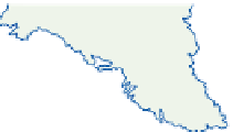
Warm front
Cold front
Quasi-stationary front
Trowal
Figure 10.14
A synoptic example of depressions associated with three frontal zones on 29 May 1963
over North America.
Source: Based on charts of the Edmonton Analysis Office and the Daily Weather Report.
summer rains (see B.3, this chapter). Bryson
and Lahey (1958) suggest that these circulation
changes at the end of June may be connected with
the disappearance of snow cover from the arctic
tundra. This leads to a sudden decrease of surface
albedo from about 75 to 15 percent, with conse-
quent changes in the heat budget components and
hence in the atmospheric circulation.
Frontal wave activity makes the first half of
September a rainy period in the northern Midwest
states of Iowa, Minnesota and Wisconsin, but after
about 20 September, anticyclonic conditions
return with warm airflow from the dry southwest,
giving fine weather - the so-called Indian summer.
Significantly, the hemispheric zonal index value
rises in late September. This anticyclonic weather
type has a second phase in the latter half of
October, but at this time there are polar outbreaks.
The weather is generally cold and dry, although if
precipitation does occur there is a high probability
of snowfall.
2 The temperate west coast and
cordillera
The oceanic circulation of the North Pacific
closely resembles that of the North Atlantic. The
drift from the Kuroshio Current off Japan is
propelled by the westerlies towards the west coast
of North America and it acts as a warm current
between 40
N. Sea surface temperatures
are several degrees lower than in comparable
latitudes off Western Europe, however, due to
the smaller volume of warm water involved. In
addition, in contrast to the Norwegian Sea,
the shape of the Alaskan coastline prevents the
°
and 60
°