Geoscience Reference
In-Depth Information
60°
40°
20°
0°
20°
40°
60°
80°
25
12.5
70°
50
60°
12.5
100
12.5
100
25
60°
50
50°
25
50
50°
50
25
50
40°
50
12.5
25
100
25
100
150
40°
25
30°
12.5
100
20°
10°
0°
10°
20°
30°
40°
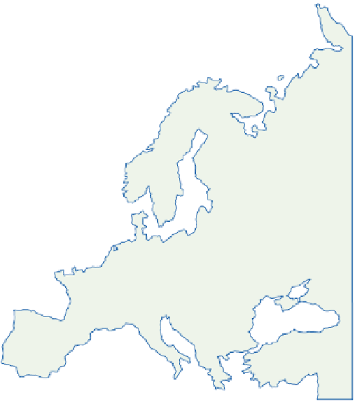
Figure 10.10
The mean precipitation anomaly, as a percentage of the average, during anticyclonic
blocking in winter over Scandinavia. Areas above normal are cross-hatched, areas recording precipitation
between 50 and 100 percent of normal have oblique hatching.
Source: After Rex (1950). By permission of Tellus.
produces a sharp decrease in the amounts. The
upper Gudbrandsdalen and Osterdalen in the lee
of the Jotunheim and Dovre Mountains receive an
average of less than 500mm, and similar low
values are recorded in central Sweden around
Östersund.
Mountains can function equally in the
opposite sense. For example, Arctic air from the
Barents Sea may move southward in winter over
the Gulf of Bothnia, usually when there is a
depression over northern Russia, giving very low
temperatures in Sweden and Finland. Western
Norway is rarely affected, since the cold wave is
contained to the east of the mountains. In
consequence, there is a sharp climatic gradient
across the Scandinavian highlands in the winter
months.
The Alps illustrates other topographic effects.
Together with the Pyrenees and the mountains
of the Balkans, the Alps effectively separate the
Mediterranean climatic region from that of
Europe. The penetration of warm air masses north
of these barriers is comparatively rare and short-
lived. However, with certain pressure patterns, air
from the Mediterranean and northern Italy is
forced to cross the Alps, losing its moisture
through precipitation on the southern slopes. Dry
adiabatic warming on the northern side of the
mountains can readily raise temperatures by 5-6
C
in the upper valleys of the Aar, Rhine and Inn. At
°