Geoscience Reference
In-Depth Information
(A)
JANUARY
APRIL
JULY
SEPTEMBER
20
20
20
20
S
Q4
/Q
5
S
15
15
15
15
Q4
/Q
5
Q1/Q2
Q1/Q2
S
Q4
/Q
5
10
10
10
10
Q1/Q2
Q4
/Q
5
5
S
5
5
5
Q1/Q2
0
0
0
0
(B)
12
12
12
12
10
10
10
10
8
8
8
C
8
C
C
6
6
6
6
C
4
4
4
4
T
2/T
3
T1/T2
T2
/T
3
T1/T2
T2
/T
3
T1/T2
T2
/T
3
T1/T2
S
2
S
2
2
2
S
S
0
0
0
0
(C)
40
40
40
40
30
30
30
30
20
20
20
20
10
10
10
10
0
0
0
0
NNE
E
SE SSW
W NW NAC
NNE
E
SE SSW
WNWN A C
Circulation types
NNE
E
SE SSW
WNW N A C
NNE
E
SE S SW
WNWN A C
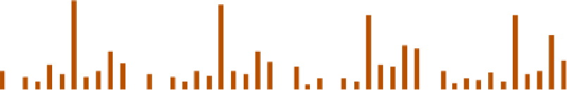
Figure 10.5
Average climatic conditions associated with Lamb's circulation types for January, April, July and
September, 1861-1979. Top: Mean daily temperature (°C) in central England for the straight (S) airflow types; at the
right side are the quintiles of mean monthly temperature (i.e., Q1/Q2 = 20 percent, Q4/Q5 = 80 percent). Middle:
Mean daily rainfall (in millimeters) over England and Wales for the straight (S) and cyclonic (C) subdivisions of each
type and terciles of the mean values (i.e., T1/T2 = 33 percent, T2/T3 = 67 percent). Bottom: Mean frequency (percent)
for each circulation type, including anticyclonic (A) and cyclonic (C).
Source: After Storey (1982) By permission of the Royal Meteorological Society.
Table 10.2
Percentage of the annual rainfall (1956-1960) occurring with different synoptic situations
Station
Synoptic categories
Warm
Warm
Cold
Occlusion
Polar
mP
cP
Arctic
Thunder-
front
sector
front
low
storm
Cwm Dyli (99m)*
18
30
13
10
5
22
0.1
0.8
0.8
Squires Gate (10m)†
23
16
14
15
7
22
0.2
0.7
3
Rotherham (21m)‡
26
9
11
20
14
15
1.5
1.1
3
Source: After Shaw (1962), and R. P. Mathews (unpublished).
Notes: *Snowdonia. †On the Lancashire coast (Blackpool). ‡In the Don Valley, Yorkshire.
cloud on nights with light winds readily cools the
moist air to its dew-point, forming mist and fog.
Table 10.2
shows that a large proportion of the
annual rainfall is associated with warm-front and
warm-sector situations and therefore is largely
attributable to convergence and frontal uplift
within mT air. In summer the cloud cover with
this air mass keeps temperatures closer to average
than in winter; night temperatures tend to be high,
but daytime maxima remain rather low.
In summer, 'plumes' of warm, moist mT air
may spread northward from the vicinity of
Spain into Western Europe. This air is very
unstable, with a significant vertical wind shear