Geoscience Reference
In-Depth Information
precipitation over Colorado in spring and autumn
is often associated with cold lows.
The squall line often occurs ahead of a cold front,
maintained either as a self-propagating distur-
bance or by thunderstorm downdrafts. It may
form a pseudo-cold front between rain-cooled air
and a rainless zone within the same air mass. Mid-
latitude squall lines appear to form through one
of two mechanisms: (1) a pressure jump that
propagates as a bore; (2) the leading edge of a cold
front aloft (CFA) acting on instability present to
the east of an orographic lee trough. In frontal
cyclones, cold air in the rear of the depression
may overrun air in the warm sector. The intrusion
of this nose of cold air sets up great instability, and
the subsiding cold wedge tends to act as a scoop
forcing up the slower moving warm air.
Figure 9.28
demonstrates that the
relative
motion of the warm air is towards the squall line.
Such conditions generate severe frontal thunder-
storms such as that which struck Wokingham,
England, in September 1959. This moved from the
southwest at about 20m s
-1
, steered by strong
southwesterly flow aloft. The cold air subsided
from high levels as a violent squall, and the updraft
ahead of this produced an intense hailstorm.
Hailstones grow by accretion in the upper part of
the updraft, where speeds in excess of 50m s
-1
are
not uncommon, are blown ahead of the storm by
strong upper winds, and begin to fall. This causes
surface melting, but the stone is caught up again
by the advancing squall line and reascends. The
melted surface freezes, giving glazed ice as the
stone is carried above the freezing level, and
further growth occurs through the collection of
supercooled droplets (see also Chapter 4, pp. 124
and 140).
Various types of MCS occur over the central
United States in spring and summer (see
Figure
9.29
), bringing widespread severe weather. They
may be small convective cells organized linearly,
or as a large amorphous cell known as a
mesoscale
convective complex
(MCC). This develops from
initially isolated cumulonimbus cells. As rain
falls from the thunderstorm clouds, evaporative
cooling of the air beneath the cloud bases sets
up cold downdrafts, and when these become
I MESOSCALE CONVECTIVE
SYSTEMS
Mesoscale convective systems (MCSs) are
intermediate in size and lifespan between synoptic
disturbances and individual cumulonimbus
cells (see
Figure 9.26
).
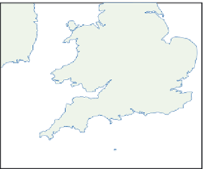
Figure 9.27
shows the
movement of clusters of convective cells, each cell
about 1km in diameter, as they crossed southern
Britain with a cold front. Each individual cell may
be short-lived, but cell clusters may persist for
hours, strengthening or weakening due to
orographic and other factors.
MCSs occur seasonally in mid-latitudes (parti-
cularly the central United States, eastern China and
South Africa) and the tropics (India, West and
Central Africa and northern Australia) as either
nearly circular clusters of convective cells or linear
squall lines. The
squall line
consists of a narrow line
of thunderstorm cells, which may extend for
hundreds of kilometers. It is marked by a sharp
veer in wind direction and very gusty conditions.
0
100
km
23.45
21.45
19.45
17.45
15.45
Figure 9.27
Successive positions of individual
clusters of mid-tropospheric convective cells
moving across southern Britain at about 50km hr
-1
with a cold front. Cell location and intensity were
determined by radar.
Source: After Browning (1990). By permission of the Royal
Meteorological Society.