Geoscience Reference
In-Depth Information
(A)
(B)
6km
Y
40cm/s up
Descending
dry air
with
low θ
w
Cold-front zone
Line convection
3km
5m/s up
Warm
conveyor
belt
20cm/s down
Low-
level
jet
X
Y
X
Surface cold front
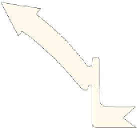
Figure 9.15
Schematic diagrams showing airflows, relative to the moving frontal system, at an ana-cold front. A
warm conveyor belt (stippled) ascends above the front with cold air (dashed arrows) descending beneath it. A: Plan
view. B: Vertical section along the line X-Y, showing rates of vertical motion.
Source: Browning (1990). By permission of the American Meteorological Society.
occlusion,
where the warm sector air is lifted off the
ground
.
Occlusions are classified as either
cold
or
warm
, depending on the relative states of the air
masses lying in front and to the rear of the warm
sector (
Figure 9.16
). If air mass 2 is colder than air
mass 1, then the occlusion is warm, but if the
reverse is so it is termed a cold occlusion. The air
in advance of the depression is likely to be coldest
when depressions occlude over Europe in winter
and very cold cP air is affecting the continent.
Recent work suggests that most occlusions are
warm and that the thermal definition is often
misleading. A new definition is proposed: a cold
(warm) occlusion forms when the air that is more
statically stable lies behind the cold front (ahead
of the warm front) (
Figure 9.16
).
The line of the warm air wedge aloft is
associated with a zone of layered cloud (similar
to that found with a warm front) and often of
precipitation. Hence its position is indicated
separately on some weather maps and it is referred
to by Canadian meteorologists as a
trowal
(trough
of warm air aloft). The passage of an occluded
front and trowal brings a change back to polar air-
mass weather.
A different process occurs when there is
interaction between the cloud bands within a
polar trough and the main polar front, giving rise
to an
instant occlusion
. A warm conveyor belt on
the polar front ascends as an upper tropospheric
jet, forming a stratiform cloud band (
Figure 9.17
),
while a low-level polar trough conveyor belt at
right angles to it produces a convective cloud band
and precipitation area poleward of the main polar
front on the leading edge of the cold pool.
Frontolysis
(frontal decay) represents the final
phase of a front's existence although it is not
necessarily linked with occlusion. Decay occurs
when differences no longer exist between adjacent
air masses. This may arise in four ways: (1)
through their mutual stagnation over a similar
surface; (2) as a result of both air masses moving
on parallel tracks at the same speed; (3) through
their movement in succession along the same
track at the same speed; or (4) by the system
entraining air of the same temperature.