Geoscience Reference
In-Depth Information
cloud and rain bands associated with frontal zones
in mid-latitude cyclones. Such processes require
detailed and accurate representation of moisture
exchanges (evaporation, condensation), cloud
microphysics, radiation (and the interactions
between these processes) which were all repre-
sented as averaged processes when simulated at
larger spatial scales.
325
DJF
300
275
250
225
90 80
60
40
20
Eq
Latitude
20
40
60
80
90
S
N
B
MODEL SIMULATIONS
325
JJA
1 GCMs
Climate model simulations are used to examine
possible future climates by simulating plausible
scenarios (e.g., increasing atmospheric CO
2
,
tropical deforestation) into the future using
representations of inputs (i.e., forcings), storage
between components of the climate system and
transfers between components (see
Figure 6.38
and Chapter 11). The periods of time shown in
Figure 8.4
refer to:
300
275
250
225
90 80
60
40
20
Eq
Latitude
20
40
60
80
90
S
N
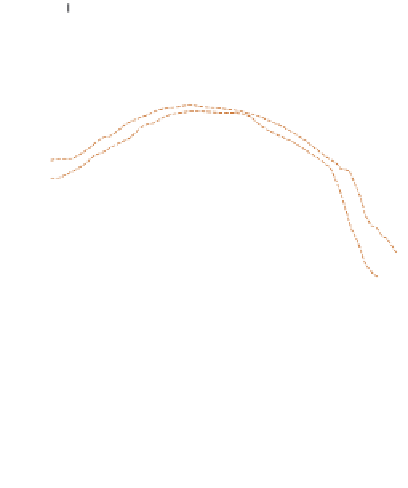
Figure 8.3
Comparison of zonally averaged
surface temperatures for December to February
and June to August as simulated by the AMIP
models compared with observations (bold line).
Source:AMIP website.
1
Forcing times
. The characteristic timespans
over which natural and anthropogenic changes
of input occur. In the case of the former, these
can be periods of solar radiation cycles or the
effect of volcanism and in the case of the latter
the average time interval over which significant
changes of such anthropogenic effects as
increased atmospheric CO
2
occur.
2
Storage times
. For each compartment of the
atmosphere and ocean subsystems these
are the average times taken for an input of
thermal energy to diffuse and mix within the
compartment. For the earth subsystem, the
average times are those required for inputs of
water to move through each compartment.
although there can be large deviation between
individual models. The evaluation of models
requires analysis of their ability to reproduce
interannual variability and synoptic-scale vari-
ability as well as mean conditions. A comparison
project for AOGCMs similar to AMIP is now
underway called the Coupled Model Inter-
comparison Project (CMIP).
Recent models incorporate improved spatial
resolution and fuller treatment of some previously
neglected physical processes. However, both
changes may create additional problems as a result
of the need to accurately treat complex inter-
actions between the land surface (including soil
moisture and canopy structure.) and the atmos-
pheric boundary layer, or interactions between
clouds, radiative exchanges and precipitation
mechanisms. For example, fine-scale spatial
resolution is necessary in the explicit treatment of
These simulations can be performed in several
different ways. A common procedure is to analyze
the model's sensitivity to a specified change in
a single variable. This may involve changes
in external forcing (increased/decreased solar
radiation, atmospheric CO
2
concentrations, or a