Geoscience Reference
In-Depth Information
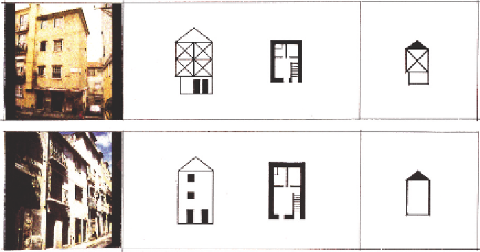
(a)
(b)
Fig. 13
Constructive typologies used before the earthquake: a) house of narrow front with an
external wall forming a “bump”; b) house of narrow front with a roof of “four attics”
Figure 13 shows two examples of the typologies of the houses above described,
presenting photos, elevations of the buildings and schematic cross-sections (Santos
et al.
1993).
4.2 Quantification of Damage
Great uncertainties still do exist on the performance of building structures and mon-
uments, extremely devastated by the earthquake, as well as on the number of victims
caused by the earthquake throughout Portugal.
In relation to monuments it was possible to identify 419 in the area of the present
City of Lisbon, classifying them according to the classes referred in Section 4.1. The
damage inflicted by the earthquake was differentiated into 5 levels, from no damage
to total collapse. Figure 14 shows the geographical distribution of those monuments
in the central area of Lisbon, and Fig. 15 the damage statistics.
From Fig. 15 one can see that structures of larger dimensions suffered larger
damages than small structures. This behaviour can be explained by the proximity of
the frequencies of the incoming waves with the frequencies of the structures which
cause a resonance phenomenon. As larger structures exhibit lower natural frequen-
cies, the above referred behaviour supports the idea that the incoming seismic waves
were with energy predominantly in the longer periods originated by sources away
from Lisbon.
New studies are being made compiling all the available information on the type
geometry and dimensions of the monuments, damage level sustained, and the type
of soil profile underneath. The use of GIS technology is being applied to more easily
establish correlations with the different parameters intervening. In this study we try
to separate damage caused by the shaking from damage due to fire or even due to
Search WWH ::

Custom Search