Geoscience Reference
In-Depth Information
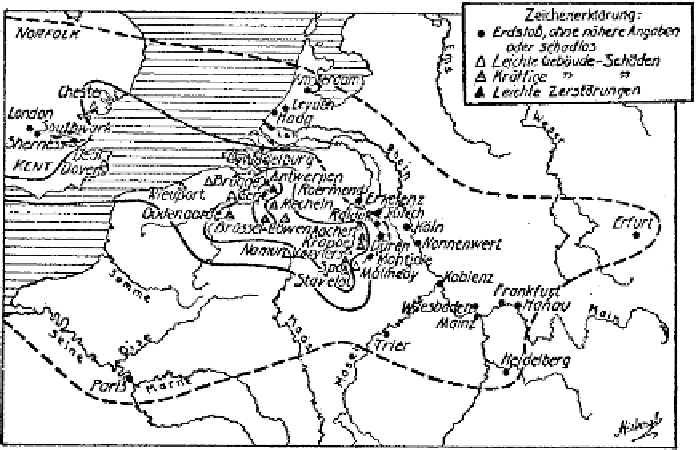
Fig. 3
Macroseismic map of the 18 September 1692 by Sieberg (1940)
unnoted documents, Vogt assumes that the epicentral area is not in the province of
Brabant, but is located in a triangle Liege - Verviers - Aachen (Fig. 2). Vogt re-
marks the importance of the damage in castles, churches and houses in the Verviers
area, where he suggests intensities VII-VIII or VIII in the M.S.K. scale. He also
provides new elements for estimating the other local intensities and determining the
boundaries of the perceptibility area.
As far as the effects of the shock in England are concerned, new original data
were supplied from English records and newspapers by Morse (1983) and also by
Melville and Ambraseys (1983).
The catalogue of Van Gils and Leydecker (1991) does not at all take the Vogt's
new research into account and still locates the epicentre of the 1692 earthquake at
the coordinates of the town of Tienen.
At the same time, a new catalogue of the earthquakes in Belgium and neighbour-
ing areas was elaborated in the Royal Observatory of Belgium, and the study of
Alexandre and Kupper (1997) presents a critical account of all the known records
concerning the earthquake of September 1692 and the ensuing pilgrimage to Our
Lady of the Recollets in Verviers.
Since then some new material about this event was provided in different papers
by Camelbeeck et al. (1999, 2000), and Alexandre et al. (2005). The last paper
discusses the damage to the architectural heritage.
The purpose of the present paper is to describe on (1) the results of new investiga-
tions in old written evidence - for instance in a very useful source, the “
Unglucks-
Chronica
”, a topic already published at the end of the year 1692, which contains
contemporaneous reports from local newspapers -, (2) to discuss the problems of
Search WWH ::

Custom Search