Geoscience Reference
In-Depth Information
Macroseismic intensities come from the original, quoted studies and are given
in the Mercalli-Cancani-Sieberg scale (MCS). Magnitudes come from current para-
metric catalogues: Postpischl (1985a), uses Mm; CPTI04 uses Mw.
2 Historical Investigation up to 1995
2.1 Background
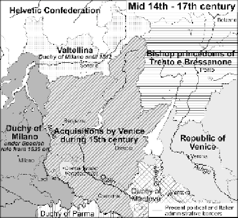
As most of Northern Italy, from the 11th to the 13th century the area was fragmented
into a number of small lordships and counties under either imperial or ecclesiastic rule,
some of them evolving in independent Communes. The governmental institutions and
their territorial extensions underwent many changes along the two centuries from mid
13th to mid 15th century, and as a consequence of these contrasts and disputes, two
main regional states affirmed their respective area of influence: with the Adda and
Oglio Rivers as a border (Fig. 2), they were (i) the Republic of Venice to the east,
(ii) and to the west the Duchy of Milano, or the possession of the powerful families
of Visconti and then Sforza (14th-mid 16th century), under Spanish rule from 1535
on. The area of Valtellina, northern Lombardy, belonged to the Duchy of Milano for
about two centuries; in 1512 it passed under the rule of the Helvetic Confederation.
The valleys around Trento and Bolzano, an area known also as the historical Tyrol,
were quite uninterruptedly ruled by the Bishop Princes of German origin.
As a consequence of these geopolitical and linguistic differences, the main authors
of Italian earthquake compilations, such as Mercalli (1883), Baratta (1901), etc. made
use of primary information which incorporated just a few sources from Valtellina and
the areas of Trento and Bolzano (the last ones were annexed to Italy in 1918).
Fig. 2
Political frontiers and
modifications between mid
14th and 17th century
Search WWH ::

Custom Search