Geoscience Reference
In-Depth Information
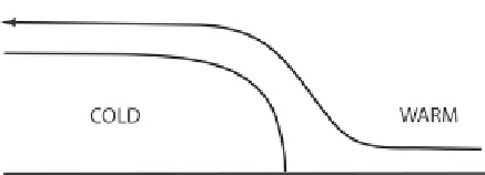
Figure 5.6. Illustration of how a low-level jet (LLJ) oriented normal to a surface boundary
such as an outflow boundary or front can lead to locally enhanced lift for triggering convection.
(Top) Horizontal view of the LLJ (vector) advecting warm, moist air across a surface boundary
towards the cold side. A narrow zone of warm advection results in quasi-geostrophic lift that is
concentrated along a portion of the boundary. (Bottom) Vertical cross section showing how the
LLJ enhances lift over the cold pool/cold side of the front locally, in addition to the outflow
boundary normal flow that is created by its motion from the cold side towards the warm side.
a gust front, above which there is a shelf cloud (
Figure 5.9
), which is formed as
environmental air ahead of the MCS is lifted over the cold pool behind the gust
front.
When the leading convective line is followed by a stratiform precipitation
region that is centered approximately to the rear (with respect to MCS motion) of
the MCS, the MCS is said to be ''symmetric'' (
Figure 5.11a
). When the leading
convective line, however, is centered or is more intense off to the southern, south-
western, or western side (in the Great Plains of the U. S.), the MCS is said to be
''asymmetric'' (
Figure 5.11b
).
Symmetric MCSs often evolve into asymmetric MCSs, since with time the
Coriolis force becomes significant and convergence at mid-levels above the
sinking, evaporatively cooled air and below mesoscale ascending air above in
the stratiform precipitation region, acts on Earth's vorticity to produce cyclonic
2
There is not always a distinct difference between the leading convective line and the stratiform
precipitation region. In general, however, the number of convective towers decreases with
increasing distance behind the leading convective line.

Search WWH ::

Custom Search