Geoscience Reference
In-Depth Information
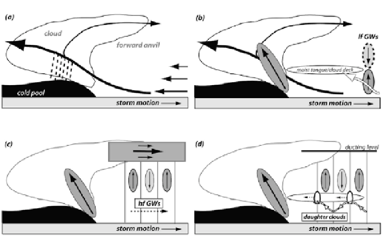
Figure 5.5. Conceptual model of sequence of events that occur when a nocturnal squall line
propagates ahead of itself discretely as convection is initiated ahead of the leading convective
line, as high-frequency gravity waves (hf GWs) are triggered by the squall line's periodic
formation of convective cells (multicellularity) and ducted in the forward anvil, where the
Scorer parameter decreases rapidly with height. A moist tongue/cloud deck forms as a result of
low-frequency gravity waves (lf GWs) forced by heating and cooling in the squall
line's
convective region (from Fovell et al., 2006).
convective systems, from an isolated cell to an MCS, without the need for any
initial forcing along a line. The leading edge of an approaching MCS cold pool is
seen in
Figure 5.9.
5.2 MORPHOLOGY
While many MCSs begin as narrow squall lines, they eventually broaden with
time. A narrow, leading convective line eventually may develop a trailing region
of stratiform precipitation that is much broader than the narrow width of the
leading convective line (
Figure 5.2
). While the rainfall rate in the stratiform pre-
cipitation region is less than that in the more intense leading convective line, an
observer in the former would experience precipitation for a much longer period of
time than an observer in the latter, and so the total (integrated with respect to
time) rainfall experienced may be largely due to that from the stratiform region.
In between the intense leading convective line and the stratiform precipitation
region there is a region of weaker precipitation rate (a narrow zone of weaker
radar reflectivity at low levels) that Brad Smull and Bob Houze named the
Search WWH ::

Custom Search