Geoscience Reference
In-Depth Information
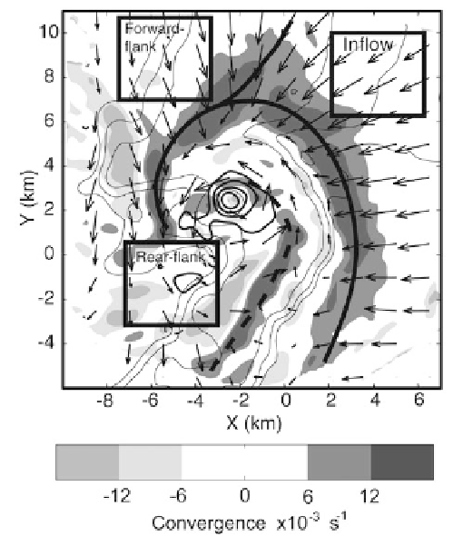
Figure 4.18. Multiple RFD surges in a tornadic supercell, as documented by two DOWmobile
Doppler radars in northwest Texas on April 30, 2000. Storm-relative wind field depicted by
vectors. Convergence is coded by gray shading. Solid lines represent primary forward-flank and
rear-flank gust fronts, though only a gradual wind shift is evident in the forward flank. The
secondary rear-flank gust front is represented by a dashed line. Equivalent radar reflectivity
factor is contoured every 5 dBZ
e
, beginning at 20 dBZ
e
(from Marquis et al., 2008).
cussed later, the width and magnitude of the surface temperature gradient at the
right edge of the FFD and the associated wind field may play a role in low-level
mesocyclogenesis and in tornadogenesis. Much of the FFD originates as precipita-
tion falls from the downshear anvil region. The origin of the FFD is therefore a
natural consequence of any convective storm in the presence of vertical shear.
However, the RFD's appearance on the upshear side of the storm is suggestive of
the importance of storm rotation, because air must be driven backwards against
the environmental flow, and the importance of vertical shear, which promotes
storm rotation and can be responsible for evaporation as dry environmental air
catches up with a more slowly moving storm and is entrained into a region of
precipitation on the rear side of the storm (
Figure 4.19
).
The differential reflectivity Z
DR
is often high near the edge of the forward-
Matt Kumjian at OU has shown that this feature may be created when the
Search WWH ::

Custom Search